Location
Latitude: |
39-20-41.8630N (39.344962) |
Longitude: |
081-26-21.4550W (-81.439293) |
Elevation: |
858.5 feet MSL (262 m MSL) |
Magnetic Variation: |
8.2 W (as of April 2024 from WMM2020 model) |
Time Zone: |
UTC -5.0 (Standard Time) UTC -4.0 (Daylight Savings Time) |
From City: |
06 N.M. NE of Parkersburg, West Virginia |
Found On: |
Cincinnati Chart |
FAA Region: |
AEA |
Contacts
Manager: |
Publicly owned: |
| BENJAMIN AUVILLE ROUTE 31 & AIRPORT ROAD, BOX 4089 WILLIAMSTOWN, WV 26187 304-464-5113 |
WOOD CO. ARPT AUTH P.O. BOX 4089 PARKERSBURG, WV 26104-4089 304-464-5113 |
Operations
Airport Status: |
Operational |
Facility Use: |
Public |
Type: |
Airport |
Activation Date: |
10/1938 |
Control tower: |
Yes |
Attendance (Months/Days/Hours): |
Months/Days/Hours ALL/ALL/0430-2130 |
Boundary ARTCC: |
ZID (Indianapolis) |
Responsible ARTCC: |
ZID (Indianapolis) |
Lighting Schedule: |
SEE RMK |
Segmented Circle Indicator: |
No |
Traffic Pattern Altitude (MSL): |
1858 feet (566 m) |
NOTAMs Facility: |
PKB |
NOTAM-D Service: |
Yes |
International Airport of Entry: |
No |
Customs Landing Rights: |
No |
Military Landing Rights: |
Yes |
Civil/Military Joint Use: |
No |
Aircraft Rescue and Firefighting: |
Class I ARFF Index: A Air Carrier Service: Scheduled Certification Date: 11/1980 |
Based Aircraft
| Single Engine: | 38 |
| Multi Engine: | 6 |
| Jet Engine: | 7 |
| Military Aircraft: | 11 |
Annual Operations (as of 12/31/2022)
| Total Operations: | 31005 | |
| Air Taxi: | 2369 | 7.6% |
| GA Local: | 9808 | 31.6% |
| GA Itinerant: | 8085 | 26.1% |
| Military Aircraft: | 10743 | 34.6% |
Communications
| CTAF: | 123.700 |
| Unicom: | 122.950 |
| Tower: | PARKERSBURG 123.7 257.8 Hrs: 0700-2300 |
| Ground: | 126.45 |
| Approach: | INDIANAPOLIS ARTCC |
| Departure: | INDIANAPOLIS ARTCC |
| ATIS: | 124.35 Hrs: 24 |
| ASOS: | (304-464-1001) |
| EMERG: | 121.5 |
| EMERG: | 243.0 |
| ARNG OPS: | 248.3 |
- APCH/DEP SVC PRVDD BY INDIANAPOLIS ARTCC ON FREQS 125.55/317.475 (PARKERSBURG RCAG).
Fixed Based Operators (FBOs) & Fuel
(Click on a business for detail)
Please help us keep this information up to date. This is a FREE SERVICE just like everything else on Airport Guide! If you see that a business needs to be added, modified, or deleted please fill out our Update Form.
To add, modify, or delete a business click here.
Please help us keep this information up to date. This is a FREE SERVICE just like everything else on Airport Guide! If you see that a business needs to be added, modified, or deleted please fill out our Update Form.
Area Code: 304 |
| Business Name | Frequency | Phone | Fuel Grade |
|---|---|---|---|
| Rambar Aviation
Update FBO info |
464-4450 | ||
| Wood County Airport Authority
Update FBO info |
Unicom 122.95 | 464-5115 | Air BP - 80, Exxon - 100LL, Jet A |
Flight Service Stations
| Primary | Alternate | |
| FSS on Field: | N | |
| FSS Name (ID): | Elkins(EKN) | |
| Frequency: | ||
| Toll Free Phone: | 1-800-WX-BRIEF |
Instrument Procedures / Charts
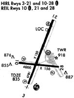
FAA Terminal Procedures valid from 0901Z 03/21/24 to 0901Z 04/18/24.
There are various types of charts available for an airport. They are listed in the Page Type column. Here is a legend for those types:
APD - Airport Diagram
DP - Departure Procedure Charts
HOT - Hot Spots
IAP - Instrument Approach Procedure Charts
MIN - Minimums
STAR - Standard Terminal Arrival Charts
| Page Type | Page Name | Volume | Action Since Last Cycle |
|---|---|---|---|
| APD | AIRPORT DIAGRAM | NE-4 | |
| IAP | ILS OR LOC RWY 03 | NE-4 | |
| IAP | RNAV (GPS) RWY 03 | NE-4 | |
| IAP | RNAV (GPS) RWY 10 | NE-4 | |
| IAP | RNAV (GPS) RWY 21 | NE-4 | Changed |
| IAP | RNAV (GPS) RWY 28 | NE-4 | |
| IAP | VOR RWY 21 | NE-4 | |
| MIN | ALTERNATE MINIMUMS | NE-4 | |
| MIN | TAKEOFF MINIMUMS | NE-4 |
Terminal Procedures are only available for airports in several countries with more being added all the time. If you are looking for a specific country's charts, please send an email to support(at)airportguide.com stating the country name. This will be used to prioritize the implementation.
Navigation Aids (Navaids) near PKB
| Dist (NM) | ID | Morse Code | Name | Type | Freq | True Hdg | Mag Hdg |
|---|---|---|---|---|---|---|---|
| 2.7 | PKB | . _ _ . _ . _ _ . . . | Marietta Ohio | FAN MARKER | 25 | 33 | |
| 5.9 | PK | . _ _ . _ . _ | Versi | NDB | 388 | 201 | 209 |
| 6.5 | JPU | . _ _ _ . _ _ . . . _ | Parkersburg | VOR-DME | 114.45 | 27 | 35 |
| 32.3 | UGS | . . _ _ _ . . . . | University | NDB | 250 | 260 | 268 |
| 35.9 | UNI | . . _ _ . . . | Athens | FAN MARKER | 258 | 266 | |
| 40.3 | HRA | . . . . . _ . . _ | Zanesville | NDB | 204 | 326 | 334 |
| 41.4 | ZZV | _ _ . . _ _ . . . . . _ | Zanesville | VOR-DME | 114.95 | 329 | 337 |
| 44.8 | HNN | . . . . _ . _ . | Henderson | DME | 115.9 | 217 | 225 |
| 49.5 | AIR | . _ . . . _ . | Bellaire | VOR-DME | 117.10 | 35 | 43 |
| 53.1 | CTW | _ . _ . _ . _ _ | Newcomerstown | DME | 111.8 | 358 | 366 |
| 54.7 | CKB | _ . _ . _ . _ _ . . . | Clarksburg | VOR-DME | 112.60 | 95 | 104 |
| 57.0 | CFX | _ . _ . . . _ . _ . . _ | Cadiz | NDB | 239 | 20 | 28 |
| 58.8 | CRW | _ . _ . . _ . . _ _ | Charleston | VOT | 108.80 | 187 | 195 |
| 61.7 | HVQ | . . . . . . . _ _ _ . _ | Charleston | VOR-DME | 117.40 | 194 | 202 |
| 62.5 | HEH | . . . . . . . . . | Newark | NDB | 524 | 311 | 319 |
| 67.5 | EKN | . _ . _ _ . | Elkins | VORTAC | 114.20 | 112 | 121 |
| 68.0 | HLG | . . . . . _ . . _ _ . | Wheeling | VOR-DME | 114.25 | 35 | 44 |
| 70.1 | EOP | . _ _ _ . _ _ . | Waverly | NDB | 385 | 261 | 269 |
| 71.8 | APE | . _ . _ _ . . | Appleton | VORTAC | 116.70 | 312 | 320 |
| 71.9 | CM | _ . _ . _ _ | Sumie | NDB | 391 | 302 | 310 |
Nearby Airports with Fuel
Notices to Airmen (NOTAMS)
Remarks
| A110-1 | BIRDS & DEER ON & INVOF ARPT. |
| A110-3 | NO LANDING FEE FOR ACFT LESS THAN 6500 LBS; FOR ACFT GREATER THAN 6500, LNDG FEE WAIVED WITH FUEL PURCHASES. |
| A110-4 | ARNG OPS DSN 661-3400 C304-464-4530. |
| A110-5 | WHEN ATCT CLSD, FOR CD CTC INDIANAPOLIS ARTCC AT 317-247-2411. |
| A12 | FEDEX DELIVERY: 543 AIRPORT RD, WILLIAMSTOWN, WV 26187 |
| A26 | PPR 30 MIN FOR UNSCHEDULED ACR OPNS WITH MORE THAN 30 PSGR SEATS; CALL AMGR (304) 464-5115. |
| A43-21 | UNUSBL BYD 5 DEGS LEFT AND 9 DEGS RIGHT OF CNTRLN. |
| A43-28 | UNUSBL BYD 8 DEGS LEFT AND 8 DEGS RIGHT OF CNTRLN. |
| A81-APT | WHEN ATCT CLSD ACTVT MALSR RWY 03; REIL RWY 10 & 21; HIRL RWY 03/21 & 10/28 - CTAF. PAPI RWY 03 & 21 OPR CONSLY. REIL RWY 28 UNAVBL WHEN ATCT CLSD. |
Runways
Runway Summary
| Runways: | 03/21 10/28 |
| Longest Runway: | 03/21 is 7240 ft (2207 m) long |
| Runways with an Instrument Approach: | 03 |
PKB Airport Runway Details
| Runway 03/21 | 7240 ft x 150 ft (2207 m x 46 m) | |
| Runway Length Source: | 3RD PARTY SURVEY as of 08/05/2020 | |
| Surface: | Asphalt - Good condition - Saw-cut or plastic grooved | |
| Runway Pavement Class: | 31 /R/C/X/T | |
| Runway Edge Lights: | High Intensity | |
Runway Weight Bearing Capacity (in thousands of pounds) |
||
| Single Wheel Landing Gear: | 85.0 | |
| Dual Wheel Landing Gear: | 100.0 | |
| Dual Tandem Wheel Landing Gear: | 175.0 | |
Runway 03 |
Runway 21 |
|
Elevation: |
803.0 | 858.5 |
Latitude: |
39-20-13.0131N | 39-21-19.3564N |
Longitude: |
081-26-37.9523W | 081-26-03.4257W |
|
Runway True Alignment: |
022 | 202 |
ILS Type: |
ILS | |
Glide Path Angle: |
3.0 degrees | 3.0 degrees |
Traffic Pattern: |
Left | Left |
Runway Markings Type: |
Precision Instrument | Precision Instrument |
Runway Markings Condition: |
Good | Good |
Visual Glide Slope Indicators: |
4-Light PAPI On Left Side Of Runway | 4-Light PAPI On Right Side Of Runway |
Runway Visual Range (RVR): |
Touchdown, Rollout | Touchdown, Rollout |
Approach Light System: |
1,400 Foot Medium Intensity Approach Lighting System With Runway Alignment Indicator Lights | |
REIL: |
Yes | |
Threshold Crossing Height: |
49 | 56 |
Threshold Elevation: |
856.9 | |
Displaced Threshold: |
460 | |
Threshold Latitude: |
39-21-15.1434N | |
Threshold Longitude: |
081-26-05.6188W | |
Declared Distances |
||
Take Off Run Avbl. (TORA): |
7240 | 7240 |
Take Off Distance Avbl. (TODA): |
7240 | 7240 |
Actual Stop Dist. Avbl. (ASDA): |
6780 | 7240 |
Landing Dist. Avbl. (LDA): |
6780 | 6780 |
| Runway 10/28 | 4002 ft x 150 ft (1220 m x 46 m) | |
| Runway Length Source: | 3RD PARTY SURVEY as of 01/12/2017 | |
| Surface: | Asphalt - Good condition - Saw-cut or plastic grooved | |
| Runway Pavement Class: | 30 /R/C/X/T | |
| Runway Edge Lights: | High Intensity | |
Runway Weight Bearing Capacity (in thousands of pounds) |
||
| Single Wheel Landing Gear: | 50.0 | |
| Dual Wheel Landing Gear: | 75.0 | |
| Dual Tandem Wheel Landing Gear: | 135.0 | |
Runway 10 |
Runway 28 |
|
Elevation: |
830.7 | 838.3 |
Latitude: |
39-20-35.7671N | 39-20-32.3200N |
Longitude: |
081-26-48.2086W | 081-25-57.4676W |
|
Runway True Alignment: |
095 | 275 |
Glide Path Angle: |
3.0 degrees | 3.0 degrees |
Traffic Pattern: |
Left | Left |
Runway Markings Type: |
Nonprecision Instrument | Nonprecision Instrument |
Runway Markings Condition: |
Fair | Fair |
Visual Glide Slope Indicators: |
2-Light PAPI On Left Side Of Runway | 2-Light PAPI On Left Side Of Runway |
REIL: |
Yes | Yes |
Threshold Crossing Height: |
46 | 43 |
Declared Distances |
||
Take Off Run Avbl. (TORA): |
4002 | 4002 |
Take Off Distance Avbl. (TODA): |
4002 | 4002 |
Actual Stop Dist. Avbl. (ASDA): |
4002 | 4002 |
Landing Dist. Avbl. (LDA): |
4002 | 4002 |
Services
Airframe Repair: |
Minor |
Powerplant Repair: |
Minor |
Bottled Oxygen: |
None |
Bulk Oxygen: |
None |
Fuel Available: |
100LL, Jet A, Jet A+ |
Landing Fees: |
No |
Parking: |
Hangars and tiedowns available |
Maps & Diagrams
PKB Sectional
Flight Planning
at skyvector.com
at skyvector.com