Location
Latitude: |
57-53-05.7300N (57.884925) |
Longitude: |
152-50-51.2600W (-152.847572) |
Elevation: |
42.0 feet MSL (13 m MSL) |
Magnetic Variation: |
13.5 E (as of April 2024 from WMM2020 model) |
Time Zone: |
UTC -9.0 (Standard Time) UTC -8.0 (Daylight Savings Time) |
From City: |
02 N.M. NNE of Port Lions, Alaska |
Found On: |
Kodiak Chart |
FAA Region: |
AAL |
Contacts
Manager: |
Publicly owned: |
| PHIL SMITH 1500 ANTON LARSON RD KODIAK, AK 99615 (907) 487-4952 |
ALASKA DOT&PF SOUTHCOAST REGION PO BOX 112506 JUNEAU, AK 99811-2506 (907) 487-4952 |
Operations
Airport Status: |
Operational |
Facility Use: |
Public |
Type: |
Airport |
Control tower: |
No |
Attendance (Months/Days/Hours): |
Months/Days/Hours Unattended |
Boundary ARTCC: |
ZAN (Anchorage) |
Responsible ARTCC: |
ZAN (Anchorage) |
Lighting Schedule: |
SEE RMK |
Segmented Circle Indicator: |
No |
Traffic Pattern Altitude (MSL): |
1042 feet (318 m) |
NOTAMs Facility: |
ENA |
NOTAM-D Service: |
Yes |
International Airport of Entry: |
No |
Customs Landing Rights: |
No |
Military Landing Rights: |
Yes |
Civil/Military Joint Use: |
No |
Based Aircraft
Annual Operations (as of 12/31/2021)
| Total Operations: | 5300 | |
| Air Taxi: | 4800 | 90.6% |
| GA Itinerant: | 500 | 9.4% |
Communications
| CTAF: | 122.800 |
| Unicom: | 122.800 |
Fixed Based Operators (FBOs) & Fuel
(Click on a business for detail)
Please help us keep this information up to date. This is a FREE SERVICE just like everything else on Airport Guide! If you see that a business needs to be added, modified, or deleted please fill out our Update Form.
To add, modify, or delete a business click here.
Please help us keep this information up to date. This is a FREE SERVICE just like everything else on Airport Guide! If you see that a business needs to be added, modified, or deleted please fill out our Update Form.
Area Code: 487 |
| Business Name | Frequency | Phone | Fuel Grade |
|---|
Flight Service Stations
| Primary | Alternate | |
| FSS on Field: | N | |
| FSS Name (ID): | Kenai(ENA) | |
| Frequency: | ||
| Toll Free Phone: | 1-866-864-1737 |
Instrument Procedures / Charts
Terminal Procedures are only available for airports in several countries with more being added all the time. If you are looking for a specific country's charts, please send an email to support(at)airportguide.com stating the country name. This will be used to prioritize the implementation.
Navigation Aids (Navaids) near ORI
Nearby Airports with Fuel
| Dist (NM) | Name (Airport IDs) | True Hdg | Mag Hdg | Fuel Grade |
|---|---|---|---|---|
| 15.6 | Kodiak /Lilly Lake/ Seaplane Base (9Z3) |
108 | 94 | 100LL |
Notices to Airmen (NOTAMS)
Remarks
| A110-1 | BE ALERT: SUBJ TO DOWNDRAFTS DURING NE WINDS. |
| A110-2 | RY CONDITION NOT MONITORED; RECOMMEND VISUAL INSPECTION PRIOR TO USING. |
| A110-3 | VEHICLES CROSS RY NEAR THLD 06 & USE SAFETY AREAS AS ROADWAYS. |
| A110-4 | WX CAMERA AVBL ON INTERNET AT HTTPS://WEATHERCAMS.FAA.GOV |
| A42-07 | BOTH THLDS MARKED WITH REFLECTIVE CONES & LIGHTS, BUT OVERGROWN WITH GRASSES AND ALDERS. |
| A52-07 | OTHER OBSTRUCTIONS INCLUDE TREES ON HILL APPROXIMATELY 200 FT ABOVE THLD 956 FT FM RY END. |
| A81-APT | ACTVT MIRL RY 06/24 - CTAF. |
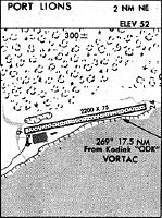
Runways
Runway Summary
| Runways: | 07/25 |
| Longest Runway: | 07/25 is 2200 ft (671 m) long |
| Runways with an Instrument Approach: |
ORI Seaplane Base Runway Details
| Runway 07/25 | 2200 ft x 75 ft (671 m x 23 m) | |
| Runway Length Source: | STATE as of 01/14/2014 | |
| Surface: | Gravel - Good condition - No special surface treatment | |
| Runway Edge Lights: | Medium Intensity | |
Runway 07 |
Runway 25 |
|
Elevation: |
42.0 | 42.0 |
Latitude: |
57-53-03.6700N | 57-53-07.7900N |
Longitude: |
152-51-11.2500W | 152-50-31.2700W |
|
Runway True Alignment: |
079 | 259 |
Glide Path Angle: |
0.0 degrees | 0.0 degrees |
Traffic Pattern: |
Right | Left |
Object at End: |
TREE | BRUSH |
Object Height: |
28 | 12 |
Distance from End: |
21 | 0 |
Object Centerline Offset: |
96 ft. left of centerline | 87 ft. left of centerline |
Services
Airframe Repair: |
None |
Powerplant Repair: |
None |
Bottled Oxygen: |
None |
Bulk Oxygen: |
None |
Fuel Available: |
100LL |
Landing Fees: |
No |
Maps & Diagrams
ORI Sectional
Flight Planning
at skyvector.com
at skyvector.com