Location
Latitude: |
30-12-18.1000N (30.205028) |
Longitude: |
091-59-15.9000W (-91.98775) |
Elevation: |
41.7 feet MSL (13 m MSL) |
Magnetic Variation: |
0.2 W (as of April 2024 from WMM2020 model) |
Time Zone: |
UTC -6.0 (Standard Time) UTC -5.0 (Daylight Savings Time) |
From City: |
02 N.M. SE of Lafayette, Louisiana |
Found On: |
Houston Chart |
FAA Region: |
ASW |
Contacts
Manager: |
Publicly owned: |
| STEVEN L. PICOU, EXECUTIVE DIRECTOR 200 TERMINAL DRIVE, SUITE 200 LAFAYETTE, LA 70508-2124 337-703-4800 |
CITY PARISH OF LAFAYETTE 200 TERMINAL DRIVE, SUITE 200 LAFAYETTE, LA 70508 337-703-4800 |
Operations
Airport Status: |
Operational |
Facility Use: |
Public |
Type: |
Airport |
Activation Date: |
04/1940 |
Control tower: |
Yes |
Attendance (Months/Days/Hours): |
Months/Days/Hours ALL/ALL/ALL |
Boundary ARTCC: |
ZHU (Houston) |
Responsible ARTCC: |
ZHU (Houston) |
Lighting Schedule: |
SEE RMK |
Segmented Circle Indicator: |
Yes |
Traffic Pattern Altitude (MSL): |
1042 feet (318 m) |
NOTAMs Facility: |
LFT |
NOTAM-D Service: |
Yes |
International Airport of Entry: |
No |
Customs Landing Rights: |
Yes |
Military Landing Rights: |
Yes |
Civil/Military Joint Use: |
No |
Aircraft Rescue and Firefighting: |
Class I ARFF Index: B Air Carrier Service: Scheduled Certification Date: 05/1973 |
Based Aircraft
| Single Engine: | 66 |
| Multi Engine: | 14 |
| Jet Engine: | 31 |
| GA Helicopters: | 5 |
Annual Operations (as of 12/31/2023)
| Total Operations: | 42850 | |
| Commercial: | 7247 | 16.9% |
| Air Taxi: | 9283 | 21.7% |
| GA Local: | 7017 | 16.4% |
| GA Itinerant: | 18604 | 43.4% |
| Military Aircraft: | 699 | 1.6% |
Communications
| CTAF: | 118.500 |
| Unicom: | 122.950 |
| Tower: | LAFAYETTE 118.5 257.8 Hrs: 0530-2230 |
| Clearance Del.: | 125.55 |
| Ground: | 121.8 |
| Approach: | LAFAYETTE 121.1 ;020-210 128.7 ;211-019 268.7 ;211-019 363.0 ;020-210 Hrs: 0530-2230 HOUSTON ARTCC Hrs: 2230-0530 |
| Departure: | LAFAYETTE 121.1 ;020-210 128.7 ;211-019 268.7 ;211-019 363.0 ;020-210 Hrs: 0530-2230 HOUSTON ARTCC Hrs: 2230-0530 |
| ATIS: | 134.05 Hrs: 24 |
| ASOS: | 134.05 ((337)262-2757) |
| EMERG: | 243.0 |
| CLASS C: | 121.1 ;020-210 |
| EMERG: | 121.5 |
| CLASS C: | 268.7 ;211-019 |
| CLASS C: | 363.0 ;020-210 |
| CLASS C: | 128.7 ;211-019 |
- APCH/DEP SVC PRVDD BY HOUSTON ARTCC (ZHU) ON FREQS 126.35/338.25 (LAFAYETTE RCAG) WHEN LAFAYETTE APCH CTL (LFT) CLSD.
Fixed Based Operators (FBOs) & Fuel
(Click on a business for detail)
Please help us keep this information up to date. This is a FREE SERVICE just like everything else on Airport Guide! If you see that a business needs to be added, modified, or deleted please fill out our Update Form.
To add, modify, or delete a business click here.
Please help us keep this information up to date. This is a FREE SERVICE just like everything else on Airport Guide! If you see that a business needs to be added, modified, or deleted please fill out our Update Form.
Area Code: 337 |
| Business Name | Frequency | Phone | Fuel Grade |
|---|---|---|---|
| Dallas Airmotive
Website Update FBO info |
233-6386 | ||
| Lafayette Aero, Inc.
Update FBO info |
Unicom 122.95 | 234-3100, 324-3115, 233-4129 | 100LL, Jet A |
| Paul Fournet Air Service, Inc.
Update FBO info |
Unicom 122.95, Arinc 128.85 | 237-0520 | 100LL, Jet A |
| Signature Flight Support
Update FBO info |
Arinc: 122.95 | +1 337 234 3100 |
Flight Service Stations
| Primary | Alternate | |
| FSS on Field: | N | |
| FSS Name (ID): | De Ridder(DRI) | |
| Frequency: | ||
| Toll Free Phone: | 1-800-WX-BRIEF |
Instrument Procedures / Charts
FAA Terminal Procedures valid from 0901Z 03/21/24 to 0901Z 04/18/24.
There are various types of charts available for an airport. They are listed in the Page Type column. Here is a legend for those types:
APD - Airport Diagram
DP - Departure Procedure Charts
HOT - Hot Spots
IAP - Instrument Approach Procedure Charts
MIN - Minimums
STAR - Standard Terminal Arrival Charts
| Page Type | Page Name | Volume | Action Since Last Cycle |
|---|---|---|---|
| APD | AIRPORT DIAGRAM | SC-4 | |
| HOT | HOT SPOT | SC-4 | |
| IAP | ILS OR LOC RWY 04R | SC-4 | |
| IAP | ILS OR LOC RWY 22L | SC-4 | |
| IAP | RNAV (GPS) RWY 04R | SC-4 | |
| IAP | RNAV (GPS) RWY 22L | SC-4 | |
| IAP | RNAV (GPS) RWY 29 | SC-4 | |
| IAP | VOR/DME RWY 11 | SC-4 | |
| MIN | ALTERNATE MINIMUMS | SC-4 | |
| MIN | TAKEOFF MINIMUMS | SC-4 |
Terminal Procedures are only available for airports in several countries with more being added all the time. If you are looking for a specific country's charts, please send an email to support(at)airportguide.com stating the country name. This will be used to prioritize the implementation.
Navigation Aids (Navaids) near LFT
| Dist (NM) | ID | Morse Code | Name | Type | Freq | True Hdg | Mag Hdg |
|---|---|---|---|---|---|---|---|
| 0.7 | LFT | . _ . . . . _ . _ | Lafayette | VORTAC | 109.80 | 200 | 200 |
| 6.5 | LF | . _ . . . . _ . | Laffs | NDB | 375 | 39 | 39 |
| 11.1 | BNZ | _ . . . _ . _ _ . . | Abbeville | NDB | 230 | 219 | 219 |
| 16.3 | AR | . _ . _ . | Acadi | NDB | 269 | 156 | 156 |
| 27.6 | OPL | _ _ _ . _ _ . . _ . . | St Landry | NDB | 335 | 348 | 348 |
| 32.0 | ECY | . _ . _ . _ . _ _ | Duralde | NDB | 263 | 311 | 311 |
| 36.4 | FWX | . . _ . . _ _ _ . . _ | New Roads | NDB | 356 | 44 | 44 |
| 38.2 | LLA | . _ . . . _ . . . _ | White Lake | VOR-DME | 114.95 | 211 | 211 |
| 39.7 | LSU | . _ . . . . . . . _ | Fighting Tiger | VORTAC | 116.50 | 64 | 64 |
| 41.6 | BWK | _ . . . . _ _ _ . _ | Bunkie | NDB | 397 | 342 | 342 |
| 44.7 | LRR | . _ . . . _ . . _ . | Oakdale | NDB | 379 | 305 | 305 |
| 44.8 | PTN | . _ _ . _ _ . | Patterson | NDB | 245 | 130 | 130 |
| 46.1 | BT | _ . . . _ | Rundi | NDB | 284 | 60 | 60 |
| 53.6 | MKV | _ _ _ . _ . . . _ | Marksville | NDB | 347 | 355 | 355 |
| 58.1 | LCH | . _ . . _ . _ . . . . . | Lake Charles | VORTAC | 113.40 | 266 | 266 |
| 62.9 | CW | _ . _ . . _ _ | Mossy | NDB | 418 | 275 | 275 |
| 68.4 | TBD | _ _ . . . _ . . | Tibby | VOR-DME | 112.00 | 118 | 119 |
| 68.4 | AEX | . _ . _ . . _ | Alexandria | VORTAC | 116.10 | 337 | 337 |
| 72.9 | RQR | . _ . _ _ . _ . _ . | Reserve | VOR-DME | 110.80 | 95 | 96 |
| 74.3 | AUR | . _ . . _ . _ . | Sulphur | NDB | 278 | 270 | 270 |
Nearby Airports with Fuel
Notices to Airmen (NOTAMS)
Remarks
| A110-1 | RWY 11/29; RWY 04L/22R & RWY 04R/22L LGTD DISTANCE REMAINING SIGNS. |
| A110-11 | CTC GND CTL PRIOR TO PUSH BACK FM TERMINAL. |
| A110-13 | USE CTN TWR BLIND SPOTS ON TWY M EAST & WEST OF TWY E. |
| A110-14 | FOR CD IF UNA TO CTC ON FSS FREQ, CTC HOUSTON ARTCC AT 281-230-5622. |
| A110-15 | TAXILANE A AND ALL PRKG RAMPS ARE NON-MOVEMENT AREAS. |
| A110-16 | ATCT HAS LTD VIS OF NORTH PRKG RAMP. |
| A110-4 | 155 FT OIL RIG 1 NM SE OF ARPT. |
| A110-6 | MIGRATORY BIRDS ON & INVOF ARPT. |
| A26 | PPR FOR UNSCHEDULED ACR OPNS WITH MORE THAN 30 PSGR SEATS CALL AMGR 337-703-4800. |
| A30-04L/22R | RWY NOT AVBL FOR ACR OPNS WITH MORE THAN 30 PSGR SEATS. RY CLSD 2230-0530. |
| A30-11/29 | RWY CLSD UFN. |
| A70-FUEL-A+ | CALL 337-234-3100. |
| A81-APT | DUSK-DAWN. WHEN ATCT CLSD ACTVT MALSR RWY 22L - CTAF; MIRL RWY 04L/22R NOT AVBL. |
| E60-04R | ENGINEERED MATERIALS ARRESTING SYSTEM (EMAS) 223 FT IN LENGTH BY 170 FT IN WIDTH LCTD AT THE DER 04R. |
| E60-11 | ENGINEERED MATERIALS ARRESTING SYSTEM (EMAS) 300 FT IN LENGTH BY 170 FT IN WIDTH LCTD AT THE DER 11. |
| E60-22L | ENGINEERED MATERIALS ARRESTING SYSTEM (EMAS) 380.7 FT IN LENGTH BY 170 FT IN WIDTH LCTD AT THE DER 22L. |
| E60-29 | ENGINEERED MATERIALS ARRESTING SYSTEM (EMAS) 448 FT IN LENGTH BY 170 FT IN WIDTH LCTD AT THE DER 29. |
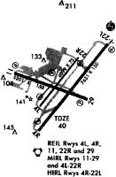
Runways
Runway Summary
| Runways: | 04L/22R 04R/22L 11/29 |
| Longest Runway: | 04R/22L is 8000 ft (2438 m) long |
| Runways with an Instrument Approach: | 04R, 22L |
LFT Airport Runway Details
| Runway 04L/22R | 4099 ft x 75 ft (1249 m x 23 m) | |
| Runway Length Source: | 3RD PARTY SURVEY as of 12/08/2015 | |
| Surface: | Asphalt - Fair condition - No special surface treatment | |
| Runway Pavement Class: | 11 /F/D/X/T | |
| Runway Edge Lights: | Medium Intensity | |
Runway Weight Bearing Capacity (in thousands of pounds) |
||
| Single Wheel Landing Gear: | 25.0 | |
| Dual Wheel Landing Gear: | 32.0 | |
Runway 04L |
Runway 22R |
|
Elevation: |
41.2 | 41.6 |
Latitude: |
30-12-05.8007N | 30-12-37.4292N |
Longitude: |
091-59-33.0761W | 091-59-03.8174W |
|
Runway True Alignment: |
039 | 219 |
Glide Path Angle: |
3.0 degrees | 3.0 degrees |
Traffic Pattern: |
Right | |
Runway Markings Type: |
Nonprecision Instrument | Nonprecision Instrument |
Runway Markings Condition: |
Fair | Fair |
Object at End: |
TREE | TREE |
Object Height: |
27 | 54 |
Distance from End: |
996 | 2364 |
Object Centerline Offset: |
83 ft. left of centerline | 5 ft. right of centerline |
Visual Glide Slope Indicators: |
2-Light PAPI On Left Side Of Runway | 2-Light PAPI On Left Side Of Runway |
REIL: |
Yes | Yes |
Threshold Crossing Height: |
26 | 26 |
Declared Distances |
||
Take Off Run Avbl. (TORA): |
4099 | 4099 |
Take Off Distance Avbl. (TODA): |
4099 | 4099 |
Actual Stop Dist. Avbl. (ASDA): |
4099 | 4099 |
Landing Dist. Avbl. (LDA): |
4099 | 4099 |
| Runway 04R/22L | 8000 ft x 150 ft (2438 m x 46 m) | |
| Runway Length Source: | 3RD PARTY SURVEY as of 12/08/2015 | |
| Surface: | Asphalt - Fair condition - Saw-cut or plastic grooved | |
| Runway Pavement Class: | 67 /F/C/X/T | |
| Runway Edge Lights: | High Intensity | |
Runway Weight Bearing Capacity (in thousands of pounds) |
||
| Single Wheel Landing Gear: | 140.0 | |
| Dual Wheel Landing Gear: | 170.0 | |
| Dual Tandem Wheel Landing Gear: | 290.0 | |
Runway 04R |
Runway 22L |
|
Elevation: |
39.1 | 32.7 |
Latitude: |
30-11-45.2285N | 30-12-46.9777N |
Longitude: |
091-59-37.4509W | 091-58-40.3797W |
|
Runway True Alignment: |
039 | 219 |
ILS Type: |
ILS/DME | ILS/DME |
Glide Path Angle: |
3.0 degrees | 3.0 degrees |
Traffic Pattern: |
Right | |
Runway Markings Type: |
Precision Instrument | Precision Instrument |
Runway Markings Condition: |
Good | Good |
Arresting Device: |
EMAS | EMAS |
Object at End: |
POLE | TREES |
Object Height: |
49 | 57 |
Distance from End: |
1843 | 1066 |
Object Centerline Offset: |
83 ft. left of centerline | 5 ft. right of centerline |
Visual Glide Slope Indicators: |
4-Light PAPI On Left Side Of Runway | 4-Light PAPI On Left Side Of Runway |
Runway Visual Range (RVR): |
Rollout | Touchdown |
Approach Light System: |
1,400 Foot Medium Intensity Approach Lighting System With Runway Alignment Indicator Lights | |
REIL: |
Yes | |
Threshold Crossing Height: |
50 | 50 |
Threshold Elevation: |
33.1 | |
Displaced Threshold: |
342 | |
Threshold Latitude: |
30-12-44.3370N | |
Threshold Longitude: |
091-58-42.8231W | |
Declared Distances |
||
Take Off Run Avbl. (TORA): |
8000 | 8000 |
Take Off Distance Avbl. (TODA): |
8000 | 8000 |
Actual Stop Dist. Avbl. (ASDA): |
8000 | 8000 |
Landing Dist. Avbl. (LDA): |
8000 | 7659 |
| Runway 11/29 | 5400 ft x 148 ft (1646 m x 45 m) | |
| Runway Length Source: | 3RD PARTY SURVEY as of 12/08/2015 | |
| Surface: | Asphalt - Fair condition - Saw-cut or plastic grooved | |
| Runway Pavement Class: | 5 /F/D/X/T | |
| Runway Edge Lights: | Medium Intensity | |
Runway Weight Bearing Capacity (in thousands of pounds) |
||
| Single Wheel Landing Gear: | 85.0 | |
| Dual Wheel Landing Gear: | 110.0 | |
| Dual Tandem Wheel Landing Gear: | 175.0 | |
Runway 11 |
Runway 29 |
|
Elevation: |
37.0 | 34.9 |
Latitude: |
30-12-27.5328N | 30-12-09.2422N |
Longitude: |
091-59-53.2870W | 091-58-55.4662W |
|
Runway True Alignment: |
110 | 290 |
Glide Path Angle: |
3.0 degrees | 3.0 degrees |
Traffic Pattern: |
Right | Left |
Runway Markings Type: |
Nonprecision Instrument | Nonprecision Instrument |
Runway Markings Condition: |
Good | Good |
Arresting Device: |
EMAS | EMAS |
Object at End: |
TREES | TREE |
Object Height: |
30 | 49 |
Distance from End: |
1082 | 1878 |
Object Centerline Offset: |
83 ft. left of centerline | 5 ft. right of centerline |
Visual Glide Slope Indicators: |
4-Light PAPI On Left Side Of Runway | 4-Light PAPI On Left Side Of Runway |
REIL: |
Yes | Yes |
Threshold Crossing Height: |
36 | 51 |
Services
Airframe Repair: |
Minor |
Powerplant Repair: |
Minor |
Bottled Oxygen: |
None |
Bulk Oxygen: |
None |
Fuel Available: |
100LL, Jet A |
Landing Fees: |
No |
Parking: |
Hangars and tiedowns available |
Maps & Diagrams
LFT Sectional
Flight Planning
at skyvector.com
at skyvector.com