Location
Latitude: |
33-49-56.8000N (33.832444) |
Longitude: |
089-47-53.4000W (-89.798167) |
Elevation: |
207.9 feet MSL (63 m MSL) |
Magnetic Variation: |
1.9 W (as of April 2024 from WMM2020 model) |
Time Zone: |
UTC -6.0 (Standard Time) UTC -5.0 (Daylight Savings Time) |
From City: |
03 N.M. N of Grenada, Mississippi |
Found On: |
Memphis Chart |
FAA Region: |
ASO |
Contacts
Manager: |
Publicly owned: |
| RANDY ADAMS PO BOX 310 GRENADA, MS 38902 662-227-8402 |
CITY OF GRENADA PO BOX 310 GRENADA, MS 38902 662-226-8820 |
Operations
Airport Status: |
Operational |
Facility Use: |
Public |
Type: |
Airport |
Activation Date: |
02/1944 |
Control tower: |
No |
Attendance (Months/Days/Hours): |
Months/Days/Hours ALL/SUN/1300-1700 |
Boundary ARTCC: |
ZME (Memphis) |
Responsible ARTCC: |
ZME (Memphis) |
Lighting Schedule: |
SS-SR |
Segmented Circle Indicator: |
Yes |
Traffic Pattern Altitude (MSL): |
1208 feet (368 m) |
NOTAMs Facility: |
GWO |
NOTAM-D Service: |
Yes |
International Airport of Entry: |
No |
Customs Landing Rights: |
No |
Military Landing Rights: |
Yes |
Civil/Military Joint Use: |
No |
Based Aircraft
| Single Engine: | 14 |
Annual Operations (as of 11/02/2023)
| Total Operations: | 2302 | |
| GA Local: | 828 | 36.0% |
| GA Itinerant: | 737 | 32.0% |
| Military Aircraft: | 737 | 32.0% |
Communications
| CTAF: | 122.800 |
| Unicom: | 122.800 |
| AWOS-3PT: | 118.025 (662-227-3407) |
- APCH/DEP SVC PRVDD BY MEMPHIS ARTCC (ZME) ON FREQS 128.5/279.55 (TUPELO RCAG).
Fixed Based Operators (FBOs) & Fuel
(Click on a business for detail)
Please help us keep this information up to date. This is a FREE SERVICE just like everything else on Airport Guide! If you see that a business needs to be added, modified, or deleted please fill out our Update Form.
To add, modify, or delete a business click here.
Please help us keep this information up to date. This is a FREE SERVICE just like everything else on Airport Guide! If you see that a business needs to be added, modified, or deleted please fill out our Update Form.
Area Code: 662 |
| Business Name | Frequency | Phone | Fuel Grade |
|---|---|---|---|
| Whitten Aviation, Inc.
Update FBO info |
Unicom 122.8 | 226-0999 | 100LL, Jet A |
| Williams Aviation
Update FBO info |
Unicom 122.8 | 227-8402227-9774 | 100LL, Jet A |
Flight Service Stations
| Primary | Alternate | |
| FSS on Field: | N | |
| FSS Name (ID): | Greenwood(GWO) | |
| Frequency: | ||
| Toll Free Phone: | 1-800-WX-BRIEF |
Instrument Procedures / Charts
FAA Terminal Procedures valid from 0901Z 03/21/24 to 0901Z 04/18/24.
There are various types of charts available for an airport. They are listed in the Page Type column. Here is a legend for those types:
APD - Airport Diagram
DP - Departure Procedure Charts
HOT - Hot Spots
IAP - Instrument Approach Procedure Charts
MIN - Minimums
STAR - Standard Terminal Arrival Charts
| Page Type | Page Name | Volume | Action Since Last Cycle |
|---|---|---|---|
| IAP | RNAV (GPS) RWY 04 | SC-4 | |
| IAP | RNAV (GPS) RWY 13 | SC-4 | |
| IAP | RNAV (GPS) RWY 22 | SC-4 | |
| IAP | RNAV (GPS) RWY 31 | SC-4 | |
| MIN | ALTERNATE MINIMUMS | SC-4 | |
| MIN | TAKEOFF MINIMUMS | SC-4 |
Terminal Procedures are only available for airports in several countries with more being added all the time. If you are looking for a specific country's charts, please send an email to support(at)airportguide.com stating the country name. This will be used to prioritize the implementation.
Navigation Aids (Navaids) near KGNF
| Dist (NM) | ID | Morse Code | Name | Type | Freq | True Hdg | Mag Hdg |
|---|---|---|---|---|---|---|---|
| 5.2 | SBQ | . . . _ . . . _ _ . _ | Scobey | NDB | 245 | 312 | 314 |
| 20.3 | GW | _ _ . . _ _ | Teock | NDB | 349 | 224 | 226 |
| 32.6 | SQS | . . . _ _ . _ . . . | Sidon | VORTAC | 114.70 | 227 | 229 |
| 34.2 | UV | . . _ . . . _ | Tunng | NDB | 426 | 14 | 16 |
| 55.0 | OTB | _ _ _ _ _ . . . | Tupelo | VOR-DME | 109.80 | 64 | 66 |
| 55.3 | TU | _ . . _ | Veron | NDB | 420 | 67 | 69 |
| 58.2 | HLI | . . . . . _ . . . . | Holly Springs | VORTAC | 112.40 | 14 | 16 |
| 62.0 | GLH | _ _ . . _ . . . . . . | Greenville | VOR-DME | 114.25 | 252 | 254 |
| 62.3 | UJM | . . _ . _ _ _ _ _ | Marvell | VOR-DME | 109.60 | 315 | 317 |
| 64.0 | MTQ | _ _ _ _ _ . _ | Metcalf | NDB | 359 | 247 | 249 |
| 67.4 | IGB | . . _ _ . _ . . . | Bigbee | VORTAC | 116.20 | 107 | 109 |
| 68.8 | CBM | _ . _ . _ . . . _ _ | Caledonia | VORTAC | 115.20 | 99 | 101 |
| 71.5 | MEM | _ _ . _ _ | Memphis | VORTAC | 117.50 | 352 | 354 |
| 73.6 | MEM | _ _ . _ _ | Memphis Metropolitn | VOT | 111.00 | 352 | 354 |
| 75.0 | ME | _ _ . | Elvis | NDB | 287 | 349 | 351 |
| 81.6 | JAN | . _ _ _ . _ _ . | Jackson | VORTAC | 112.60 | 193 | 195 |
| 83.1 | SPQ | . . . . _ _ . _ _ . _ | Spain | NDB | 414 | 351 | 353 |
| 84.8 | FYE | . . _ . _ . _ _ . | Somerville | NDB | 255 | 13 | 15 |
| 85.3 | MHZ | _ _ . . . . _ _ . . | Magnolia | VORTAC | 113.20 | 190 | 192 |
| 86.7 | JA | . _ _ _ . _ | Allen | NDB | 365 | 190 | 192 |
Nearby Airports with Fuel
Notices to Airmen (NOTAMS)
Remarks
| A110*G | THIS AIRPORT HAS BEEN SURVEYED BY THE NATIONAL GEODETIC SURVEY. |
| A110-1 | EXTSV AGRICULTURE OPS INVOF ARPT SR-SS MAR-OCT. |
| A110-2 | BIRDS & DEER INVOF ARPT. |
| A110-4 | AEROBATIC ACFT DALGT HRS; 7000 FT & BLW WITHIN 3 NM OF ARPT. |
| A110-5 | FOR CD CTC MEMPHIS ARTCC AT 901-368-8453/8449. |
| A110-6 | ILS DCMSND. |
| A17 | 662-230-3646. |
| A17 1 | FOR FUEL CALL 662-230-3646; AFT HRS CALL 662-417-7029 OR 662-669-9460. |
| A30-13/31 | 200 FT BY 150 FT ASPH OVRN AVBL. |
| A33-04/22 | ASPH CRACKED & HAS DEPRESSIONS. |
| A42-04 | FADED. |
| A42-22 | FADED. |
| A57-22 | APCH RATIO 28:1 TO DTHR. |
| A58-22 | PAVED RD 200 FT FM RWY END 225 FT R & 167 FT L. |
| A75 | PILOTS MUST PRVD THEIR OWN TIEDOWN ROPES. |
| E111 | PRIOR TO FAA ACT. |
Runways
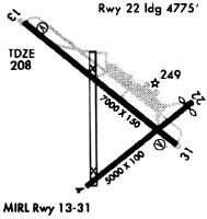
Runway Summary
| Runways: | 04/22 13/31 |
| Longest Runway: | 13/31 is 7000 ft (2134 m) long |
| Runways with an Instrument Approach: | 13 |
KGNF Airport Runway Details
| Runway 04/22 | 4998 ft x 99 ft (1523 m x 30 m) | |
| Runway Length Source: | NGS as of 02/28/2010 | |
| Surface: | Asphalt - Poor condition - No special surface treatment | |
Runway Weight Bearing Capacity (in thousands of pounds) |
||
| Single Wheel Landing Gear: | 60.0 | |
| Dual Wheel Landing Gear: | 200.0 | |
| Dual Tandem Wheel Landing Gear: | 300.0 | |
Runway 04 |
Runway 22 |
|
Elevation: |
192.9 | 201.3 |
Latitude: |
33-49-28.5735N | 33-49-59.1184N |
Longitude: |
089-48-07.8345W | 089-47-21.2419W |
|
Runway True Alignment: |
052 | 232 |
Glide Path Angle: |
0.0 degrees | 0.0 degrees |
Traffic Pattern: |
Left | Left |
Runway Markings Type: |
Basic | Basic |
Runway Markings Condition: |
Poor | Poor |
Object at End: |
TREES | ROAD |
Object Height: |
59 | 15 |
Distance from End: |
1350 | 200 |
Object Centerline Offset: |
0 ft. left and right of centerline | 225 ft. right of centerline |
Threshold Elevation: |
200.8 | |
Displaced Threshold: |
272 | |
Threshold Latitude: |
33-49-57.4556N | |
Threshold Longitude: |
089-47-23.7786W |
| Runway 13/31 | 7000 ft x 150 ft (2134 m x 46 m) | |
| Runway Length Source: | NGS as of 02/28/2010 | |
| Surface: | Asphalt - Poor condition - No special surface treatment | |
| Runway Edge Lights: | Medium Intensity | |
Runway Weight Bearing Capacity (in thousands of pounds) |
||
| Single Wheel Landing Gear: | 60.0 | |
| Dual Wheel Landing Gear: | 200.0 | |
| Dual Tandem Wheel Landing Gear: | 300.0 | |
Runway 13 |
Runway 31 |
|
Elevation: |
207.6 | 197.8 |
Latitude: |
33-50-29.1453N | 33-49-42.9718N |
Longitude: |
089-48-30.7067W | 089-47-28.8597W |
|
Runway True Alignment: |
132 | 312 |
ILS Type: |
ILS/DME | |
Glide Path Angle: |
3.0 degrees | 3.0 degrees |
Traffic Pattern: |
Left | Left |
Runway Markings Type: |
Precision Instrument | Precision Instrument |
Runway Markings Condition: |
Fair | Fair |
Object at End: |
TREES | |
Object Height: |
76 | |
Distance from End: |
2350 | |
Object Centerline Offset: |
0 ft. left and right of centerline | 225 ft. right of centerline |
Visual Glide Slope Indicators: |
4-Box VASI On Left Side Of Runway | 4-Box VASI On Left Side Of Runway |
Approach Light System: |
1,400 Foot Medium Intensity Approach Lighting System With Runway Alignment Indicator Lights | |
Threshold Crossing Height: |
52 | 56 |
Services
Bottled Oxygen: |
None |
Bulk Oxygen: |
None |
Fuel Available: |
100LL |
Landing Fees: |
No |
Parking: |
Tiedowns available |
Maps & Diagrams
KGNF Sectional
Flight Planning
at skyvector.com
at skyvector.com