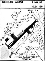
Location
Latitude: |
57-48-21.3030N (57.805918) |
Longitude: |
152-22-25.8290W (-152.373841) |
Elevation: |
139.0 feet MSL (42 m MSL) |
Magnetic Variation: |
13.7 E (as of April 2024 from WMM2020 model) |
Time Zone: |
UTC -9.0 (Standard Time) UTC -8.0 (Daylight Savings Time) |
From City: |
02 N.M. NE of Kodiak, Alaska |
Found On: |
Kodiak Chart |
FAA Region: |
AAL |
Contacts
Manager: |
Publicly owned: |
| CRAIG WALTON 2410 MILL BAY ROAD KODIAK, AK 99615 907-486-8060 |
CITY OF KODIAK PUBLIC WORKS 2410 MILL BAY ROAD KODIAK, AK 99615 907-486-8060 |
Operations
Airport Status: |
Operational |
Facility Use: |
Public |
Type: |
Airport |
Activation Date: |
05/1962 |
Control tower: |
No |
Attendance (Months/Days/Hours): |
Months/Days/Hours ALL/ALL/DALGT |
Boundary ARTCC: |
ZAN (Anchorage) |
Responsible ARTCC: |
ZAN (Anchorage) |
Segmented Circle Indicator: |
No |
Traffic Pattern Altitude (MSL): |
1139 feet (347 m) |
NOTAMs Facility: |
ENA |
NOTAM-D Service: |
Yes |
International Airport of Entry: |
No |
Customs Landing Rights: |
No |
Military Landing Rights: |
Yes |
Civil/Military Joint Use: |
No |
Based Aircraft
| Single Engine: | 14 |
Annual Operations (as of 12/31/2021)
| Total Operations: | 300 | |
| GA Local: | 300 | 100.0% |
Communications
| CTAF: | 119.800 |
| Unicom: | 122.800 |
Fixed Based Operators (FBOs) & Fuel
(Click on a business for detail)
Please help us keep this information up to date. This is a FREE SERVICE just like everything else on Airport Guide! If you see that a business needs to be added, modified, or deleted please fill out our Update Form.
To add, modify, or delete a business click here.
Please help us keep this information up to date. This is a FREE SERVICE just like everything else on Airport Guide! If you see that a business needs to be added, modified, or deleted please fill out our Update Form.
Area Code: 907 |
| Business Name | Frequency | Phone | Fuel Grade |
|---|---|---|---|
| City of Kodiak
Update FBO info |
486-8085 | ||
| Island Air Service
Update FBO info |
Unicom 122.8 | 486-6196 |
Flight Service Stations
| Primary | Alternate | |
| FSS on Field: | N | |
| FSS Name (ID): | Kenai(ENA) | |
| Frequency: | ||
| Toll Free Phone: | 1-866-864-1737 |
Instrument Procedures / Charts
Terminal Procedures are only available for airports in several countries with more being added all the time. If you are looking for a specific country's charts, please send an email to support(at)airportguide.com stating the country name. This will be used to prioritize the implementation.
Navigation Aids (Navaids) near KDK
Nearby Airports with Fuel
| Dist (NM) | Name (Airport IDs) | True Hdg | Mag Hdg | Fuel Grade |
|---|---|---|---|---|
| 0.3 | Kodiak /Lilly Lake/ Seaplane Base (9Z3) |
234 | 220 | 100LL |
Notices to Airmen (NOTAMS)
Remarks
| A110-1 | CONFLICTING TFC WITH LILLY LAKE, TRIDENT BASIN, & KODIAK ARPT. |
| A110-10 | ARPT UNLIT AND CLSD FOR NIGHT OPERS. |
| A110-2 | RY 20 ROAD CROSSES APCH 15 FT BELOW THR ELEVATION 200 FT FM RY THR. |
| A110-3 | RY SLOPES UPHILL 67 FT FM RY 02 DSPLCD THLD TO RY 20; NO LINE OF SIGHT BTN RY ENDS. FIRST 350 FT OF RY 02 SLOPES 5% UPHILL. |
| A110-4 | RY 02/20 SURROUNDED BY NUMEROUS BUSINESSES IN CLOSE PROXIMITY. |
| A110-5 | ARPT CLSD HI/LOW WING EXCP 49 FT/UNDER. |
| A110-6 | NUMEROUS UNLIT OBSTNS IN VCNTY. |
| A110-8 | KODIAK WX CAMERA AVBL ON INTERNET AT HTTPS://WEATHERCAMS.FAA.GOV |
| A33-02/20 | PAVEMENT WIDTH VARIES FROM 20 FT WIDE ON RY 20 END TO 30 FT WIDE ON RY 02 END. PAVEMENT IS CRACKED LENGTH OF RWY. |
| A42-02 | RY 02/20 NSTD MKGS FADED TO INVISIBLE. |
| A52-02 | ACCESS ROAD CROSSES THE APCH END OF RY 02 AND THEN PARALLELS RY TO RAMP. |
| A52-20 | ACCESS ROAD PARALLELS RY TO RAMP AREA. |
| A58-02 | RY 02 +15 FT ROAD 0 FT FM RY END 60 FT L OF CNTRLN. |
| A58-20 | RY 20 +15 FT ROAD 0 FT FM RY END 60 FT R OF CNTRLN. |
| A82 | CTC KODIAK TWR FOR TFC ADVISORY - 119.8. |
| E111 | NOT RQRD UNDER FAR 157. |
Runways
Runway Summary
| Runways: | 02/20 |
| Longest Runway: | 02/20 is 2475 ft (754 m) long |
| Runways with an Instrument Approach: |
KDK Seaplane Base Runway Details
| Runway 02/20 | 2475 ft x 40 ft (754 m x 12 m) | |
| Surface: | Asphalt/Treated - Fair condition - No special surface treatment | |
Runway 02 |
Runway 20 |
|
Glide Path Angle: |
0.0 degrees | 0.0 degrees |
Traffic Pattern: |
Right | Left |
Runway Markings Type: |
Nonstandard (other than numbers only) | Nonstandard (other than numbers only) |
Runway Markings Condition: |
Poor | Poor |
Object at End: |
TREE | TREES |
Object Height: |
80 | 75 |
Distance from End: |
1090 | 2112 |
Object Centerline Offset: |
190 ft. right of centerline | 125 ft. left and right of centerline |
Displaced Threshold: |
240 |
Services
Airframe Repair: |
None |
Powerplant Repair: |
None |
Bottled Oxygen: |
None |
Bulk Oxygen: |
None |
Fuel Available: |
100LL |
Landing Fees: |
No |
Maps & Diagrams
KDK Sectional
Flight Planning
at skyvector.com
at skyvector.com