Location
Latitude: |
39-50-25.2186N (39.840338) |
Longitude: |
101-02-32.9385W (-101.042483) |
Elevation: |
2990.7 feet MSL (912 m MSL) |
Magnetic Variation: |
5.4 E (as of April 2024 from WMM2020 model) |
Time Zone: |
UTC -6.0 (Standard Time) UTC -5.0 (Daylight Savings Time) |
From City: |
02 N.M. N of Atwood, Kansas |
Found On: |
Wichita Chart |
FAA Region: |
ACE |
Contacts
Manager: |
Publicly owned: |
| CHRIS TIEMEYER 12323 HWY 25 ATWOOD, KS 67730 (785) 626-0297 |
CITY OF ATWOOD & RAWLINS CO. ATWOOD, KS 67730 785-626-3344 |
Operations
Airport Status: |
Operational |
Facility Use: |
Public |
Type: |
Airport |
Activation Date: |
12/1946 |
Control tower: |
No |
Attendance (Months/Days/Hours): |
Months/Days/Hours Unattended |
Boundary ARTCC: |
ZDV (Denver) |
Responsible ARTCC: |
ZDV (Denver) |
Lighting Schedule: |
SEE RMK |
Segmented Circle Indicator: |
Yes |
Traffic Pattern Altitude (MSL): |
3991 feet (1216 m) |
NOTAMs Facility: |
ICT |
NOTAM-D Service: |
Yes |
Civil/Military Joint Use: |
No |
Based Aircraft
| Single Engine: | 13 |
| Multi Engine: | 1 |
Annual Operations (as of 09/16/2018)
| Total Operations: | 12000 | |
| GA Local: | 8000 | 66.7% |
| GA Itinerant: | 4000 | 33.3% |
Communications
| CTAF: | 122.700 |
| Unicom: | 122.700 |
| AWOS-3: | 118.675 (785-626-3572) |
- APCH/DEP CTL SVC PRVDD BY DENVER ARTCC (ZDV) ON FREQS 132.7/226.675 (GOODLAND RCAG).
Fixed Based Operators (FBOs) & Fuel
(Click on a business for detail)
Please help us keep this information up to date. This is a FREE SERVICE just like everything else on Airport Guide! If you see that a business needs to be added, modified, or deleted please fill out our Update Form.
To add, modify, or delete a business click here.
Please help us keep this information up to date. This is a FREE SERVICE just like everything else on Airport Guide! If you see that a business needs to be added, modified, or deleted please fill out our Update Form.
Area Code: 785 |
| Business Name | Frequency | Phone | Fuel Grade |
|---|---|---|---|
| Gray Aviation, Inc.
Update FBO info |
626-3245 | 100LL | |
| Sunflower Aero
Update FBO info |
626-3344 | 100LL |
Flight Service Stations
| Primary | Alternate | |
| FSS on Field: | N | |
| FSS Name (ID): | Wichita(ICT) | |
| Frequency: | ||
| Toll Free Phone: | 1-800-WX-BRIEF |
Instrument Procedures / Charts
FAA Terminal Procedures valid from 0901Z 03/21/24 to 0901Z 04/18/24.
There are various types of charts available for an airport. They are listed in the Page Type column. Here is a legend for those types:
APD - Airport Diagram
DP - Departure Procedure Charts
HOT - Hot Spots
IAP - Instrument Approach Procedure Charts
MIN - Minimums
STAR - Standard Terminal Arrival Charts
| Page Type | Page Name | Volume | Action Since Last Cycle |
|---|---|---|---|
| IAP | RNAV (GPS) RWY 17 | NC-2 | |
| MIN | TAKEOFF MINIMUMS | NC-2 |
Terminal Procedures are only available for airports in several countries with more being added all the time. If you are looking for a specific country's charts, please send an email to support(at)airportguide.com stating the country name. This will be used to prioritize the implementation.
Navigation Aids (Navaids) near KADT
| Dist (NM) | ID | Morse Code | Name | Type | Freq | True Hdg | Mag Hdg |
|---|---|---|---|---|---|---|---|
| 19.8 | JDM | . _ _ _ _ . . _ _ | Wheatfield | NDB | 408 | 180 | 175 |
| 23.3 | OIN | _ _ _ . . _ . | Oberlin | NDB | 341 | 91 | 86 |
| 30.0 | MCK | _ _ _ . _ . _ . _ | Mc Cook | VOR-DME | 115.30 | 43 | 38 |
| 30.6 | MCK | _ _ _ . _ . _ . _ | Mc Cook | FAN MARKER | 48 | 43 | |
| 34.1 | SYF | . . . _ . _ _ . . _ . | St Francis | NDB | 386 | 258 | 252 |
| 37.2 | HCT | . . . . _ . _ . _ | Hayes Center | VORTAC | 117.70 | 8 | 3 |
| 40.5 | GLD | _ _ . . _ . . _ . . | Goodland | VORTAC | 115.10 | 228 | 222 |
| 41.7 | GL | _ _ . . _ . . | Shugr | NDB | 414 | 218 | 212 |
| 44.9 | OEL | _ _ _ . . _ . . | Oakley | NDB | 380 | 166 | 161 |
| 49.2 | CSB | _ . _ . . . . _ . . . | Harry Strunk | NDB | 389 | 55 | 50 |
| 51.4 | HLC | . . . . . _ . . _ . _ . | Hill City | VORTAC | 113.70 | 132 | 127 |
| 53.1 | NRN | _ . . _ . _ . | Norton | NDB | 230 | 88 | 83 |
| 67.6 | ITR | . . _ . _ . | Kit Carson | NDB | 209 | 238 | 232 |
| 69.4 | GGF | _ _ . _ _ . . . _ . | Grant | NDB | 359 | 333 | 327 |
| 73.7 | LBF | . _ . . _ . . . . . _ . | North Platte | VOR-DME | 117.40 | 10 | 5 |
| 76.2 | DWL | _ . . . _ _ . _ . . | Willow | NDB | 353 | 35 | 30 |
| 76.7 | LB | . _ . . _ . . . | Panbe | NDB | 416 | 16 | 11 |
| 77.9 | OZB | _ _ _ _ _ . . _ . . . | Cozad | VOR | 109.00 | 37 | 32 |
| 81.1 | RRX | . _ . . _ . _ . . _ | Darr | NDB | 326 | 41 | 36 |
| 81.3 | PHG | . _ _ . . . . . _ _ . | Phillipsburg | NDB | 368 | 95 | 90 |
Nearby Airports with Fuel
Notices to Airmen (NOTAMS)
Remarks
| A110-1 | PUBLIC PHONE AVBL 24 HRS. |
| A110-2 | FOR CD CTC DENVER ARTCC AT 303-651-4257. |
| A33-04/22 | ACUTE DIFFERENCE IN SFC ELEV AT INT WITH RWY 17 & 35. SUG OPS BE CONDUCTED E OF THAT INT. |
| A70-FUEL-10 | 0LL 24 HR SELF-SERVE FUEL. |
| A81-APT | ACTVT REIL RWY 17 & 35; PAPI RWYS RWY 17 & 35; MIRL RWY 17/35 - CTAF. |
| A83 | LGTD WIND CONES LCTD 1000 FT FM AER 17 & 35, LEFT SIDE. |
| E111 | EXISTED PRIOR TO 1959. |
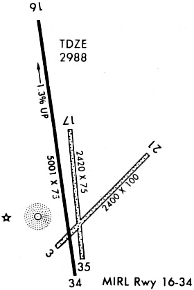
Runways
Runway Summary
| Runways: | 04/22 17/35 |
| Longest Runway: | 17/35 is 5000 ft (1524 m) long |
| Runways with an Instrument Approach: |
KADT Airport Runway Details
| Runway 04/22 | 2400 ft x 100 ft (732 m x 30 m) | |
| Runway Length Source: | 3RD PARTY SURVEY as of 07/22/2011 | |
| Surface: | Turf - Good condition - No special surface treatment | |
Runway 04 |
Runway 22 |
|
Elevation: |
2929.5 | 2946.3 |
Latitude: |
39-50-08.6965N | 39-50-25.3210N |
Longitude: |
101-02-38.1586W | 101-02-16.2154W |
|
Runway True Alignment: |
046 | 226 |
Glide Path Angle: |
0.0 degrees | 0.0 degrees |
Traffic Pattern: |
Left | Left |
Runway Markings Type: |
None | None |
Runway Markings Condition: |
Fair | Fair |
Object at End: |
PLINE | |
Object Height: |
28 | |
Object Marked/Lighted?: |
Marked | |
Distance from End: |
950 | |
Object Centerline Offset: |
0 ft. left and right of centerline |
| Runway 17/35 | 5000 ft x 75 ft (1524 m x 23 m) | |
| Runway Length Source: | 3RD PARTY SURVEY as of 07/22/2011 | |
| Surface: | Turf - Good condition - No special surface treatment | |
| Runway Edge Lights: | Medium Intensity | |
Runway Weight Bearing Capacity (in thousands of pounds) |
||
| Single Wheel Landing Gear: | 12.5 | |
| Dual Wheel Landing Gear: | 12.5 | |
Runway 17 |
Runway 35 |
|
Elevation: |
2990.7 | 2926.7 |
Latitude: |
39-50-53.6788N | 39-50-04.6398N |
Longitude: |
101-02-39.5524W | 101-02-31.8460W |
|
Runway True Alignment: |
173 | 353 |
Glide Path Angle: |
3.0 degrees | 3.0 degrees |
Runway Markings Type: |
Nonprecision Instrument | Nonprecision Instrument |
Runway Markings Condition: |
Good | Good |
Object Centerline Offset: |
0 ft. left and right of centerline | |
Visual Glide Slope Indicators: |
2-Light PAPI On Left Side Of Runway | 2-Light PAPI On Right Side Of Runway |
REIL: |
Yes | Yes |
Threshold Crossing Height: |
40 | 40 |
Services
Bottled Oxygen: |
None |
Bulk Oxygen: |
None |
Fuel Available: |
100LL |
Landing Fees: |
No |
Parking: |
Tiedowns available |
Maps & Diagrams
KADT Sectional
Flight Planning
at skyvector.com
at skyvector.com