Location
Latitude: |
37-09-11.4020N (37.153167) |
Longitude: |
094-29-55.7070W (-94.498808) |
Elevation: |
977.9 feet MSL (298 m MSL) |
Magnetic Variation: |
1.2 E (as of April 2024 from WMM2020 model) |
Time Zone: |
UTC -6.0 (Standard Time) UTC -5.0 (Daylight Savings Time) |
From City: |
04 N.M. N of Joplin, Missouri |
Found On: |
Kansas City Chart |
FAA Region: |
ACE |
Contacts
Manager: |
Publicly owned: |
| MR. BART STARKEY 602 S. MAIN STREET JOPLIN, MO 64802 417-623-0262 |
CITY OF JOPLIN 602 S. MAIN STREET JOPLIN, MO 64802-1355 417-624-0820 |
Operations
Airport Status: |
Operational |
Facility Use: |
Public |
Type: |
Airport |
Activation Date: |
04/1940 |
Control tower: |
Yes |
Attendance (Months/Days/Hours): |
Months/Days/Hours ALL/ALL/0500-0000 |
Boundary ARTCC: |
ZKC (Kansas City) |
Responsible ARTCC: |
ZKC (Kansas City) |
Lighting Schedule: |
SEE RMK |
Segmented Circle Indicator: |
No |
Traffic Pattern Altitude (MSL): |
1978 feet (603 m) |
NOTAMs Facility: |
JLN |
NOTAM-D Service: |
Yes |
International Airport of Entry: |
No |
Customs Landing Rights: |
No |
Military Landing Rights: |
Yes |
Civil/Military Joint Use: |
No |
Aircraft Rescue and Firefighting: |
Class I ARFF Index: A Air Carrier Service: Scheduled Certification Date: 05/1973 |
Based Aircraft
| Single Engine: | 107 |
| Multi Engine: | 12 |
| Jet Engine: | 9 |
Annual Operations (as of 12/31/2023)
| Total Operations: | 21818 | |
| Commercial: | 2 | 0.0% |
| Air Taxi: | 1236 | 5.7% |
| GA Local: | 8150 | 37.4% |
| GA Itinerant: | 12177 | 55.8% |
| Military Aircraft: | 253 | 1.2% |
Communications
| CTAF: | 119.800 |
| Unicom: | 122.950 |
| Tower: | JOPLIN 119.8 Hrs: 0600-2100 |
| Ground: | 121.6 |
| Approach: | KANSAS CITY ARTCC |
| Departure: | KANSAS CITY ARTCC |
| ATIS: | 120.85 Hrs: 24 |
| ASOS: | (417-623-8892) |
- APCH/DEP SVC PRVDD BY KANSAS CITY ARTCC ON FREQS 128.6/282.325 (EDNA RCAG).
Fixed Based Operators (FBOs) & Fuel
(Click on a business for detail)
Please help us keep this information up to date. This is a FREE SERVICE just like everything else on Airport Guide! If you see that a business needs to be added, modified, or deleted please fill out our Update Form.
To add, modify, or delete a business click here.
Please help us keep this information up to date. This is a FREE SERVICE just like everything else on Airport Guide! If you see that a business needs to be added, modified, or deleted please fill out our Update Form.
Area Code: 417 |
| Business Name | Frequency | Phone | Fuel Grade |
|---|---|---|---|
| Mizzou Aviation
Update FBO info |
Unicom 122.95 | 623-1331 | 100LL, Jet A |
Flight Service Stations
| Primary | Alternate | |
| FSS on Field: | N | |
| FSS Name (ID): | Columbia(COU) | |
| Frequency: | ||
| Toll Free Phone: | 1-800-WX-BRIEF |
Instrument Procedures / Charts
FAA Terminal Procedures valid from 0901Z 03/21/24 to 0901Z 04/18/24.
There are various types of charts available for an airport. They are listed in the Page Type column. Here is a legend for those types:
APD - Airport Diagram
DP - Departure Procedure Charts
HOT - Hot Spots
IAP - Instrument Approach Procedure Charts
MIN - Minimums
STAR - Standard Terminal Arrival Charts
| Page Type | Page Name | Volume | Action Since Last Cycle |
|---|---|---|---|
| APD | AIRPORT DIAGRAM | NC-3 | |
| HOT | HOT SPOT | NC-3 | |
| IAP | ILS OR LOC RWY 13 | NC-3 | |
| IAP | ILS OR LOC RWY 18 | NC-3 | |
| IAP | RNAV (GPS) RWY 13 | NC-3 | |
| IAP | RNAV (GPS) RWY 18 | NC-3 | |
| IAP | RNAV (GPS) RWY 31 | NC-3 | |
| IAP | RNAV (GPS) RWY 36 | NC-3 | |
| MIN | ALTERNATE MINIMUMS | NC-3 | |
| MIN | TAKEOFF MINIMUMS | NC-3 |
Terminal Procedures are only available for airports in several countries with more being added all the time. If you are looking for a specific country's charts, please send an email to support(at)airportguide.com stating the country name. This will be used to prioritize the implementation.
Navigation Aids (Navaids) near JLN
| Dist (NM) | ID | Morse Code | Name | Type | Freq | True Hdg | Mag Hdg |
|---|---|---|---|---|---|---|---|
| 4.1 | JL | . _ _ _ . _ . . | Lunns | NDB | 344 | 316 | 315 |
| 18.9 | EOS | . _ _ _ . . . | Neosho | DME | 117.3 | 170 | 169 |
| 20.5 | PTS | . _ _ . _ . . . | Pittsburg | NDB | 365 | 328 | 327 |
| 22.1 | LLU | . _ . . . _ . . . . _ | Spring River | NDB | 356 | 24 | 23 |
| 33.7 | OSW | _ _ _ . . . . _ _ | Oswego | DME | 117.6 | 270 | 269 |
| 40.7 | FSK | . . _ . . . . _ . _ | Fort Scott | NDB | 379 | 341 | 340 |
| 46.4 | RO | . _ . _ _ _ | Rogrs | NDB | 263 | 153 | 152 |
| 51.4 | CFV | _ . _ . . . _ . . . . _ | Coffeyville | NDB | 212 | 266 | 264 |
| 56.9 | SGF | . . . _ _ . . . _ . | Springfield | VORTAC | 116.90 | 77 | 76 |
| 57.4 | RZC | . _ . _ _ . . _ . _ . | Razorback | VORTAC | 116.40 | 161 | 160 |
| 57.8 | SLG | . . . . _ . . _ _ . | Siloam Springs | NDB | 284 | 179 | 178 |
| 58.1 | MSB | _ _ . . . _ . . . | Monarch | NDB | 410 | 311 | 310 |
| 59.4 | CNU | _ . _ . _ . . . _ | Chanute | VOR-DME | 109.20 | 298 | 296 |
| 67.1 | BUM | _ . . . . . _ _ _ | Butler | VORTAC | 115.90 | 0 | 359 |
| 68.2 | DAK | _ . . . _ _ . _ | Drake | DME | 115.25 | 167 | 166 |
| 75.0 | BV | _ . . . . . . _ | Dewie | NDB | 201 | 255 | 253 |
| 75.3 | BVO | _ . . . . . . _ _ _ _ | Bartlesville | VOR-DME | 117.90 | 255 | 253 |
| 77.5 | TQH | _ _ _ . _ . . . . | Tahlequah | NDB | 215 | 198 | 197 |
| 78.0 | DGD | _ . . _ _ . _ . . | Dogwood | VORTAC | 109.40 | 95 | 94 |
| 79.6 | HRO | . . . . . _ . _ _ _ | Harrison | VOR-DME | 112.50 | 128 | 127 |
Nearby Airports with Fuel
Notices to Airmen (NOTAMS)
Remarks
| A110-1 | BIRDS ON & INVOF ARPT SPRING & FALL. |
| A110-2 | PPR 48 HRS FOR ACFT CARRYING HAZARDOUS OR EXPLOSIVE CARGO. |
| A110-3 | FOR CD IF UNA TO CTC ON FSS FREQ, CTC KANSAS CITY ARTCC AT 913-254-8508. |
| A26 | PPR 48 HRS FOR UNSKED ACR OPNS WITH MORE THAN 30 PSGR SEATS CALL AMGR 417-623-0262. |
| A57-13 | APCH RATIO FROM DSPLCD THR 33:1 |
| A57-31 | APCH RATIO FROM DSPLCD THR 32:1 |
| A81-APT | WHEN ATCT CLSD ACTVT MALSF RWY 13; ODALS RWY 31; HIRL RWY 13/31 - CTAF. MALSR RWY 18; PAPI RWY 31; HIRL RWY 18/36 - OPR DUSK-DAWN. |
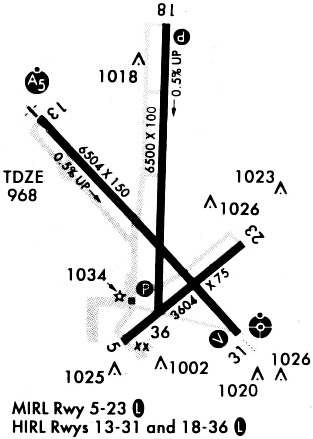
Runways
Runway Summary
| Runways: | 13/31 18/36 |
| Longest Runway: | 18/36 is 6502 ft (1982 m) long |
| Runways with an Instrument Approach: | 13, 18 |
JLN Airport Runway Details
| Runway 13/31 | 6501 ft x 150 ft (1982 m x 46 m) | |
| Runway Length Source: | 3RD PARTY SURVEY as of 04/27/2022 | |
| Surface: | Asphalt - Good condition - Saw-cut or plastic grooved | |
| Runway Pavement Class: | 40 /F/C/X/U | |
| Runway Edge Lights: | High Intensity | |
Runway Weight Bearing Capacity (in thousands of pounds) |
||
| Single Wheel Landing Gear: | 80.0 | |
| Dual Wheel Landing Gear: | 105.0 | |
| Dual Tandem Wheel Landing Gear: | 170.0 | |
Runway 13 |
Runway 31 |
|
Elevation: |
947.2 | 976.7 |
Latitude: |
37-09-28.1123N | 37-08-40.3695N |
Longitude: |
094-30-26.2569W | 094-29-32.5070W |
|
Runway True Alignment: |
138 | 318 |
ILS Type: |
ILS | |
Glide Path Angle: |
0.0 degrees | 3.0 degrees |
Traffic Pattern: |
Left | Left |
Runway Markings Type: |
Precision Instrument | Nonprecision Instrument |
Runway Markings Condition: |
Fair | Fair |
Object at End: |
TREE | TREE |
Object Height: |
36 | 47 |
Distance from End: |
825 | 1200 |
Object Centerline Offset: |
490 ft. right of centerline | 300 ft. left of centerline |
Visual Glide Slope Indicators: |
4-Light PAPI On Left Side Of Runway | |
Runway Visual Range (RVR): |
Touchdown | |
Approach Light System: |
1,400 Foot Medium Intensity Approach Lighting System With Sequenced Flashers | Omnidirectional Approach Lighting System |
Threshold Crossing Height: |
47 | |
Threshold Elevation: |
951.1 | 977.9 |
Displaced Threshold: |
388 | 299 |
Threshold Latitude: |
37-09-25.2621N | 37-08-42.5638N |
Threshold Longitude: |
094-30-23.0470W | 094-29-34.9803W |
Declared Distances |
||
Take Off Run Avbl. (TORA): |
6500 | 6500 |
Take Off Distance Avbl. (TODA): |
6500 | 6500 |
Actual Stop Dist. Avbl. (ASDA): |
6201 | 6112 |
Landing Dist. Avbl. (LDA): |
5813 | 5813 |
| Runway 18/36 | 6502 ft x 100 ft (1982 m x 30 m) | |
| Runway Length Source: | 3RD PARTY SURVEY as of 04/27/2022 | |
| Surface: | Asphalt - Good condition - No special surface treatment | |
| Runway Pavement Class: | 13 /F/C/X/T | |
| Runway Edge Lights: | High Intensity | |
Runway Weight Bearing Capacity (in thousands of pounds) |
||
| Single Wheel Landing Gear: | 30.0 | |
| Dual Wheel Landing Gear: | 60.0 | |
Runway 18 |
Runway 36 |
|
Elevation: |
949.4 | 971.1 |
Latitude: |
37-09-50.6825N | 37-08-46.4398N |
Longitude: |
094-29-50.6591W | 094-29-53.4097W |
|
Runway True Alignment: |
182 | 002 |
ILS Type: |
ILS/DME | |
Glide Path Angle: |
0.0 degrees | 0.0 degrees |
Traffic Pattern: |
Left | Left |
Runway Markings Type: |
Precision Instrument | Nonprecision Instrument |
Runway Markings Condition: |
Fair | Fair |
Object at End: |
POLE | |
Object Height: |
15 | |
Distance from End: |
675 | |
Object Centerline Offset: |
490 ft. right of centerline | 300 ft. left of centerline |
Runway Visual Range (RVR): |
Touchdown | Rollout |
Approach Light System: |
1,400 Foot Medium Intensity Approach Lighting System With Runway Alignment Indicator Lights | |
Declared Distances |
||
Take Off Run Avbl. (TORA): |
6499 | 6499 |
Take Off Distance Avbl. (TODA): |
6499 | 6499 |
Actual Stop Dist. Avbl. (ASDA): |
6499 | 6499 |
Landing Dist. Avbl. (LDA): |
6499 | 6499 |
Services
Airframe Repair: |
Major |
Powerplant Repair: |
Major |
Bottled Oxygen: |
None |
Bulk Oxygen: |
None |
Fuel Available: |
100LL, Jet A, MOGAS |
Landing Fees: |
No |
Parking: |
Hangars and tiedowns available |
Maps & Diagrams
JLN Sectional
Flight Planning
at skyvector.com
at skyvector.com