Location
Latitude: |
38-10-54.2341N (38.181732) |
Longitude: |
084-54-24.2992W (-84.90675) |
Elevation: |
812.3 feet MSL (248 m MSL) |
Magnetic Variation: |
5.7 W (as of April 2024 from WMM2020 model) |
Time Zone: |
UTC -5.0 (Standard Time) UTC -4.0 (Daylight Savings Time) |
From City: |
01 N.M. SW of Frankfort, Kentucky |
Found On: |
Cincinnati Chart |
FAA Region: |
ASO |
Contacts
Manager: |
Publicly owned: |
| ANTHONY ADAMS 88 AIRPORT ROAD FRANKFORT, KY 40601 502-564-0339 |
COMMONWEALTH OF KENTUCKY 90 AIRPORT RD FRANKFORT, KY 40601 502-564-3714 |
Operations
Airport Status: |
Operational |
Facility Use: |
Public |
Type: |
Airport |
Activation Date: |
07/1954 |
Control tower: |
No |
Attendance (Months/Days/Hours): |
Months/Days/Hours ALL/MON-FRI/0700-2000 |
Boundary ARTCC: |
ZID (Indianapolis) |
Responsible ARTCC: |
ZID (Indianapolis) |
Lighting Schedule: |
SEE RMK |
Segmented Circle Indicator: |
Yes |
Traffic Pattern Altitude (MSL): |
1812 feet (552 m) |
NOTAMs Facility: |
FFT |
NOTAM-D Service: |
Yes |
International Airport of Entry: |
No |
Customs Landing Rights: |
No |
Military Landing Rights: |
Yes |
Civil/Military Joint Use: |
No |
Based Aircraft
| Single Engine: | 43 |
| Multi Engine: | 5 |
| Jet Engine: | 1 |
| GA Helicopters: | 7 |
| Military Aircraft: | 3 |
| Ultralights: | 1 |
Annual Operations (as of 06/20/2022)
| Total Operations: | 39216 | |
| Air Taxi: | 3570 | 9.1% |
| GA Local: | 10450 | 26.6% |
| GA Itinerant: | 20196 | 51.5% |
| Military Aircraft: | 5000 | 12.7% |
Communications
| CTAF: | 122.800 |
| Unicom: | 122.800 |
| Clearance Del.: | 118.65 118.65 118.65 |
| Approach: | LEXINGTON |
| Departure: | LEXINGTON |
| ASOS: | 119.275 (502-227-5087) |
Fixed Based Operators (FBOs) & Fuel
(Click on a business for detail)
Please help us keep this information up to date. This is a FREE SERVICE just like everything else on Airport Guide! If you see that a business needs to be added, modified, or deleted please fill out our Update Form.
To add, modify, or delete a business click here.
Please help us keep this information up to date. This is a FREE SERVICE just like everything else on Airport Guide! If you see that a business needs to be added, modified, or deleted please fill out our Update Form.
Area Code: 502 |
| Business Name | Frequency | Phone | Fuel Grade |
|---|---|---|---|
| Commonwealth of Kentucky
Update FBO info |
Unicom 122.8 | 564-3714 | 80, 100LL, Jet A |
Flight Service Stations
| Primary | Alternate | |
| FSS on Field: | N | |
| FSS Name (ID): | Louisville(LOU) | |
| Frequency: | ||
| Toll Free Phone: | 1-800-WX-BRIEF |
Instrument Procedures / Charts
FAA Terminal Procedures valid from 0901Z 03/21/24 to 0901Z 04/18/24.
There are various types of charts available for an airport. They are listed in the Page Type column. Here is a legend for those types:
APD - Airport Diagram
DP - Departure Procedure Charts
HOT - Hot Spots
IAP - Instrument Approach Procedure Charts
MIN - Minimums
STAR - Standard Terminal Arrival Charts
| Page Type | Page Name | Volume | Action Since Last Cycle |
|---|---|---|---|
| IAP | LOC RWY 25 | SE-1 | |
| IAP | RNAV (GPS) RWY 07 | SE-1 | |
| IAP | RNAV (GPS) RWY 25 | SE-1 | |
| IAP | VOR RWY 25 | SE-1 | |
| MIN | ALTERNATE MINIMUMS | SE-1 | |
| MIN | TAKEOFF MINIMUMS | SE-1 |
Terminal Procedures are only available for airports in several countries with more being added all the time. If you are looking for a specific country's charts, please send an email to support(at)airportguide.com stating the country name. This will be used to prioritize the implementation.
Navigation Aids (Navaids) near FFT
| Dist (NM) | ID | Morse Code | Name | Type | Freq | True Hdg | Mag Hdg |
|---|---|---|---|---|---|---|---|
| 0.1 | FFT | . . _ . . . _ . _ | Frankfort | VOR | 109.40 | 294 | 300 |
| 16.5 | LE | . _ . . . | Blayd | NDB | 242 | 135 | 141 |
| 19.2 | GN | _ _ . _ . | Bridl | NDB | 340 | 100 | 106 |
| 24.2 | HYK | . . . . _ . _ _ _ . _ | Lexington | VOR-DME | 112.60 | 122 | 128 |
| 32.0 | IIU | . . . . . . _ | Louisville | VORTAC | 114.80 | 261 | 266 |
| 33.8 | BRY | _ . . . . _ . _ . _ _ | Bardstown/Dcmsnd | NDB | 248 | 233 | 238 |
| 34.4 | LK | . _ . . _ . _ | Laang | NDB | 414 | 266 | 271 |
| 35.9 | BQM | _ . . . _ _ . _ _ _ | Bowman | DME | 112.2 | 274 | 279 |
| 36.4 | IKY | . . _ . _ _ . _ _ | Springfield | NDB | 429 | 205 | 211 |
| 36.9 | DVK | _ . . . . . _ _ . _ | Goodall | NDB | 311 | 169 | 175 |
| 39.2 | SDF | . . . _ . . . . _ . | Louisville Standifd | VOT | 111.00 | 270 | 275 |
| 39.7 | FLM | . . _ . . _ . . _ _ | Falmouth | VOR-DME | 117.00 | 44 | 50 |
| 42.1 | ABB | . _ _ . . . _ . . . | Nabb | VORTAC | 112.40 | 305 | 310 |
| 42.8 | JV | . _ _ _ . . . _ | Catch | NDB | 331 | 294 | 299 |
| 43.6 | GVR | _ _ . . . . _ . _ . | Hanover | DME | 114.65 | 322 | 328 |
| 44.3 | IOB | . . _ _ _ _ . . . | Mount Sterling | NDB | 210 | 99 | 105 |
| 48.6 | XYC | _ . . _ _ . _ _ _ . _ . | Seco | NDB | 393 | 121 | 127 |
| 49.1 | EWO | . . _ _ _ _ _ | New Hope | VOR-DME | 113.95 | 228 | 233 |
| 49.4 | TYC | _ _ . _ _ _ . _ . | Taylor County | NDB | 272 | 198 | 204 |
| 51.0 | CVG | _ . _ . . . . _ _ _ . | Cincinnati | VORTAC | 117.30 | 10 | 16 |
Nearby Airports with Fuel
Notices to Airmen (NOTAMS)
Remarks
| A110-1 | CAUTION: DANIEL BOONE HELI 1/2 NM N OF RWY 25 THR; MIL HEL TFC OPS N OF RWY. |
| A110-10 | CTC ANG OPS 42.25/139.35/226.6. |
| A110-5 | DEER & BIRDS ON & INVOF ARPT. |
| A110-6 | MIL HEL USE RIGHT BASE TO RWY 25. |
| A110-7 | PVT AP WITH TURF RWY LCTD 3/4 NM NW OF RWY 07 THR. |
| A110-8 | NOISE ABATEMENT PROCS: RWY 7 DEPG ACFT MNTN RWY HDG TO 1800 FT MSL BFR TURNING. |
| A110-9 | MILITARY: ARNG OPS - UHF FREQ 226.55 |
| A16 | MANAGER'S CELL (502) 545-8111 |
| A43-25 | PAPI RWY 25 UNUSBL BYD 8 DEGS RIGHT OF CNTRLN. |
| A81-APT | ACTVT REIL RWY 07 & 25; PAPI RWY 07 & 25; MIRL RWY 07/25 - CTAF. |
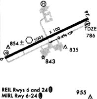
Runways
Runway Summary
| Runways: | 07/25 |
| Longest Runway: | 07/25 is 5506 ft (1678 m) long |
| Runways with an Instrument Approach: | 25 |
FFT Airport Runway Details
| Runway 07/25 | 5506 ft x 100 ft (1678 m x 30 m) | |
| Runway Length Source: | 3RD PARTY SURVEY as of 03/29/2013 | |
| Surface: | Asphalt - Good condition - No special surface treatment | |
| Runway Pavement Class: | 29 /F/C/X/T | |
| Runway Edge Lights: | Medium Intensity | |
Runway Weight Bearing Capacity (in thousands of pounds) |
||
| Single Wheel Landing Gear: | 76.0 | |
| Dual Wheel Landing Gear: | 100.0 | |
| Dual Tandem Wheel Landing Gear: | 82.0 | |
Runway 07 |
Runway 25 |
|
Elevation: |
812.3 | 783.4 |
Latitude: |
38-10-42.2605N | 38-11-06.2077N |
Longitude: |
084-54-55.2601W | 084-53-53.3383W |
|
Runway True Alignment: |
064 | 244 |
ILS Type: |
LOC/DME | |
Glide Path Angle: |
3.0 degrees | 3.5 degrees |
Traffic Pattern: |
Left | Left |
Runway Markings Type: |
Nonprecision Instrument | Nonprecision Instrument |
Runway Markings Condition: |
Good | Good |
Object at End: |
TREES | TREE |
Object Height: |
66 | 57 |
Distance from End: |
1649 | 1607 |
Object Centerline Offset: |
384 ft. right of centerline | 311 ft. left of centerline |
Visual Glide Slope Indicators: |
4-Light PAPI On Left Side Of Runway | 4-Light PAPI On Left Side Of Runway |
REIL: |
Yes | Yes |
Threshold Crossing Height: |
27 | 31 |
Services
Airframe Repair: |
Minor |
Powerplant Repair: |
Minor |
Bottled Oxygen: |
Low Pressure |
Fuel Available: |
100LL, Jet A-1+ |
Landing Fees: |
No |
Parking: |
Hangars and tiedowns available |
Maps & Diagrams
FFT Sectional
Flight Planning
at skyvector.com
at skyvector.com