Location
Latitude: |
39-25-01.2760N (39.417021) |
Longitude: |
077-22-29.0360W (-77.374732) |
Elevation: |
308.9 feet MSL (94 m MSL) |
Magnetic Variation: |
10.6 W (as of April 2024 from WMM2020 model) |
Time Zone: |
UTC -5.0 (Standard Time) UTC -4.0 (Daylight Savings Time) |
From City: |
00 N.M. E of Frederick, Maryland |
Found On: |
Washington Chart |
FAA Region: |
AEA |
Contacts
Manager: |
Publicly owned: |
| ANDREW MOORE 111 AIRPORT DRIVE EAST FREDERICK, MD 21701 301-600-2201 |
CITY OF FREDERICK 101 N COURT ST FREDERICK, MD 21701 301-600-1380 |
Operations
Airport Status: |
Operational |
Facility Use: |
Public |
Type: |
Airport |
Activation Date: |
12/2003 |
Control tower: |
Yes |
Attendance (Months/Days/Hours): |
Months/Days/Hours ALL/ALL/0700-2100++ |
Boundary ARTCC: |
ZDC (Washington) |
Responsible ARTCC: |
ZDC (Washington) |
Lighting Schedule: |
SEE RMK |
Segmented Circle Indicator: |
Yes |
Traffic Pattern Altitude (MSL): |
1309 feet (399 m) |
NOTAMs Facility: |
FDK |
NOTAM-D Service: |
Yes |
International Airport of Entry: |
No |
Customs Landing Rights: |
No |
Military Landing Rights: |
Yes |
Civil/Military Joint Use: |
No |
Based Aircraft
| Single Engine: | 133 |
| Multi Engine: | 18 |
| Jet Engine: | 14 |
| GA Helicopters: | 11 |
Annual Operations (as of 04/19/2023)
| Total Operations: | 84790 | |
| Air Taxi: | 1648 | 1.9% |
| GA Local: | 52186 | 61.5% |
| GA Itinerant: | 30932 | 36.5% |
| Military Aircraft: | 24 | 0.0% |
Communications
| CTAF: | 132.400 |
| Unicom: | 122.950 |
| Tower: | FREDERICK 132.4 Hrs: 0700-2100 |
| Clearance Del.: | 121.975 |
| Ground: | 127.425 |
| Approach: | POTOMAC |
| Departure: | POTOMAC |
| ATIS: | 124.875 Hrs: 24 |
| AWOS-3: | (301-600-1457) |
- POTOMAC CD 126.9 OR 866-709-4993 (WHEN TWR CLSD).
Fixed Based Operators (FBOs) & Fuel
(Click on a business for detail)
Please help us keep this information up to date. This is a FREE SERVICE just like everything else on Airport Guide! If you see that a business needs to be added, modified, or deleted please fill out our Update Form.
To add, modify, or delete a business click here.
Please help us keep this information up to date. This is a FREE SERVICE just like everything else on Airport Guide! If you see that a business needs to be added, modified, or deleted please fill out our Update Form.
Area Code: 301 |
| Business Name | Frequency | Phone | Fuel Grade |
|---|---|---|---|
| Advanced Helicopter Concepts
Update FBO info |
694-5313 | ||
| Aircraft Owner's and Pilots Association (AOPA)
Website Update FBO info |
Unicom 122.85 | 695-2000, 800-872-2672 | |
| Basic Avionics
Update FBO info |
663-3003, 800-638-2661 | ||
| Frederick Aviation, Inc.
Website Update FBO info |
Unicom 123.0, Arinc 130.27 | 662-8156, 800-545-9393 | 100LL, Jet A |

|
 Exxon |
100LL - 2.68 USD per gallon on 9/24/01 |
Pumps |
|
|
Exxon |
Jet A - 2.37 USD per gallon on 9/24/01 |
Pumps |
| Signature Flight Support
Update FBO info |
Arinc: 130.275 | +1 301 662 8156 |
Flight Service Stations
| Primary | Alternate | |
| FSS on Field: | N | |
| FSS Name (ID): | Leesburg(DCA) | |
| Frequency: | ||
| Toll Free Phone: | 1-800-WX-BRIEF |
Instrument Procedures / Charts
FAA Terminal Procedures valid from 0901Z 03/21/24 to 0901Z 04/18/24.
There are various types of charts available for an airport. They are listed in the Page Type column. Here is a legend for those types:
APD - Airport Diagram
DP - Departure Procedure Charts
HOT - Hot Spots
IAP - Instrument Approach Procedure Charts
MIN - Minimums
STAR - Standard Terminal Arrival Charts
| Page Type | Page Name | Volume | Action Since Last Cycle |
|---|---|---|---|
| APD | AIRPORT DIAGRAM | NE-3 | Changed |
| DP | CONLE FOUR (RNAV) | NE-3 | Changed |
| DP | TERPZ SEVEN (RNAV) | NE-3 | Changed |
| DP | TERPZ SEVEN (RNAV)[DELIMITER] CONT.1 | NE-3 | |
| HOT | HOT SPOT | NE-3 | |
| IAP | ILS OR LOC RWY 23 | NE-3 | Changed |
| IAP | RNAV (GPS) RWY 05 | NE-3 | Changed |
| IAP | RNAV (GPS) Y RWY 23 | NE-3 | Changed |
| IAP | RNAV (GPS) Z RWY 23 | NE-3 | Changed |
| MIN | ALTERNATE MINIMUMS | NE-3 | |
| MIN | TAKEOFF MINIMUMS | NE-3 | |
| STAR | TRSTN THREE (RNAV) | NE-3 |
Terminal Procedures are only available for airports in several countries with more being added all the time. If you are looking for a specific country's charts, please send an email to support(at)airportguide.com stating the country name. This will be used to prioritize the implementation.
Navigation Aids (Navaids) near FDK
| Dist (NM) | ID | Morse Code | Name | Type | Freq | True Hdg | Mag Hdg |
|---|---|---|---|---|---|---|---|
| 0.3 | FDK | . . _ . _ . . _ . _ | Frederick | VOR | 109.00 | 183 | 194 |
| 17.7 | GAI | _ _ . . _ . . | Gaithersburg | NDB | 385 | 146 | 157 |
| 18.9 | EMI | . _ _ . . | Westminster | VORTAC | 117.90 | 75 | 86 |
| 22.0 | MRB | _ _ . _ . _ . . . | Martinsburg | VORTAC | 112.10 | 265 | 276 |
| 27.9 | HGR | . . . . _ _ . . _ . | Hagerstown | VOR | 109.80 | 307 | 318 |
| 28.8 | FND | . . _ . _ . _ . . | Ellicott | NDB | 371 | 105 | 116 |
| 29.3 | AML | . _ _ _ . _ . . | Armel | VOR-DME | 113.50 | 188 | 199 |
| 31.5 | GTN | _ _ . _ _ . | Georgetown | NDB | 323 | 158 | 169 |
| 34.9 | BUH | _ . . . . . _ . . . . | Anne Arundel | NDB | 260 | 124 | 135 |
| 35.0 | GDX | _ _ . _ . . _ . . _ | Goodwin Lake | NDB | 227 | 217 | 227 |
| 35.6 | IUB | . . . . _ _ . . . | Institute | NDB | 404 | 102 | 113 |
| 36.3 | BAL | _ . . . . _ . _ . . | Baltimore | VORTAC | 115.10 | 113 | 124 |
| 37.0 | DCA | _ . . _ . _ . . _ | Washington | VOR-DME | 111.00 | 154 | 165 |
| 37.9 | EUD | . . . _ _ . . | York | NDB | 254 | 37 | 48 |
| 40.8 | THS | _ . . . . . . . | St Thomas | VORTAC | 115.00 | 319 | 330 |
| 42.3 | DCA | _ . . _ . _ . . _ | Oxonn | NDB | 332 | 157 | 168 |
| 43.4 | ADW | . _ _ . . . _ _ | Andrews Afb | VOT | 109.60 | 147 | 158 |
| 43.6 | ADW | . _ _ . . . _ _ | Andrews | VORTAC | 113.10 | 146 | 157 |
| 47.0 | DAA | _ . . . _ . _ | Davee | NDB | 223 | 164 | 175 |
| 48.7 | CX | _ . _ . _ . . _ | Latle | NDB | 219 | 20 | 31 |
Nearby Airports with Fuel
Notices to Airmen (NOTAMS)
Remarks
| A110-1 | FOR CD WHEN TWR CLSD CTC POTOMAC APCH 126.9 OR 866-709-4993. |
| A16 | EMERG 301-600-1440 |
| A17 | ARPT UNATNDD CHRISTMAS DAY. |
| A30A-23 | -15 FT DEPRESSION 400 FT LONG; 246 FT L OF CNTRLN; PARALLEL TO APCH END. |
| A70-FUEL-10 | 0LL SELF SERVE 100LL AVBL H24 WITH CREDIT CARD. |
| A81-APT | ACTVT ODALS RWY 23; REIL RWY 12, 23 & 30; PAPI RWY 23; HIRL RWY 05/23; MIRL RWY 12/30 - CTAF. |
| E111 | EXISTED PRIOR TO 1959. |
| E147 | TPA- 1100 (800) HELICOPTERS, 1300 (1000) SINGLE AND LGT TWINS, 1800 (1500) LARGE TWINS AND JETS. |
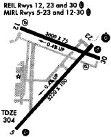
Runways
Runway Summary
| Runways: | 05/23 12/30 |
| Longest Runway: | 05/23 is 5819 ft (1774 m) long |
| Runways with an Instrument Approach: | 23 |
FDK Airport Runway Details
| Runway 05/23 | 5819 ft x 100 ft (1774 m x 30 m) | |
| Runway Length Source: | 3RD PARTY SURVEY as of 09/30/2020 | |
| Surface: | Asphalt - Good condition - Saw-cut or plastic grooved | |
| Runway Pavement Class: | 30 /F/C/X/T | |
| Runway Edge Lights: | High Intensity | |
Runway Weight Bearing Capacity (in thousands of pounds) |
||
| Single Wheel Landing Gear: | 60.0 | |
Runway 05 |
Runway 23 |
|
Elevation: |
308.9 | 282.6 |
Latitude: |
39-24-30.0613N | 39-25-13.7954N |
Longitude: |
077-22-54.5304W | 077-22-06.3842W |
|
Runway True Alignment: |
040 | 220 |
ILS Type: |
ILS | |
Glide Path Angle: |
3.0 degrees | 3.0 degrees |
Traffic Pattern: |
Right | Left |
Runway Markings Type: |
Nonprecision Instrument | Precision Instrument |
Runway Markings Condition: |
Good | Fair |
Object at End: |
TREES | TREES |
Object Height: |
51 | 85 |
Distance from End: |
1379 | 2925 |
Object Centerline Offset: |
293 ft. left of centerline | 595 ft. left of centerline |
Visual Glide Slope Indicators: |
4-Light PAPI On Left Side Of Runway | 4-Light PAPI On Left Side Of Runway |
Approach Light System: |
Omnidirectional Approach Lighting System | |
REIL: |
Yes | Yes |
Threshold Crossing Height: |
43 | 54 |
| Runway 12/30 | 3599 ft x 75 ft (1097 m x 23 m) | |
| Runway Length Source: | 3RD PARTY SURVEY as of 09/30/2020 | |
| Surface: | Asphalt - Good condition - No special surface treatment | |
| Runway Edge Lights: | Medium Intensity | |
Runway 12 |
Runway 30 |
|
Elevation: |
294.2 | 284.0 |
Latitude: |
39-25-24.1733N | 39-25-08.6035N |
Longitude: |
077-22-47.3514W | 077-22-06.1173W |
|
Runway True Alignment: |
116 | 296 |
Glide Path Angle: |
3.0 degrees | 4.0 degrees |
Traffic Pattern: |
Right | |
Runway Markings Type: |
Nonprecision Instrument | Nonprecision Instrument |
Runway Markings Condition: |
Fair | Fair |
Object at End: |
TREES | TREES |
Object Height: |
72 | |
Distance from End: |
1849 | |
Object Centerline Offset: |
293 ft. left of centerline | 595 ft. left of centerline |
Visual Glide Slope Indicators: |
2-Light PAPI On Left Side Of Runway | 2-Light PAPI On Left Side Of Runway |
REIL: |
Yes | Yes |
Threshold Crossing Height: |
40 | 37 |
Services
Airframe Repair: |
None |
Powerplant Repair: |
None |
Bottled Oxygen: |
None |
Bulk Oxygen: |
None |
Fuel Available: |
100LL |
Landing Fees: |
No |
Parking: |
Tiedowns available |
Maps & Diagrams
FDK Sectional
Flight Planning
at skyvector.com
at skyvector.com