Location
Latitude: |
30-24-00.1970N (30.400055) |
Longitude: |
086-28-17.3000W (-86.471472) |
Elevation: |
22.6 feet MSL (7 m MSL) |
Magnetic Variation: |
3.8 W (as of April 2024 from WMM2020 model) |
Time Zone: |
UTC -6.0 (Standard Time) UTC -5.0 (Daylight Savings Time) |
From City: |
01 N.M. E of Destin, Florida |
Found On: |
New Orleans Chart |
FAA Region: |
ASO |
Contacts
Manager: |
Publicly owned: |
| TRACY STAGE 1701 STATE ROAD 85 NORTH EGLIN AFB, FL 32542-1413 850-651-7160 |
OKALOOSA CO BOARD OF COMMISSIONERS, 101 EAST JAMES LEE BOULEVARD CRESTVIEW, FL 32536 850-689-5000 |
Operations
Airport Status: |
Operational |
Facility Use: |
Public |
Type: |
Airport |
Activation Date: |
02/1965 |
Control tower: |
Yes |
Attendance (Months/Days/Hours): |
Months/Days/Hours ALL/ALL/0600-2200 |
Boundary ARTCC: |
ZJX (Jacksonville) |
Responsible ARTCC: |
ZJX (Jacksonville) |
Lighting Schedule: |
SEE RMK |
Segmented Circle Indicator: |
Yes, Lighted |
Traffic Pattern Altitude (MSL): |
1023 feet (312 m) |
NOTAMs Facility: |
DTS |
NOTAM-D Service: |
Yes |
International Airport of Entry: |
No |
Customs Landing Rights: |
No |
Military Landing Rights: |
Yes |
Civil/Military Joint Use: |
No |
Based Aircraft
| Single Engine: | 54 |
| Multi Engine: | 15 |
| Jet Engine: | 21 |
| GA Helicopters: | 6 |
Annual Operations (as of 12/31/2018)
| Total Operations: | 63987 | |
| Air Taxi: | 654 | 1.0% |
| GA Local: | 11649 | 18.2% |
| GA Itinerant: | 51323 | 80.2% |
| Military Aircraft: | 361 | 0.6% |
Communications
| CTAF: | 118.450 |
| Unicom: | 123.075 |
| Tower: | DESTIN 118.45 Hrs: 0600-2200 |
| Clearance Del.: | 121.6 127.7 ;WHEN TWR CLSD 127.7 ;WHEN TWR CLSD 127.7 ;WHEN TWR CLSD 127.7 ;WHEN TWR CLSD |
| Ground: | 121.6 |
| Approach: | EGLIN |
| Departure: | EGLIN |
| ATIS: | 133.925 Hrs: 24 HRS |
| ASOS: | 133.925 (850-654-7128) |
Fixed Based Operators (FBOs) & Fuel
(Click on a business for detail)
Please help us keep this information up to date. This is a FREE SERVICE just like everything else on Airport Guide! If you see that a business needs to be added, modified, or deleted please fill out our Update Form.
To add, modify, or delete a business click here.
Please help us keep this information up to date. This is a FREE SERVICE just like everything else on Airport Guide! If you see that a business needs to be added, modified, or deleted please fill out our Update Form.
Area Code: 850 |
| Business Name | Frequency | Phone | Fuel Grade |
|---|---|---|---|
| Miracle Strip Aviation
Update FBO info |
Unicom 122.8 | 837-6135, -6136, -8277 | 100LL, Jet A |
Flight Service Stations
| Primary | Alternate | |
| FSS on Field: | N | |
| FSS Name (ID): | Gainesville(GNV) | |
| Frequency: | ||
| Toll Free Phone: | 1-800-WX-BRIEF |
Instrument Procedures / Charts
FAA Terminal Procedures valid from 0901Z 03/21/24 to 0901Z 04/18/24.
There are various types of charts available for an airport. They are listed in the Page Type column. Here is a legend for those types:
APD - Airport Diagram
DP - Departure Procedure Charts
HOT - Hot Spots
IAP - Instrument Approach Procedure Charts
MIN - Minimums
STAR - Standard Terminal Arrival Charts
| Page Type | Page Name | Volume | Action Since Last Cycle |
|---|---|---|---|
| APD | AIRPORT DIAGRAM | SE-3 | |
| IAP | RNAV (GPS) RWY 14 | SE-3 | |
| IAP | RNAV (GPS) RWY 32 | SE-3 | |
| MIN | ALTERNATE MINIMUMS | SE-3 | |
| MIN | TAKEOFF MINIMUMS | SE-3 |
Terminal Procedures are only available for airports in several countries with more being added all the time. If you are looking for a specific country's charts, please send an email to support(at)airportguide.com stating the country name. This will be used to prioritize the implementation.
Navigation Aids (Navaids) near DSI
| Dist (NM) | ID | Morse Code | Name | Type | Freq | True Hdg | Mag Hdg |
|---|---|---|---|---|---|---|---|
| 5.3 | DWG | _ . . . _ _ _ _ . | Warrington | TACAN | 134.50 | 331 | 335 |
| 11.4 | HRT | . . . . . _ . _ | Hurlburt | TACAN | 110.80 | 278 | 282 |
| 27.3 | NGS | _ . _ _ . . . . | Santa Rosa | TACAN | 133.60 | 298 | 302 |
| 27.4 | CE | _ . _ . . | Kobra | NDB | 201 | 352 | 356 |
| 27.7 | CEW | _ . _ . . . _ _ | Crestview | VORTAC | 115.90 | 337 | 341 |
| 34.3 | NSE | _ . . . . . | Whiting | TACAN | 112.30 | 304 | 308 |
| 35.9 | PFN | . _ _ . . . _ . _ . | Lynne | NDB | 278 | 96 | 100 |
| 36.6 | PKZ | . _ _ . _ . _ _ _ . . | Pickens | NDB | 326 | 273 | 277 |
| 43.8 | NPA | _ . . _ _ . . _ | Pensacola | TACAN | 117.20 | 266 | 270 |
| 44.9 | NUN | _ . . . _ _ . | Saufley | VOR | 112.25 | 275 | 279 |
| 50.5 | PAM | . _ _ . . _ _ _ | Tyndall | TACAN | 133.70 | 112 | 116 |
| 52.5 | BKK | _ . . . _ . _ _ . _ | Tri County | NDB | 275 | 58 | 62 |
| 54.5 | JUY | . _ _ _ . . _ _ . _ _ | Judd | NDB | 264 | 4 | 8 |
| 60.0 | OZ | _ _ _ _ _ . . | Brynt | NDB | 212 | 34 | 38 |
| 61.2 | EDN | . _ . . _ . | Enterprise | VOR | 116.60 | 28 | 32 |
| 61.7 | BVG | _ . . . . . . _ _ _ . | Boll Weevil | NDB | 352 | 23 | 27 |
| 64.7 | OZR | _ _ _ _ _ . . . _ . | Cairns | VOR-DME | 111.20 | 36 | 40 |
| 65.1 | ESU | . . . . . . _ | Summerdale | NDB | 204 | 275 | 278 |
| 68.8 | LOR | . _ . . _ _ _ . _ . | Lowe | NDB | 269 | 32 | 36 |
| 70.3 | SMY | . . . _ _ _ . _ _ | Soyya | NDB | 329 | 65 | 69 |
Nearby Airports with Fuel
Notices to Airmen (NOTAMS)
Remarks
| A110-2 | EXERCISE VIGILANCE DUE TO CLOSE PROXIMITY TO EGLIN AFB LCTD 6 NM NW. |
| A110-3 | ALL ACFT CTC EGLIN CD ON 127.7 FOR ATC DEP INSTR PRIOR TO TKOF WHEN TWR CLSD. |
| A110-4 | WHEN TWR CLSD; IFR ACFT RMN ON GND & CTC DEP CTL FOR CLIMB OUT INSTR & IFR RLS. |
| A110-5 | ARPT COND UNMON. |
| A110-6 | PARASAILING & BANNER TOWING WI 5 NM. |
| A110-7 | CAUTION: MEN & EQUIP ON & INVOF SAFETY AREA. |
| A16 | EXT 4 |
| A43-32 | RWY 32 PAPI UNUSABLE BEYOND 7 DEGREES LEFT AND RIGHT OF CNTRLN. |
| A81-APT | ACTVT HIRL RWY 14/32 - CTAF. |
Runways
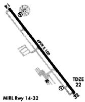
Runway Summary
| Runways: | 14/32 |
| Longest Runway: | 14/32 is 5001 ft (1524 m) long |
| Runways with an Instrument Approach: |
DSI Airport Runway Details
| Runway 14/32 | 5001 ft x 100 ft (1524 m x 30 m) | |
| Runway Length Source: | 3RD PARTY SURVEY as of 05/19/2019 | |
| Surface: | Asphalt - Good condition - No special surface treatment | |
| Runway Pavement Class: | 25 /F/B/W/T | |
| Runway Edge Lights: | High Intensity | |
Runway Weight Bearing Capacity (in thousands of pounds) |
||
| Single Wheel Landing Gear: | 38.0 | |
| Dual Wheel Landing Gear: | 67.0 | |
| Dual Tandem Wheel Landing Gear: | 113.0 | |
Runway 14 |
Runway 32 |
|
Elevation: |
22.2 | 21.0 |
Latitude: |
30-24-19.7356N | 30-23-40.6576N |
Longitude: |
086-28-34.8264W | 086-27-59.7758W |
|
Runway True Alignment: |
142 | 322 |
Glide Path Angle: |
3.0 degrees | 3.0 degrees |
Traffic Pattern: |
Left | Left |
Runway Markings Type: |
Nonprecision Instrument | Nonprecision Instrument |
Runway Markings Condition: |
Good | Good |
Object at End: |
TREES | BLDG |
Object Height: |
39 | 116 |
Object Marked/Lighted?: |
Lighted | |
Distance from End: |
1540 | 4855 |
Object Centerline Offset: |
45 ft. right of centerline | 325 ft. right of centerline |
Visual Glide Slope Indicators: |
4-Light PAPI On Left Side Of Runway | 4-Light PAPI On Left Side Of Runway |
Threshold Crossing Height: |
43 | 42 |
Services
Airframe Repair: |
Major |
Powerplant Repair: |
Major |
Bottled Oxygen: |
High Pressure / Low Pressure |
Fuel Available: |
100LL, Jet A+ |
Landing Fees: |
No |
Parking: |
Hangars and tiedowns available |
Maps & Diagrams
DSI Sectional
Flight Planning
at skyvector.com
at skyvector.com