Location
Latitude: |
37-45-47.2000N (37.763111) |
Longitude: |
099-57-55.5000W (-99.965417) |
Elevation: |
2595.5 feet MSL (791 m MSL) |
Magnetic Variation: |
4.7 E (as of April 2024 from WMM2020 model) |
Time Zone: |
UTC -6.0 (Standard Time) UTC -5.0 (Daylight Savings Time) |
From City: |
03 N.M. E of Dodge City, Kansas |
Found On: |
Wichita Chart |
FAA Region: |
ACE |
Contacts
Manager: |
Publicly owned: |
| MS KELLI ENLOW 100 AIRPORT RD DODGE CITY, KS 67801 620-225-8100 |
CITY OF DODGE CITY PO BOX 880 DODGE CITY, KS 67801 620-225-8100 |
Operations
Airport Status: |
Operational |
Facility Use: |
Public |
Type: |
Airport |
Activation Date: |
04/1940 |
Control tower: |
No |
Attendance (Months/Days/Hours): |
Months/Days/Hours ALL/ALL/0600-2200 |
Boundary ARTCC: |
ZKC (Kansas City) |
Responsible ARTCC: |
ZKC (Kansas City) |
Lighting Schedule: |
SEE RMK |
Segmented Circle Indicator: |
Yes |
Traffic Pattern Altitude (MSL): |
3596 feet (1096 m) |
NOTAMs Facility: |
DDC |
NOTAM-D Service: |
Yes |
International Airport of Entry: |
No |
Customs Landing Rights: |
No |
Military Landing Rights: |
Yes |
Civil/Military Joint Use: |
No |
Aircraft Rescue and Firefighting: |
Class I ARFF Index: A Air Carrier Service: Scheduled Certification Date: 06/1976 |
Based Aircraft
| Single Engine: | 23 |
| Multi Engine: | 14 |
| GA Helicopters: | 1 |
Annual Operations (as of 12/31/2022)
| Total Operations: | 24200 | |
| Commercial: | 4500 | 18.6% |
| Air Taxi: | 1500 | 6.2% |
| GA Local: | 12000 | 49.6% |
| GA Itinerant: | 6000 | 24.8% |
| Military Aircraft: | 200 | 0.8% |
Communications
| CTAF: | 122.700 |
| Unicom: | 122.700 |
| ASOS: | 118.525 (620-227-9721) |
- APCH/DEP CTL SVC PRVDD BY KANSAS CITY ARTCC (ZKC) ON FREQS 125.2/285.425 (GARDEN CITY RCAG).
Fixed Based Operators (FBOs) & Fuel
(Click on a business for detail)
Please help us keep this information up to date. This is a FREE SERVICE just like everything else on Airport Guide! If you see that a business needs to be added, modified, or deleted please fill out our Update Form.
To add, modify, or delete a business click here.
Please help us keep this information up to date. This is a FREE SERVICE just like everything else on Airport Guide! If you see that a business needs to be added, modified, or deleted please fill out our Update Form.
Area Code: 620 |
| Business Name | Frequency | Phone | Fuel Grade |
|---|---|---|---|
| Crotts Aircraft Service, Inc.
Update FBO info |
Unicom 122.7 | 227-3553 | 100LL, Jet A |
Flight Service Stations
| Primary | Alternate | |
| FSS on Field: | N | |
| FSS Name (ID): | Wichita(ICT) | |
| Frequency: | ||
| Toll Free Phone: | 1-800-WX-BRIEF |
Instrument Procedures / Charts
FAA Terminal Procedures valid from 0901Z 03/21/24 to 0901Z 04/18/24.
There are various types of charts available for an airport. They are listed in the Page Type column. Here is a legend for those types:
APD - Airport Diagram
DP - Departure Procedure Charts
HOT - Hot Spots
IAP - Instrument Approach Procedure Charts
MIN - Minimums
STAR - Standard Terminal Arrival Charts
| Page Type | Page Name | Volume | Action Since Last Cycle |
|---|---|---|---|
| APD | AIRPORT DIAGRAM | NC-2 | |
| HOT | HOT SPOT | NC-2 | |
| IAP | ILS OR LOC RWY 14 | NC-2 | |
| IAP | RNAV (GPS) RWY 02 | NC-2 | |
| IAP | RNAV (GPS) RWY 14 | NC-2 | |
| IAP | RNAV (GPS) RWY 20 | NC-2 | |
| IAP | RNAV (GPS) RWY 32 | NC-2 | |
| IAP | VOR RWY 14 | NC-2 | |
| IAP | VOR RWY 32 | NC-2 | |
| MIN | ALTERNATE MINIMUMS | NC-2 |
Terminal Procedures are only available for airports in several countries with more being added all the time. If you are looking for a specific country's charts, please send an email to support(at)airportguide.com stating the country name. This will be used to prioritize the implementation.
Navigation Aids (Navaids) near DDC
| Dist (NM) | ID | Morse Code | Name | Type | Freq | True Hdg | Mag Hdg |
|---|---|---|---|---|---|---|---|
| 5.6 | DDC | _ . . _ . . _ . _ . | Dodge City | VORTAC | 108.20 | 340 | 335 |
| 36.2 | GC | _ _ . _ . _ . | Pieve | NDB | 347 | 276 | 271 |
| 37.2 | GCK | _ _ . _ . _ . _ . _ | Garden City | VORTAC | 113.30 | 284 | 279 |
| 49.2 | LQR | . _ . . _ _ . _ . _ . | Larned | NDB | 296 | 57 | 53 |
| 56.4 | BFK | _ . . . . . _ . _ . _ | Buffalo | NDB | 215 | 162 | 157 |
| 57.8 | PTT | . _ _ . _ _ | Pratt | NDB | 356 | 91 | 87 |
| 60.1 | GB | _ _ . _ . . . | Babsy | NDB | 419 | 60 | 56 |
| 61.2 | TQK | _ _ _ . _ _ . _ | Scott City | NDB | 256 | 314 | 309 |
| 61.6 | HIL | . . . . . . . _ . . | Hilyn | NDB | 338 | 54 | 50 |
| 64.5 | LBL | . _ . . _ . . . . _ . . | Liberal | TACAN | 112.30 | 228 | 223 |
| 67.3 | LB | . _ . . _ . . . | Panck | NDB | 383 | 224 | 219 |
| 67.3 | ULS | . . _ . _ . . . . . | Ulysses | NDB | 395 | 261 | 256 |
| 69.1 | HY | . . . . _ . _ _ | Nette | NDB | 374 | 28 | 24 |
| 72.7 | HYS | . . . . _ . _ _ . . . | Hays | VORTAC | 110.40 | 26 | 22 |
| 76.1 | HQG | . . . . _ _ . _ _ _ . | Hugoton | NDB | 365 | 242 | 237 |
| 84.3 | JHN | . _ _ _ . . . . _ . | Bear Creek | NDB | 341 | 265 | 260 |
| 85.1 | MDF | _ _ _ . . . . _ . | Mooreland | NDB | 284 | 154 | 150 |
| 85.3 | MMB | _ _ _ _ _ . . . | Mitbee | VORTAC | 115.60 | 177 | 172 |
| 89.3 | PYX | . _ _ . _ . _ _ _ . . _ | Perryton | NDB | 266 | 205 | 200 |
| 89.3 | LYO | . _ . . _ . _ _ _ _ _ | Lyons | NDB | 386 | 66 | 62 |
Nearby Airports with Fuel
Notices to Airmen (NOTAMS)
Remarks
| A110-1 | DUE TO RY CROWNING, APCH ENDS OF RY 02 AND RY 20 ARE NOT VISIBLE FROM THE OPPOSITE END OF THE RUNWAY. |
| A110-3 | FOR CD IF UNA TO CTC ON FSS FREQ, CTC KANSAS CITY ARTCC AT 913-254-8508. |
| A26 | ARFF INDEX B EQUIPMENT IS PROVIDED. 24 HRS PPR FOR UNSKED ACR OPNS WITH MORE THAN 30 PASSENGER SEATS; CALL FORD COUNTY COMMUNICATIONS AT 620-227-4646. |
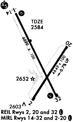
| A81-APT | DUSK-DAWN. ACTVT MALSR RWY 14; REIL RWY 02/20, RWY 32; PAPI RWY 02 & 20, VASI RWY 14 & 32; MIRL RWY 14/32 & 02/20 - CTAF |
Runways
Runway Summary
| Runways: | 02/20 14/32 |
| Longest Runway: | 14/32 is 6899 ft (2103 m) long |
| Runways with an Instrument Approach: | 14 |
DDC Airport Runway Details
| Runway 02/20 | 4649 ft x 100 ft (1417 m x 30 m) | |
| Runway Length Source: | 3RD PARTY SURVEY as of 06/28/2010 | |
| Surface: | Asphalt - Fair condition - No special surface treatment | |
| Runway Pavement Class: | 9 /F/D/X/T | |
| Runway Edge Lights: | Medium Intensity | |
Runway Weight Bearing Capacity (in thousands of pounds) |
||
| Single Wheel Landing Gear: | 24.0 | |
Runway 02 |
Runway 20 |
|
Elevation: |
2595.0 | 2563.8 |
Latitude: |
37-45-19.6103N | 37-45-58.4304N |
Longitude: |
099-58-03.8986W | 099-57-32.9262W |
|
Runway True Alignment: |
032 | 212 |
Glide Path Angle: |
3.0 degrees | 3.0 degrees |
Traffic Pattern: |
Left | Left |
Runway Markings Type: |
Nonprecision Instrument | Nonprecision Instrument |
Runway Markings Condition: |
Fair | Fair |
Visual Glide Slope Indicators: |
4-Light PAPI On Left Side Of Runway | 4-Light PAPI On Left Side Of Runway |
REIL: |
Yes | Yes |
Threshold Crossing Height: |
37 | 45 |
Declared Distances |
||
Take Off Run Avbl. (TORA): |
4649 | 4649 |
Take Off Distance Avbl. (TODA): |
4649 | 4649 |
Actual Stop Dist. Avbl. (ASDA): |
4649 | 4649 |
Landing Dist. Avbl. (LDA): |
4649 | 4649 |
| Runway 14/32 | 6899 ft x 100 ft (2103 m x 30 m) | |
| Runway Length Source: | 3RD PARTY SURVEY as of 06/28/2010 | |
| Surface: | Asphalt - Fair condition - No special surface treatment | |
| Runway Pavement Class: | 32 /F/D/X/T | |
| Runway Edge Lights: | Medium Intensity | |
Runway Weight Bearing Capacity (in thousands of pounds) |
||
| Single Wheel Landing Gear: | 81.0 | |
| Dual Wheel Landing Gear: | 103.0 | |
| Dual Tandem Wheel Landing Gear: | 168.0 | |
Runway 14 |
Runway 32 |
|
Elevation: |
2582.8 | 2586.5 |
Latitude: |
37-46-23.3719N | 37-45-22.1685N |
Longitude: |
099-58-19.2681W | 099-57-41.3770W |
|
Runway True Alignment: |
154 | 334 |
ILS Type: |
ILS | |
Glide Path Angle: |
3.0 degrees | 3.0 degrees |
Traffic Pattern: |
Left | Left |
Runway Markings Type: |
Precision Instrument | Precision Instrument |
Runway Markings Condition: |
Good | Good |
Visual Glide Slope Indicators: |
4-Box VASI On Left Side Of Runway | 4-Box VASI On Left Side Of Runway |
Approach Light System: |
1,400 Foot Medium Intensity Approach Lighting System With Runway Alignment Indicator Lights | |
REIL: |
Yes | |
Threshold Crossing Height: |
55 | 40 |
Threshold Elevation: |
2589.6 | |
Displaced Threshold: |
569 | |
Threshold Latitude: |
37-45-27.2129N | |
Threshold Longitude: |
099-57-44.5115W | |
Declared Distances |
||
Take Off Run Avbl. (TORA): |
6899 | 6899 |
Take Off Distance Avbl. (TODA): |
6899 | 6899 |
Actual Stop Dist. Avbl. (ASDA): |
6329 | 6899 |
Landing Dist. Avbl. (LDA): |
6329 | 6329 |
Services
Airframe Repair: |
Major |
Powerplant Repair: |
Major |
Bottled Oxygen: |
None |
Bulk Oxygen: |
None |
Fuel Available: |
100LL, Jet A |
Landing Fees: |
No |
Parking: |
Hangars and tiedowns available |
Other Services: |
Parachute rental |
Maps & Diagrams
DDC Sectional
Flight Planning
at skyvector.com
at skyvector.com