
Location
Latitude: |
49-000-46.0728N (49.012798) |
Longitude: |
002-33-000E (2.55) |
Elevation: |
392 feet MSL (119 m MSL) |
Magnetic Variation: |
1.8 E (as of April 2024 from WMM2020 model) |
Time Zone: |
UTC +1.0 (Standard Time) UTC +2.0 (Daylight Savings Time) |
Contacts
Manager: |
: |
Operations
Airport Status: |
Operational |
Facility Use: |
Public |
Type: |
Airport |
Traffic Pattern Altitude (MSL): |
1392 feet (424 m) |
Based Aircraft
Annual Operations (as of )
Communications
| DE GAULLE TWR: | 119.25 |
| DE GAULLE TWR: | 120.65 |
| DE GAULLE GND: | 121.6 |
| DE GAULLE APP: | 121.15 |
| DE GAULLE APP: | 136.275 |
| DE GAULLE DEP: | 124.35 |
| DE GAULLE ATIS: | 127.125 |
| DE GAULLE TRAFFIC: | 118.1 |
| DE GAULLE PREFLIGHT: | 126.65 |
Fixed Based Operators (FBOs) & Fuel
(Click on a business for detail)
Please help us keep this information up to date. This is a FREE SERVICE just like everything else on Airport Guide! If you see that a business needs to be added, modified, or deleted please fill out our Update Form.
To add, modify, or delete a business click here.
Please help us keep this information up to date. This is a FREE SERVICE just like everything else on Airport Guide! If you see that a business needs to be added, modified, or deleted please fill out our Update Form.
| Business Name | Frequency | Phone | Fuel Grade |
|---|
Flight Service Stations
| Primary | Alternate | |
| FSS on Field: | ||
| FSS Name (ID): | ||
| Frequency: | ||
| Toll Free Phone: |
Instrument Procedures / Charts
Terminal Procedures are only available for airports in several countries with more being added all the time. If you are looking for a specific country's charts, please send an email to support(at)airportguide.com stating the country name. This will be used to prioritize the implementation.
Navigation Aids (Navaids) near CDG
| Dist (NM) | ID | Morse Code | Name | Type | Freq | True Hdg | Mag Hdg |
|---|---|---|---|---|---|---|---|
| 2.0 | CGN | Charles de Gaulle | VOR-DME | 115.35 | 282 | 280 | |
| 3.0 | PGS | Charles de Gaulle | VOR-DME | 117.05 | 105 | 103 | |
| 4.4 | BT | Le Bourget | VOR-DME | 116.10 | 238 | 236 | |
| 14.6 | CRL | Creil | VORTAC | 109.20 | 354 | 352 | |
| 15.6 | TH | Villacoublay | NDB | 302 | 205 | 203 | |
| 18.2 | OL | Orly | VOR-DME | 111.20 | 200 | 198 | |
| 20.8 | PON | Pontoise | VOR | 111.60 | 284 | 282 | |
| 20.9 | CLM | Coulommiers | VOR-DME | 112.90 | 118 | 116 | |
| 22.5 | BSN | Boursonne | VOR-DME | 114.85 | 61 | 59 | |
| 23.0 | TA | Villacoublay | NDB | 287 | 231 | 229 | |
| 23.5 | TSU | Toussus | VOR | 108.25 | 228 | 226 | |
| 27.0 | CPE | Compiègne | VOR-DME | 109.65 | 21 | 19 | |
| 29.8 | BVS | Beauvais | VOR | 115.90 | 328 | 326 | |
| 30.7 | RBT | Rambouillet | VOR-DME | 114.70 | 225 | 223 | |
| 32.5 | MTD | Montdidier | VOR | 113.65 | 355 | 353 | |
| 33.4 | HOL | Villacoublay | NDB | 315 | 239 | 237 | |
| 35.0 | MLN | Melun | VOR-DME | 113.60 | 162 | 160 | |
| 41.1 | CTL | Châtillon-sur-Marne | VOR-DME | 117.60 | 79 | 77 | |
| 42.3 | EPR | Epernon | VOR-DME | 115.65 | 236 | 234 | |
| 46.8 | BRY | Bray-sur-Seine | VOR-DME | 114.10 | 140 | 138 |
Nearby Airports with Fuel
| Dist (NM) | Name (Airport IDs) | True Hdg | Mag Hdg | Fuel Grade |
|---|
Notices to Airmen (NOTAMS)
Remarks
No remarks for this landing facility
Runways
Runway Summary
| Runways: | 08L/26R 08R/26L 09L/27R 09R/27L |
| Longest Runway: | 08L/26R is 13829 ft (4215 m) long |
| Runways with an Instrument Approach: |
CDG Airport Runway Details
| Runway 08L/26R | 13829 ft x 148 ft (4215 m x 45 m) | |
| Runway Edge Lights: | Yes Intensity | |
Runway 08L |
Runway 26R |
|
Elevation: |
338 | 318 |
Latitude: |
48.99570083618 | 48.99879837036 |
Longitude: |
2.5527400970458 | 2.6101799011230 |
|
Runway True Alignment: |
85 | 265 |
Glide Path Angle: |
0.0 degrees | 0.0 degrees |
REIL: |
Yes | Yes |
Threshold Elevation: |
338 | 318 |
Displaced Threshold: |
1969 |
| Runway 08R/26L | 8858 ft x 197 ft (2700 m x 60 m) | |
| Runway Edge Lights: | Yes Intensity | |
Runway 08R |
Runway 26L |
|
Elevation: |
336 | 316 |
Latitude: |
48.99290084838 | 48.99489974975 |
Longitude: |
2.5656599998474 | 2.6024301052093 |
|
Runway True Alignment: |
85.1 | 265.1 |
Glide Path Angle: |
0.0 degrees | 0.0 degrees |
REIL: |
Yes | Yes |
Threshold Elevation: |
336 | 316 |
| Runway 09L/27R | 8858 ft x 197 ft (2700 m x 60 m) | |
| Runway Edge Lights: | Yes Intensity | |
Runway 09L |
Runway 27R |
|
Elevation: |
378 | 392 |
Latitude: |
49.02470016479 | 49.02669906616 |
Longitude: |
2.5248899459838 | 2.5616900920867 |
|
Runway True Alignment: |
85.3 | 265.3 |
Glide Path Angle: |
0.0 degrees | 0.0 degrees |
REIL: |
Yes | Yes |
Threshold Elevation: |
378 | 392 |
| Runway 09R/27L | 13780 ft x 148 ft (4200 m x 45 m) | |
| Runway Edge Lights: | Yes Intensity | |
Runway 09R |
Runway 27L |
|
Elevation: |
370 | 387 |
Latitude: |
49.02059936523 | 49.02370071411 |
Longitude: |
2.5130600929260 | 2.5702900886535 |
|
Runway True Alignment: |
86 | 266 |
Glide Path Angle: |
0.0 degrees | 0.0 degrees |
REIL: |
Yes | Yes |
Threshold Elevation: |
370 | 387 |
Displaced Threshold: |
1969 |
Services
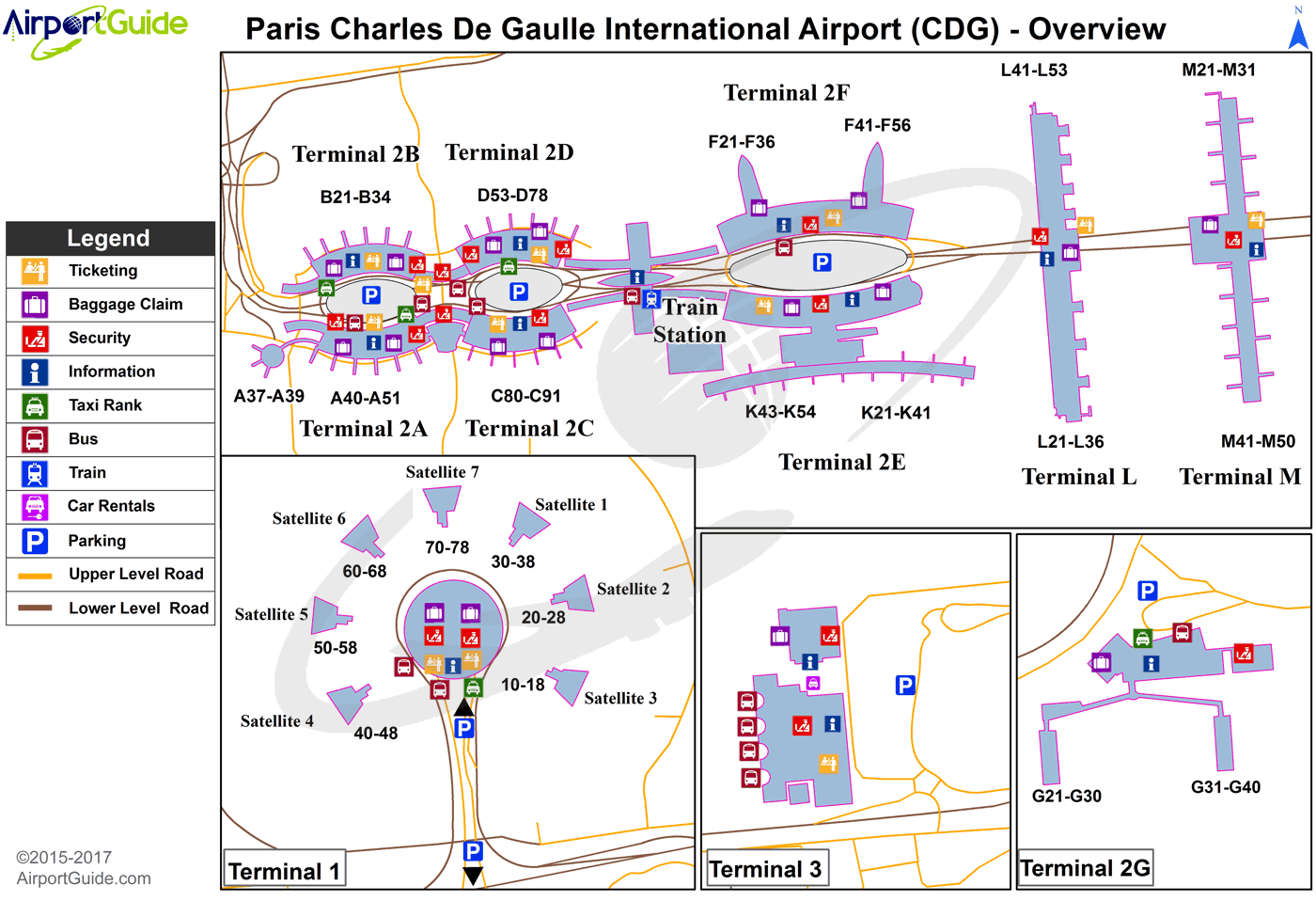
Maps & Diagrams
CDG Sectional
Flight Planning
at skyvector.com
at skyvector.com
