
Location
Latitude: |
44-49-41.8817N (44.8283) |
Longitude: |
0000-42-56.0017W (-.715556) |
Elevation: |
162 feet MSL (49 m MSL) |
Magnetic Variation: |
1.1 E (as of April 2024 from WMM2020 model) |
Time Zone: |
UTC +1.0 (Standard Time) UTC +2.0 (Daylight Savings Time) |
Contacts
Manager: |
: |
Operations
Airport Status: |
Operational |
Facility Use: |
Public |
Type: |
Airport |
Traffic Pattern Altitude (MSL): |
1162 feet (354 m) |
Based Aircraft
Annual Operations (as of )
Communications
| AQUITAINE INFO: | 120.575 |
| TWR: | 118.3 |
| GND: | 121.9 |
| AQUITAINE APP: | 118.6 |
| APP: | 121.2 |
| ATIS: | 131.15 |
| OPNS: | 143.175 |
Fixed Based Operators (FBOs) & Fuel
(Click on a business for detail)
Please help us keep this information up to date. This is a FREE SERVICE just like everything else on Airport Guide! If you see that a business needs to be added, modified, or deleted please fill out our Update Form.
To add, modify, or delete a business click here.
Please help us keep this information up to date. This is a FREE SERVICE just like everything else on Airport Guide! If you see that a business needs to be added, modified, or deleted please fill out our Update Form.
| Business Name | Frequency | Phone | Fuel Grade |
|---|---|---|---|
| Aviapartner
Website Update FBO info |
131.400 | TEL +33 5 56 34 59 48 GSM (24/7) +33 6 12 54 57 49 |
Flight Service Stations
| Primary | Alternate | |
| FSS on Field: | ||
| FSS Name (ID): | ||
| Frequency: | ||
| Toll Free Phone: |
Instrument Procedures / Charts
Terminal Procedures are only available for airports in several countries with more being added all the time. If you are looking for a specific country's charts, please send an email to support(at)airportguide.com stating the country name. This will be used to prioritize the implementation.
Navigation Aids (Navaids) near BOD
| Dist (NM) | ID | Morse Code | Name | Type | Freq | True Hdg | Mag Hdg |
|---|---|---|---|---|---|---|---|
| 0.3 | BMC | Bordeaux | VOR-DME | 113.75 | 250 | 249 | |
| 0.3 | BDX | Bordeaux | TACAN | 114.40 | 258 | 257 | |
| 9.1 | BD | Bordeaux | NDB | 393 | 45 | 44 | |
| 13.8 | BE | Bordeaux | NDB | 318 | 79 | 78 | |
| 20.4 | NB | Bordeaux | NDB | 361 | 20 | 19 | |
| 24.0 | CAA | Cazaux | NDB | 382 | 226 | 225 | |
| 25.3 | CAA | Cazaux | TACAN | 110.80 | 225 | 224 | |
| 25.6 | SAU | Sauveterre | VOR | 116.80 | 110 | 109 | |
| 52.7 | CNA | Cognac | VOR-DME | 114.65 | 18 | 17 | |
| 52.9 | CGC | Cognac | TACAN | 116.20 | 18 | 17 | |
| 53.3 | CGC | Cognac | NDB | 354 | 18 | 17 | |
| 55.8 | MDM | Mont De Marsan | TACAN | 108.70 | 170 | 169 | |
| 56.8 | BGC | Bergerac | NDB | 374 | 90 | 89 | |
| 86.7 | BZ | Biarritz | NDB | 341 | 200 | 199 | |
| 87.0 | TAN | Lahitte | VOR | 111.80 | 159 | 158 | |
| 88.5 | AGN | Agen | VOR-DME | 114.80 | 129 | 128 | |
| 88.6 | BTZ | Biarritz | VOR-DME | 114.15 | 203 | 202 | |
| 90.7 | CSM | Castelsarrasin Moissac | NDB | 327 | 118 | 117 | |
| 94.4 | LMG | Limoges | VOR-DME | 114.50 | 50 | 49 | |
| 97.1 | TBO | Tarbes | VOR | 113.90 | 157 | 156 |
Nearby Airports with Fuel
| Dist (NM) | Name (Airport IDs) | True Hdg | Mag Hdg | Fuel Grade |
|---|
Notices to Airmen (NOTAMS)
Remarks
No remarks for this landing facility
Runways
Runway Summary
| Runways: | 05/23 11/29 |
| Longest Runway: | 05/23 is 10171 ft (3100 m) long |
| Runways with an Instrument Approach: |
BOD Airport Runway Details
| Runway 05/23 | 10171 ft x 148 ft (3100 m x 45 m) | |
| Runway Edge Lights: | Yes Intensity | |
Runway 05 |
Runway 23 |
|
Elevation: |
160 | 151 |
Latitude: |
44.81909942626 | 44.83869934082 |
Longitude: |
-0.728982985019 | -0.700999975204 |
|
Runway True Alignment: |
46 | 226 |
Glide Path Angle: |
0.0 degrees | 0.0 degrees |
REIL: |
Yes | Yes |
Threshold Elevation: |
160 | 151 |
| Runway 11/29 | 7923 ft x 148 ft (2415 m x 45 m) | |
| Runway Edge Lights: | Yes Intensity | |
Runway 11 |
Runway 29 |
|
Elevation: |
153 | 160 |
Latitude: |
44.83160018920 | 44.82540130615 |
Longitude: |
-0.729242026805 | -0.699896991252 |
|
Runway True Alignment: |
107 | 287 |
Glide Path Angle: |
0.0 degrees | 0.0 degrees |
REIL: |
Yes | Yes |
Threshold Elevation: |
153 | 160 |
Services
Other Services: |
Ground Handling - Passenger Services, Ramp Services, Traffic Operations Cargo Services The FBO services we provide are: • Domestic & international handling • Fast turnarounds • Passenger & crew assistance • Airport & airway slot coordination • Flight planning & weather - NOTAMs • Traffic rights & landing permits • Aircraft charter reservation • Catering arrangements • Hotel & restaurant reservations • Limousine & car rental • Customs & immigration assistance • Change aircraft charter reservation (by aircraft & helicopter charter) • Fueling and fueling arrangements |
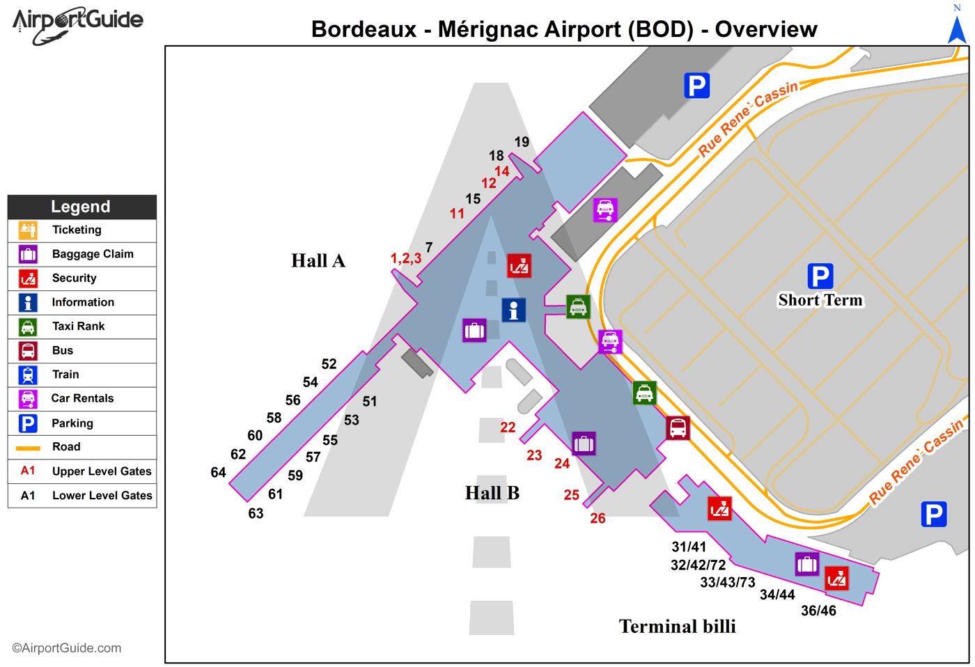
Maps & Diagrams
BOD Sectional
Flight Planning
at skyvector.com
at skyvector.com
