Location
Latitude: |
36-07-28.1100N (36.124475) |
Longitude: |
086-40-41.4500W (-86.678181) |
Elevation: |
599.0 feet MSL (183 m MSL) |
Magnetic Variation: |
4.2 W (as of April 2024 from WMM2020 model) |
Time Zone: |
UTC -6.0 (Standard Time) UTC -5.0 (Daylight Savings Time) |
From City: |
05 N.M. SE of Nashville, Tennessee |
Found On: |
Atlanta Chart |
FAA Region: |
ASO |
Contacts
Manager: |
Publicly owned: |
| ADAM FLOYD 140 BNA PARK DR. SUITE 520 NASHVILLE, TN 37214 615-275-1825 |
METRO NASHVILLE ARPT AUTH 140 BNA PARK DR. SUITE 520 NASHVILLE, TN 37214 615-275-1600 |
Operations
Airport Status: |
Operational |
Facility Use: |
Public |
Type: |
Airport |
Activation Date: |
12/1937 |
Control tower: |
Yes |
Attendance (Months/Days/Hours): |
Months/Days/Hours ALL/ALL/ALL |
Boundary ARTCC: |
ZME (Memphis) |
Responsible ARTCC: |
ZME (Memphis) |
Lighting Schedule: |
SS-SR |
Segmented Circle Indicator: |
No |
Traffic Pattern Altitude (MSL): |
1599 feet (487 m) |
NOTAMs Facility: |
BNA |
NOTAM-D Service: |
Yes |
International Airport of Entry: |
No |
Customs Landing Rights: |
Yes |
Military Landing Rights: |
Yes |
Civil/Military Joint Use: |
No |
Aircraft Rescue and Firefighting: |
Class I ARFF Index: D Air Carrier Service: Scheduled Certification Date: 05/1973 |
Based Aircraft
| Single Engine: | 18 |
| Multi Engine: | 11 |
| Jet Engine: | 73 |
| GA Helicopters: | 1 |
| Military Aircraft: | 15 |
Annual Operations (as of 04/30/2023)
| Total Operations: | 280564 | |
| Commercial: | 206456 | 73.6% |
| Air Taxi: | 32704 | 11.7% |
| GA Itinerant: | 38719 | 13.8% |
| Military Aircraft: | 2685 | 1.0% |
Communications
| Unicom: | 122.950 |
| Tower: | NASHVILLE 118.6 257.8 Hrs: 24 |
| Ground: | 121.9 348.6 |
| Approach: | NASHVILLE 118.4 ;EAST 360.7 ;EAST 372.0 ;WEST Hrs: 24 |
| Departure: | NASHVILLE 118.4 ;EAST 360.7 ;EAST 372.0 ;WEST Hrs: 24 |
| ATIS: | 135.1 Hrs: 24 |
| ASOS: | (615-360-6133) |
| CLASS C: | 372.0 ;WEST |
| CLASS C: | 118.4 ;EAST |
| EMERG: | 243.0 |
| ALCP: | 314.4 |
| CLASS C: | 119.35 ;WEST |
| EMERG: | 121.5 |
| CLASS C: | 360.7 ;EAST |
Fixed Based Operators (FBOs) & Fuel
(Click on a business for detail)
Please help us keep this information up to date. This is a FREE SERVICE just like everything else on Airport Guide! If you see that a business needs to be added, modified, or deleted please fill out our Update Form.
To add, modify, or delete a business click here.
Please help us keep this information up to date. This is a FREE SERVICE just like everything else on Airport Guide! If you see that a business needs to be added, modified, or deleted please fill out our Update Form.
Area Code: 615 |
| Business Name | Frequency | Phone | Fuel Grade |
|---|---|---|---|
| Signature Flight Support
Website Update FBO info |
Unicom: 122.95, Arinc: 131.1 | +1 615 361 3000 | 100LL, Jet A |
| Stevens Aviation, Inc.
Update FBO info |
360-8100 | 100LL, Jet A |
Flight Service Stations
| Primary | Alternate | |
| FSS on Field: | N | |
| FSS Name (ID): | Nashville(BNA) | |
| Frequency: | ||
| Toll Free Phone: | 1-800-WX-BRIEF |
Instrument Procedures / Charts
FAA Terminal Procedures valid from 0901Z 03/21/24 to 0901Z 04/18/24.
There are various types of charts available for an airport. They are listed in the Page Type column. Here is a legend for those types:
APD - Airport Diagram
DP - Departure Procedure Charts
HOT - Hot Spots
IAP - Instrument Approach Procedure Charts
MIN - Minimums
STAR - Standard Terminal Arrival Charts
Terminal Procedures are only available for airports in several countries with more being added all the time. If you are looking for a specific country's charts, please send an email to support(at)airportguide.com stating the country name. This will be used to prioritize the implementation.
Navigation Aids (Navaids) near BNA
| Dist (NM) | ID | Morse Code | Name | Type | Freq | True Hdg | Mag Hdg |
|---|---|---|---|---|---|---|---|
| 0.8 | BNA | _ . . . _ . . _ | Nashville | VORTAC | 114.10 | 336 | 340 |
| 1.0 | BNA | _ . . . _ . . _ | Nashville Metropoln | VOT | 108.60 | 122 | 126 |
| 4.9 | VI | . . . _ . . | Opery | NDB | 344 | 14 | 18 |
| 10.8 | MQY | _ _ _ _ . _ _ . _ _ | Smyrna | VOT | 110.20 | 130 | 134 |
| 14.5 | SWZ | . . . . _ _ _ _ . . | Sewart | NDB | 391 | 133 | 137 |
| 17.8 | FQW | . . _ . _ _ . _ . _ _ | Walter Hill | NDB | 371 | 123 | 127 |
| 18.1 | JUE | . _ _ _ . . _ . | Lebanon | NDB | 414 | 76 | 80 |
| 25.0 | ON | _ _ _ _ . | Music | NDB | 279 | 323 | 327 |
| 35.7 | SYI | . . . _ . _ _ . . | Shelbyville | VOR-DME | 113.55 | 160 | 164 |
| 36.6 | DMZ | _ . . _ _ _ _ . . | Dickson | NDB | 203 | 270 | 274 |
| 36.9 | PBC | . _ _ . _ . . . _ . _ . | Maury County | NDB | 365 | 213 | 217 |
| 38.0 | LUG | . _ . . . . _ _ _ . | Verona | NDB | 251 | 189 | 193 |
| 39.8 | SYI | . . . _ . _ _ . . | Bomar | FAN MARKER | 164 | 168 | |
| 41.4 | GHM | _ _ . . . . . _ _ | Graham | DME | 111.6 | 245 | 249 |
| 41.9 | CK | _ . _ . _ . _ | Snuff | NDB | 335 | 305 | 309 |
| 43.0 | SKN | . . . _ . _ _ . | Hurricane | NDB | 256 | 101 | 106 |
| 45.1 | ULH | . . _ . _ . . . . . . | Burwi | NDB | 332 | 151 | 155 |
| 46.3 | BW | _ . . . . _ _ | Noora | NDB | 236 | 11 | 15 |
| 46.4 | CKV | _ . _ . _ . _ . . . _ | Clarksville | VOR-DME | 110.60 | 310 | 314 |
| 49.4 | UXM | . . _ _ . . _ _ _ | Tullahoma Regional | VOR | 109.65 | 154 | 158 |
Nearby Airports with Fuel
Notices to Airmen (NOTAMS)
Remarks
| A110-14 | 180 DEG TURNS OVR 12500 LBS NA ON ASPH SFC. |
| A110-15 | FLT OVR MAIN TRML NA. |
| A110-17 | BIRD ACT ON & INVOF ARPT. |
| A110-18 | DO NOT CONFUSE TWY S FOR RWY 20C. |
| A110-3 | CTN: READ BACK & COMPLIANCE OF RWY HLDG INSTRN RQR; SPCLY TWY K & RWY 20C, TWY L AT RWY 13 & TWY H AT RWY 31. |
| A110-31 | ANG: PPR - MUSIC CITY OPS 615-367-5579. |
| A110-36 | MIL & ACFT MORE THAN 12500 LB PRAC APCH NA; PRAC APCH BTN 2300-0700 NA. |
| A110-37 | TRML APRON TAX BTN ACR PUSHBACK OPS & GATES NA. |
| A110-38 | ADHERE TO TWY & TXL CNTRLN WI TRML APRON. |
| A110-39 | TRML RAMP, N TRML RAMP & NON-MOVMT AREA UNCTLD; BFR USE - 122.95. |
| A110-4 | FLT NOTIFICATION SVC (ADCUS) AVBL. |
| A110-42 | PAVEMENT ON W SIDE OF RWY 2R/20L BTN TXY H3 & H4 MKD AS A VEHICLE ACES ROAD ONLY. |
| A110-44 | TRML RAMP OPS TRML D GATE D1-D6 & TRML C GATE C1-C11 & GATE C16-C27 PPR BFR RAMP ENTRY OR PUSHBACK 0500-2300 - 129.95. |
| A110-45 | TRML APRON TXL Z, Y1, Y2 & TXL Y BTN TXL Y3 & Y4 CLSD TO WINGSPAN MORE THAN 118 FT. |
| A110-46 | TRML RAMP OPS TRML B GATE B6, B8, B10, TRML C GATE C13-C15 & TRML T GATE T1-T6 PPR BFR RAMP ENTRY OR PUSHBACK 0500-2300 - 131.375. |
| A110-47 | RWY 2L-20R, 2C-20C, 2R-20L, 13-31 CTL MRKGS AND LEAD OFF/ON MRKGS IN TDZ OBSC DUE TO RUBBER BUILD-UP |
| A110-6 | TBJT RWY NOISE ABATEMENT PROC; MIL TBJT USE RWY 13/31 FOR ARR & DEP. |
| A30A-13 | LGTD JET BLAST FENCE 568 FT MSL 1167 FT NW THR. |
| A30A-31 | LGTD JET BLAST FENCE 598 FT MSL 1100 FT SE THR. |
| A57-13 | APCH RATIO 50:1 TO DTHR. |
| A57-31 | APCH RATIO 50:1 TO DTHR. |
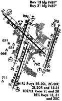
Runways
Runway Summary
| Runways: | 02C/20C 02L/20R 02R/20L 13/31 |
| Longest Runway: | 13/31 is 11030 ft (3362 m) long |
| Runways with an Instrument Approach: | 02C, 02L, 20R, 02R, 20L, 31 |
BNA Airport Runway Details
| Runway 02C/20C | 8001 ft x 150 ft (2439 m x 46 m) | |
| Runway Length Source: | 3RD PARTY SURVEY as of 07/20/2018 | |
| Surface: | Concrete - Good condition - Saw-cut or plastic grooved | |
| Runway Pavement Class: | 52 /R/B/W/T | |
| Runway Edge Lights: | High Intensity | |
Runway Weight Bearing Capacity (in thousands of pounds) |
||
| Single Wheel Landing Gear: | 75.0 | |
| Dual Wheel Landing Gear: | 209.0 | |
| Dual Tandem Wheel Landing Gear: | 350.0 | |
Runway 02C |
Runway 20C |
|
Elevation: |
569.1 | 571.8 |
Latitude: |
36-06-11.9899N | 36-07-27.2406N |
Longitude: |
086-41-16.6591W | 086-40-46.5500W |
|
Runway True Alignment: |
018 | 198 |
ILS Type: |
LOC/GS | |
Glide Path Angle: |
0.0 degrees | 3.0 degrees |
Traffic Pattern: |
Left | Left |
Runway Markings Type: |
Precision Instrument | Precision Instrument |
Runway Markings Condition: |
Good | Good |
Object Height: |
32 | |
Distance from End: |
850 | |
Object Centerline Offset: |
0 ft. left and right of centerline | |
Visual Glide Slope Indicators: |
4-Light PAPI On Left Side Of Runway | |
Runway Visual Range (RVR): |
Touchdown | Rollout |
Approach Light System: |
1,400 Foot Medium Intensity Approach Lighting System With Runway Alignment Indicator Lights | |
REIL: |
Yes | |
Threshold Crossing Height: |
68 | |
Declared Distances |
||
Take Off Run Avbl. (TORA): |
8001 | 8001 |
Take Off Distance Avbl. (TODA): |
8001 | 8001 |
Actual Stop Dist. Avbl. (ASDA): |
7601 | 8001 |
Landing Dist. Avbl. (LDA): |
7601 | 8001 |
| Runway 02L/20R | 7704 ft x 150 ft (2348 m x 46 m) | |
| Runway Length Source: | 3RD PARTY SURVEY as of 07/20/2018 | |
| Surface: | Concrete - Good condition - Saw-cut or plastic grooved | |
| Runway Pavement Class: | 71 /R/B/W/T | |
| Runway Edge Lights: | High Intensity | |
Runway Weight Bearing Capacity (in thousands of pounds) |
||
| Single Wheel Landing Gear: | 100.0 | |
| Dual Wheel Landing Gear: | 200.0 | |
| Dual Tandem Wheel Landing Gear: | 390.0 | |
| Dual Dual Tandem Wheel Landing Gear: | 850.0 | |
Runway 02L |
Runway 20R |
|
Elevation: |
598.7 | 555.6 |
Latitude: |
36-07-03.6342N | 36-08-16.2324N |
Longitude: |
086-41-11.3105W | 086-40-42.8335W |
|
Runway True Alignment: |
018 | 198 |
ILS Type: |
ILS/DME | ILS |
Glide Path Angle: |
3.0 degrees | 3.0 degrees |
Traffic Pattern: |
Left | Left |
Runway Markings Type: |
Precision Instrument | Precision Instrument |
Runway Markings Condition: |
Good | Good |
Object Centerline Offset: |
0 ft. left and right of centerline | |
Visual Glide Slope Indicators: |
4-Light PAPI On Right Side Of Runway | 4-Light PAPI On Right Side Of Runway |
Runway Visual Range (RVR): |
Touchdown, Rollout | Touchdown, Rollout |
Approach Light System: |
Standard 2,400 Foot High Intensity Approach Lighting System With Sequenced Flashers, Cat. II or III Config. | 1,400 Foot Medium Intensity Approach Lighting System With Sequenced Flashers |
Touchdown Lights: |
Yes | No |
Centerline Lights: |
Yes | Yes |
Threshold Crossing Height: |
55 | 79 |
Declared Distances |
||
Take Off Run Avbl. (TORA): |
7702 | 7702 |
Take Off Distance Avbl. (TODA): |
7702 | 7702 |
Actual Stop Dist. Avbl. (ASDA): |
7702 | 7702 |
Landing Dist. Avbl. (LDA): |
7702 | 7702 |
| Runway 02R/20L | 8001 ft x 150 ft (2439 m x 46 m) | |
| Runway Length Source: | 3RD PARTY SURVEY as of 07/20/2018 | |
| Surface: | Concrete - Good condition - Saw-cut or plastic grooved | |
| Runway Pavement Class: | 59 /R/B/W/T | |
| Runway Edge Lights: | High Intensity | |
Runway Weight Bearing Capacity (in thousands of pounds) |
||
| Single Wheel Landing Gear: | 75.0 | |
| Dual Wheel Landing Gear: | 209.0 | |
| Dual Tandem Wheel Landing Gear: | 350.0 | |
Runway 02R |
Runway 20L |
|
Elevation: |
589.8 | 540.0 |
Latitude: |
36-06-45.7670N | 36-08-01.0116N |
Longitude: |
086-40-03.5138W | 086-39-33.3955W |
|
Runway True Alignment: |
018 | 198 |
ILS Type: |
ILS/DME | ILS/DME |
Glide Path Angle: |
0.0 degrees | 0.0 degrees |
Runway Markings Type: |
Precision Instrument | Precision Instrument |
Runway Markings Condition: |
Good | Good |
Object Centerline Offset: |
0 ft. left and right of centerline | |
Runway Visual Range (RVR): |
Touchdown, Midfield, Rollout | Touchdown, Midfield, Rollout |
Approach Light System: |
Standard 2,400 Foot High Intensity Approach Lighting System With Sequenced Flashers, Cat. II or III Config. | 1,400 Foot Medium Intensity Approach Lighting System With Runway Alignment Indicator Lights |
Touchdown Lights: |
Yes | No |
Centerline Lights: |
Yes | Yes |
Declared Distances |
||
Take Off Run Avbl. (TORA): |
8000 | 8000 |
Take Off Distance Avbl. (TODA): |
8000 | 8000 |
Actual Stop Dist. Avbl. (ASDA): |
8000 | 8000 |
Landing Dist. Avbl. (LDA): |
8000 | 8000 |
| Runway 13/31 | 11030 ft x 150 ft (3362 m x 46 m) | |
| Runway Length Source: | 3RD PARTY SURVEY as of 07/20/2018 | |
| Surface: | Concrete - Good condition - Saw-cut or plastic grooved | |
| Runway Pavement Class: | 70 /R/C/W/T | |
| Runway Edge Lights: | High Intensity | |
Runway Weight Bearing Capacity (in thousands of pounds) |
||
| Single Wheel Landing Gear: | 75.0 | |
| Dual Wheel Landing Gear: | 175.0 | |
| Dual Tandem Wheel Landing Gear: | 250.0 | |
| Dual Dual Tandem Wheel Landing Gear: | 875.0 | |
Runway 13 |
Runway 31 |
|
Elevation: |
535.9 | 582.3 |
Latitude: |
36-08-28.5991N | 36-07-13.7852N |
Longitude: |
086-41-43.2788W | 086-40-05.4384W |
|
Runway True Alignment: |
133 | 313 |
ILS Type: |
ILS | |
Glide Path Angle: |
0.0 degrees | 3.0 degrees |
Traffic Pattern: |
Left | Left |
Runway Markings Type: |
Precision Instrument | Precision Instrument |
Runway Markings Condition: |
Good | Good |
Object at End: |
TREES | TREE |
Object Centerline Offset: |
0 ft. left and right of centerline | |
Visual Glide Slope Indicators: |
4-Light PAPI On Right Side Of Runway | |
REIL: |
Yes | Yes |
Threshold Crossing Height: |
51 | |
Threshold Elevation: |
543.4 | 577.5 |
Displaced Threshold: |
800 | 741 |
Threshold Latitude: |
36-08-23.1706N | 36-07-18.8113N |
Threshold Longitude: |
086-41-36.1767W | 086-40-12.0090W |
Declared Distances |
||
Take Off Run Avbl. (TORA): |
10288 | 10228 |
Take Off Distance Avbl. (TODA): |
11029 | 11029 |
Actual Stop Dist. Avbl. (ASDA): |
10288 | 10228 |
Landing Dist. Avbl. (LDA): |
9487 | 9487 |
Services
Airframe Repair: |
Major |
Powerplant Repair: |
Major |
Bottled Oxygen: |
None |
Bulk Oxygen: |
None |
Fuel Available: |
100LL, Jet A+ |
Landing Fees: |
No |
Parking: |
Hangars and tiedowns available |
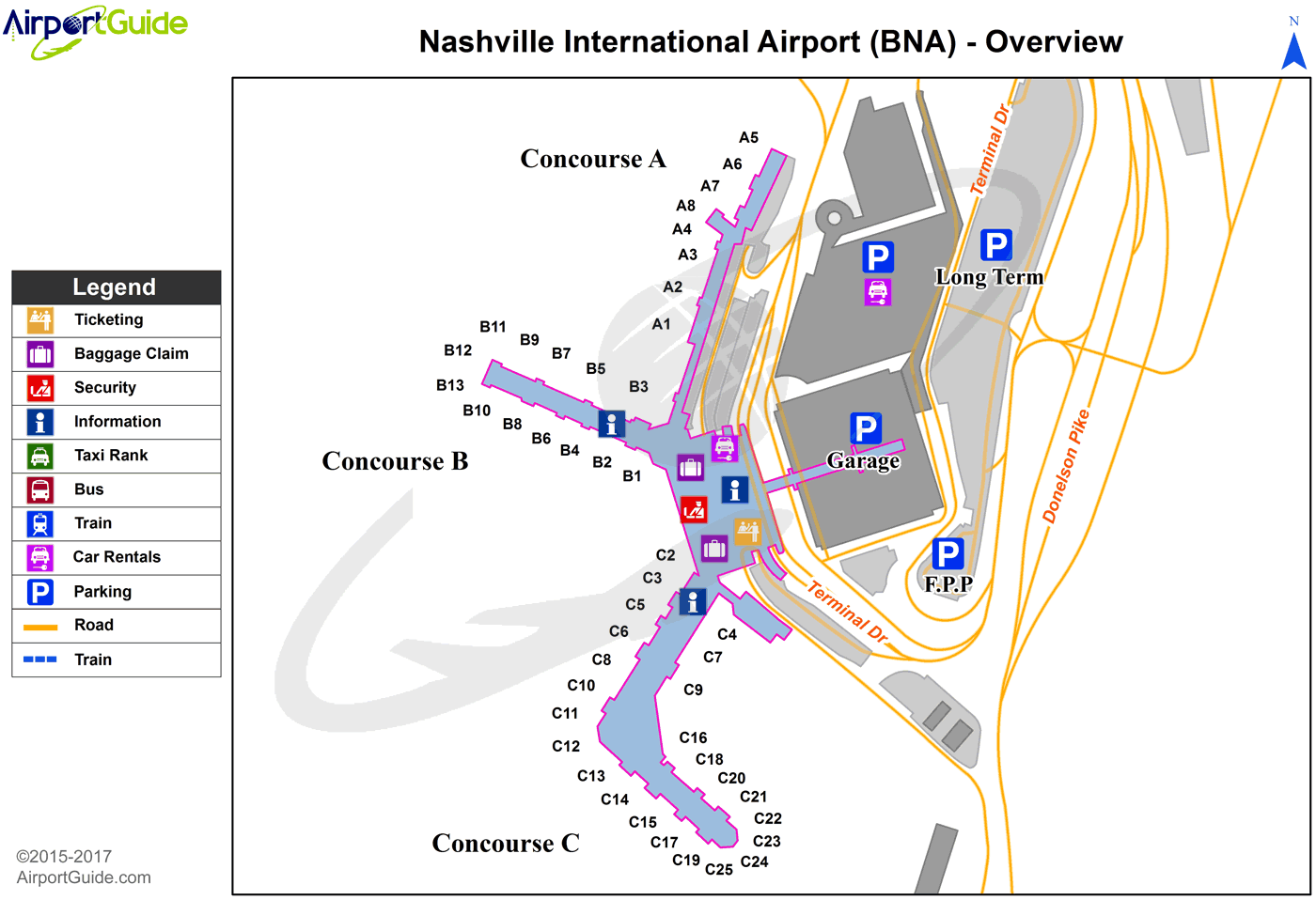
Maps & Diagrams
BNA Sectional
Flight Planning
at skyvector.com
at skyvector.com