Location
Latitude: |
43-45-58.0935N (43.766137) |
Longitude: |
099-19-16.4251W (-99.321229) |
Elevation: |
1696.3 feet MSL (517 m MSL) |
Magnetic Variation: |
4.5 E (as of April 2024 from WMM2020 model) |
Time Zone: |
UTC -6.0 (Standard Time) UTC -5.0 (Daylight Savings Time) |
From City: |
03 N.M. S of Chamberlain, South Dakota |
Found On: |
Omaha Chart |
FAA Region: |
AGL |
Contacts
Manager: |
Publicly owned: |
| DUSTEN HRABE 101 AIRPORT ROAD CHAMBERLAIN, SD 57325 605-680-9935 |
CITY OF CHAMBERLAIN 715 N. MAIN ST. CHAMBERLAIN, SD 57325 605-680-9935 |
Operations
Airport Status: |
Operational |
Facility Use: |
Public |
Type: |
Airport |
Activation Date: |
05/1981 |
Control tower: |
No |
Attendance (Months/Days/Hours): |
Months/Days/Hours ALL/ALL/ALL |
Boundary ARTCC: |
ZMP (Minneapolis) |
Responsible ARTCC: |
ZMP (Minneapolis) |
Lighting Schedule: |
SEE RMK |
Segmented Circle Indicator: |
Yes |
Traffic Pattern Altitude (MSL): |
2696 feet (822 m) |
NOTAMs Facility: |
9V9 |
NOTAM-D Service: |
Yes |
Based Aircraft
| Single Engine: | 11 |
Annual Operations (as of 08/31/2022)
| Total Operations: | 7512 | |
| Air Taxi: | 6 | 0.1% |
| GA Local: | 6500 | 86.5% |
| GA Itinerant: | 1000 | 13.3% |
| Military Aircraft: | 6 | 0.1% |
Communications
| CTAF: | 122.800 |
| Unicom: | 122.800 |
| AWOS-3P: | 118.025 (605-234-1437) |
- APCH/DEP SVC PRVDD BY MINNEAPOLIS ARTCC ON FREQS 125.1/269.1 (PIERRE RCAG).
Fixed Based Operators (FBOs) & Fuel
(Click on a business for detail)
Please help us keep this information up to date. This is a FREE SERVICE just like everything else on Airport Guide! If you see that a business needs to be added, modified, or deleted please fill out our Update Form.
To add, modify, or delete a business click here.
Please help us keep this information up to date. This is a FREE SERVICE just like everything else on Airport Guide! If you see that a business needs to be added, modified, or deleted please fill out our Update Form.
Area Code: 605 |
| Business Name | Frequency | Phone | Fuel Grade |
|---|---|---|---|
| Agri Air
Update FBO info |
734-5881, -5401 | 80, 100LL | |
| Creamer Aviation
Update FBO info |
734-5365 | 100LL, MOGAS |
Flight Service Stations
| Primary | Alternate | |
| FSS on Field: | N | |
| FSS Name (ID): | Huron(HON) | |
| Frequency: | ||
| Toll Free Phone: | 1-800-WX-BRIEF |
Instrument Procedures / Charts
FAA Terminal Procedures valid from 0901Z 03/21/24 to 0901Z 04/18/24.
There are various types of charts available for an airport. They are listed in the Page Type column. Here is a legend for those types:
APD - Airport Diagram
DP - Departure Procedure Charts
HOT - Hot Spots
IAP - Instrument Approach Procedure Charts
MIN - Minimums
STAR - Standard Terminal Arrival Charts
| Page Type | Page Name | Volume | Action Since Last Cycle |
|---|---|---|---|
| IAP | RNAV (GPS) RWY 13 | NC-1 | |
| IAP | RNAV (GPS) RWY 31 | NC-1 | |
| MIN | TAKEOFF MINIMUMS | NC-1 |
Terminal Procedures are only available for airports in several countries with more being added all the time. If you are looking for a specific country's charts, please send an email to support(at)airportguide.com stating the country name. This will be used to prioritize the implementation.
Navigation Aids (Navaids) near 9V9
| Dist (NM) | ID | Morse Code | Name | Type | Freq | True Hdg | Mag Hdg |
|---|---|---|---|---|---|---|---|
| 25.4 | ISD | . . . . . _ . . | Winner | VOR | 112.80 | 229 | 224 |
| 52.3 | PIR | . _ _ . . . . _ . | Pierre | VORTAC | 113.75 | 316 | 311 |
| 55.6 | MHE | _ _ . . . . . | Mitchell | VOR-DME | 109.20 | 88 | 84 |
| 58.8 | HO | . . . . _ _ _ | Beady | NDB | 302 | 45 | 41 |
| 59.4 | HON | . . . . _ _ _ _ . | Huron | DME | 117.6 | 46 | 42 |
| 61.5 | AGZ | . _ _ _ . _ _ . . | Wagner | NDB | 392 | 132 | 128 |
| 72.4 | RBE | . _ . _ . . . . | Rock County | NDB | 341 | 189 | 184 |
| 76.3 | VTN | . . . _ _ _ . | Valentine | NDB | 314 | 225 | 220 |
| 77.6 | ANW | . _ _ . . _ _ | Ainsworth | VOR-DME | 112.70 | 202 | 197 |
| 82.6 | ONL | _ _ _ _ . . _ . . | O'neill | VORTAC | 113.90 | 160 | 156 |
| 97.7 | MDS | _ _ _ . . . . . | Wentworth | NDB | 400 | 80 | 76 |
| 98.6 | YKN | _ . _ _ _ . _ _ . | Yankton | DME | 111.4 | 120 | 116 |
Nearby Airports with Fuel
Notices to Airmen (NOTAMS)
Remarks
| A110-1 | WATERFOWL ON & INVOF ARPT. |
| A110-3 | GCO AVBL ON FREQ 121.725 ( 4 CLICKS TO MINNEAPOLIS CENTER AND 6 CLIKCS TO FLIGHT SERVICES) |
| A110-4 | FOR CD IF UNA VIA GCO CTC MINNEAPOLIS ARTCC AT 651-463-5588. |
| A42-18 | MKD WITH WHITE/BLACK TIPPED MKR CONES. |
| A42-36 | MKD WITH WHITE/BLACK TIPPED MKR CONES. |
| A70-FUEL-10 | 0LL FUEL AVBL 24 HRS WITH CREDIT CARD. |
| A81-APT | MIRL RY 13/31 PRESET ON LOW INTST, TO INCR INTST & ACTVT PAPI RYS 13 & 31 - CTAF. |
Runways
Runway Summary
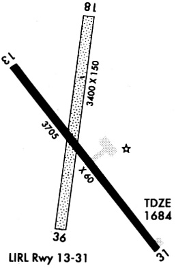
| Runways: | 13/31 18/36 |
| Longest Runway: | 13/31 is 4299 ft (1310 m) long |
| Runways with an Instrument Approach: |
9V9 Airport Runway Details
| Runway 13/31 | 4299 ft x 75 ft (1310 m x 23 m) | |
| Runway Length Source: | 3RD PARTY SURVEY as of 02/09/2009 | |
| Surface: | Asphalt - Fair condition - No special surface treatment | |
| Runway Edge Lights: | Medium Intensity | |
Runway Weight Bearing Capacity (in thousands of pounds) |
||
| Single Wheel Landing Gear: | 12.5 | |
Runway 13 |
Runway 31 |
|
Elevation: |
1696.3 | 1678.1 |
Latitude: |
43-46-13.0298N | 43-45-40.0588N |
Longitude: |
099-19-35.0766W | 099-18-58.1807W |
|
Runway True Alignment: |
141 | 321 |
Glide Path Angle: |
3.0 degrees | 3.0 degrees |
Runway Markings Type: |
Nonprecision Instrument | Nonprecision Instrument |
Runway Markings Condition: |
Fair | Fair |
Object at End: |
TREE | |
Object Height: |
64 | |
Distance from End: |
1539 | |
Object Centerline Offset: |
415 ft. left of centerline | |
Visual Glide Slope Indicators: |
2-Light PAPI On Left Side Of Runway | 2-Light PAPI On Left Side Of Runway |
REIL: |
No | No |
Touchdown Lights: |
No | No |
Centerline Lights: |
No | No |
Threshold Crossing Height: |
40 | 40 |
| Runway 18/36 | 3403 ft x 150 ft (1037 m x 46 m) | |
| Runway Length Source: | 3RD PARTY SURVEY as of 02/09/2009 | |
| Surface: | Asphalt - Fair condition - No special surface treatment | |
Runway 18 |
Runway 36 |
|
Elevation: |
1696.0 | 1680.0 |
Latitude: |
43-46-16.7251N | 43-45-43.3761N |
Longitude: |
099-19-13.3041W | 099-19-19.0319W |
|
Runway True Alignment: |
187 | 007 |
Glide Path Angle: |
0.0 degrees | 0.0 degrees |
Object at End: |
POLE | |
Object Height: |
46 | |
Distance from End: |
1000 | |
Object Centerline Offset: |
415 ft. left of centerline |
Services
Airframe Repair: |
None |
Powerplant Repair: |
None |
Bottled Oxygen: |
None |
Bulk Oxygen: |
None |
Fuel Available: |
100LL |
Landing Fees: |
No |
Parking: |
Hangars and tiedowns available |
Maps & Diagrams
9V9 Sectional
Flight Planning
at skyvector.com
at skyvector.com