Location
Latitude: |
42-33-45.7160N (42.562699) |
Longitude: |
099-02-19.7170W (-99.03881) |
Elevation: |
2131.0 feet MSL (650 m MSL) |
Magnetic Variation: |
4.3 E (as of April 2024 from WMM2020 model) |
Time Zone: |
UTC -6.0 (Standard Time) UTC -5.0 (Daylight Savings Time) |
From City: |
03 N.M. NW of Atkinson, Nebraska |
Found On: |
Omaha Chart |
FAA Region: |
ACE |
Contacts
Manager: |
Publicly owned: |
| JACK FLANNERY PO BOX 83 ATKINSON, NE 68713-0083 402-340-0388 |
STUART ATKINSON AIRPORT AUTH P.O. BOX 265 STUART, NE 68780-0265 402-340-0388 |
Operations
Airport Status: |
Operational |
Facility Use: |
Public |
Type: |
Airport |
Activation Date: |
01/1949 |
Control tower: |
No |
Attendance (Months/Days/Hours): |
Months/Days/Hours Unattended |
Boundary ARTCC: |
ZMP (Minneapolis) |
Responsible ARTCC: |
ZMP (Minneapolis) |
Lighting Schedule: |
SEE RMK |
Segmented Circle Indicator: |
Yes |
Traffic Pattern Altitude (MSL): |
3131 feet (954 m) |
NOTAMs Facility: |
OLU |
NOTAM-D Service: |
Yes |
International Airport of Entry: |
No |
Customs Landing Rights: |
No |
Military Landing Rights: |
No |
Civil/Military Joint Use: |
No |
Based Aircraft
| Single Engine: | 10 |
| GA Helicopters: | 1 |
Annual Operations (as of 05/27/2021)
| Total Operations: | 2900 | |
| GA Local: | 2000 | 69.0% |
| GA Itinerant: | 900 | 31.0% |
Communications
| CTAF: | 122.900 |
- APCH/DEP SVC PRVDD BY MINNEAPOLIS ARTCC ON FREQS 128.0/257.95 (O'NEILL RCAG).
Fixed Based Operators (FBOs) & Fuel
(Click on a business for detail)
Please help us keep this information up to date. This is a FREE SERVICE just like everything else on Airport Guide! If you see that a business needs to be added, modified, or deleted please fill out our Update Form.
To add, modify, or delete a business click here.
Please help us keep this information up to date. This is a FREE SERVICE just like everything else on Airport Guide! If you see that a business needs to be added, modified, or deleted please fill out our Update Form.
Area Code: 402 |
| Business Name | Frequency | Phone | Fuel Grade |
|---|
Flight Service Stations
| Primary | Alternate | |
| FSS on Field: | N | |
| FSS Name (ID): | Columbus(OLU) | |
| Frequency: | ||
| Toll Free Phone: | 1-800-WX-BRIEF |
Instrument Procedures / Charts
FAA Terminal Procedures valid from 0901Z 03/21/24 to 0901Z 04/18/24.
There are various types of charts available for an airport. They are listed in the Page Type column. Here is a legend for those types:
APD - Airport Diagram
DP - Departure Procedure Charts
HOT - Hot Spots
IAP - Instrument Approach Procedure Charts
MIN - Minimums
STAR - Standard Terminal Arrival Charts
| Page Type | Page Name | Volume | Action Since Last Cycle |
|---|---|---|---|
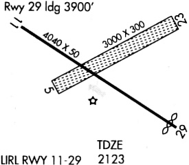
| IAP | RNAV (GPS) RWY 11 | NC-2 | |
| IAP | RNAV (GPS) RWY 29 | NC-2 | |
| MIN | TAKEOFF MINIMUMS | NC-2 |
Terminal Procedures are only available for airports in several countries with more being added all the time. If you are looking for a specific country's charts, please send an email to support(at)airportguide.com stating the country name. This will be used to prioritize the implementation.
Navigation Aids (Navaids) near 8V2
| Dist (NM) | ID | Morse Code | Name | Type | Freq | True Hdg | Mag Hdg |
|---|---|---|---|---|---|---|---|
| 16.5 | ONL | _ _ _ _ . . _ . . | O'neill | VORTAC | 113.90 | 109 | 105 |
| 23.8 | RBE | . _ . _ . . . . | Rock County | NDB | 341 | 271 | 267 |
| 42.0 | ANW | . _ _ . . _ _ | Ainsworth | VOR-DME | 112.70 | 270 | 265 |
| 44.5 | AGZ | . _ _ _ . _ _ . . | Wagner | NDB | 392 | 47 | 43 |
| 47.5 | BUB | _ . . . . . _ _ . . . | Burwell | NDB | 377 | 185 | 181 |
| 56.5 | ODX | _ _ _ _ . . _ . . _ | Ord | NDB | 356 | 175 | 171 |
| 63.9 | ISD | . . . . . _ . . | Winner | VOR | 112.80 | 330 | 325 |
| 66.5 | BVN | _ . . . . . . _ _ . | Alaby | NDB | 332 | 138 | 134 |
| 69.0 | VTN | . . . _ _ _ . | Valentine | NDB | 314 | 285 | 280 |
| 70.9 | CUZ | _ . _ . . . _ _ _ . . | Custer County | VOR-DME | 108.20 | 204 | 200 |
| 75.9 | YKN | _ . _ _ _ . _ _ . | Yankton | DME | 111.4 | 73 | 69 |
| 77.5 | OBH | _ _ _ _ . . . . . . . | Wolbach | DME | 112 | 156 | 152 |
| 78.4 | YK | _ . _ _ _ . _ | Cagur | NDB | 347 | 76 | 72 |
| 79.1 | OFK | _ _ _ . . _ . _ . _ | Norfolk | VOR-DME | 109.60 | 115 | 111 |
| 80.2 | OF | _ _ _ . . _ . | Carsy | NDB | 510 | 119 | 115 |
| 82.3 | TDD | _ _ . . _ . . | Thedford | VOR-DME | 108.60 | 245 | 240 |
| 85.0 | MHE | _ _ . . . . . | Mitchell | VOR-DME | 109.20 | 30 | 26 |
| 97.7 | PLT | . _ _ . . _ . . _ | Platte Center | NDB | 407 | 130 | 126 |
Nearby Airports with Fuel
Notices to Airmen (NOTAMS)
Remarks
| A110-1 | FOR CD CTC MINNEAPOLIS ARTCC AT 651-463-5588. |
| A32-05/23 | NARROWED TO 100', CENTERLINE STAYED THE SAME. |
| A42-05 | NSTD MKGS RY 05/23 MARKED WITH YELLOW CONES. |
| A70-FUEL-10 | 0LL FOR FUEL CALL (402) 925-5527 OR (402) 340-0388. |
| A81-APT | MIRL RY 11/29 PRESET MED INTST SS-SR, TO INCR INTST & ACTVT- CTAF. |
| E111 | PROVIDED THAT THE APCH TO EACH RWY IS MAINTAINED FOR A MINIMUM 20:1 GLIDE SLOPE AND THE TRANSITIONAL SURFACE BE MAINTAINED FOR A 7:1 SLOPE. |
Runways
Runway Summary
| Runways: | 05/23 11/29 |
| Longest Runway: | 11/29 is 3900 ft (1189 m) long |
| Runways with an Instrument Approach: |
8V2 Airport Runway Details
| Runway 05/23 | 2970 ft x 100 ft (905 m x 30 m) | |
| Surface: | Turf - Fair condition - No special surface treatment | |
Runway 05 |
Runway 23 |
|
Elevation: |
2121.8 | 2127.4 |
Latitude: |
42-33-38.2400N | 42-33-53.0600N |
Longitude: |
099-02-28.3300W | 099-01-54.0760W |
|
Runway True Alignment: |
060 | 240 |
Glide Path Angle: |
0.0 degrees | 0.0 degrees |
Traffic Pattern: |
Left | Left |
Runway Markings Type: |
Nonstandard (other than numbers only) | Nonstandard (other than numbers only) |
Object at End: |
ROAD | ROAD |
Object Height: |
16 | 14 |
Distance from End: |
366 | 327 |
Object Centerline Offset: |
161 ft. right of centerline | 155 ft. right of centerline |
| Runway 11/29 | 3900 ft x 60 ft (1189 m x 18 m) | |
| Runway Length Source: | STATE as of 11/02/2011 | |
| Surface: | Turf - Fair condition - No special surface treatment | |
| Runway Edge Lights: | Medium Intensity | |
Runway Weight Bearing Capacity (in thousands of pounds) |
||
| Single Wheel Landing Gear: | 12.5 | |
Runway 11 |
Runway 29 |
|
Elevation: |
2131.3 | 2126.1 |
Latitude: |
42-33-55.2981N | 42-33-36.2319N |
Longitude: |
099-02-48.8427W | 099-02-03.5591W |
|
Runway True Alignment: |
120 | 300 |
Glide Path Angle: |
0.0 degrees | 0.0 degrees |
Traffic Pattern: |
Left | Left |
Runway Markings Type: |
Nonprecision Instrument | Nonprecision Instrument |
Runway Markings Condition: |
Good | Good |
Object at End: |
POLE | |
Object Height: |
29 | |
Distance from End: |
1024 | |
Object Centerline Offset: |
161 ft. right of centerline | 155 ft. right of centerline |
Services
Airframe Repair: |
Major |
Powerplant Repair: |
Major |
Bottled Oxygen: |
None |
Bulk Oxygen: |
None |
Fuel Available: |
100LL, Jet A |
Landing Fees: |
No |
Parking: |
Hangars and tiedowns available |
Maps & Diagrams
8V2 Sectional
Flight Planning
at skyvector.com
at skyvector.com