Location
Latitude: |
39-53-04.2290N (39.884508) |
Longitude: |
082-35-20.5840W (-82.589051) |
Elevation: |
930.0 feet MSL (283 m MSL) |
Magnetic Variation: |
7.5 W (as of April 2024 from WMM2020 model) |
Time Zone: |
UTC -5.0 (Standard Time) UTC -4.0 (Daylight Savings Time) |
From City: |
03 N.M. NE of Baltimore, Ohio |
Found On: |
Cincinnati Chart |
FAA Region: |
AGL |
Contacts
Manager: |
Privately owned: |
| CLARENCE 'BUTCH' PRICE 155 STEMEN RD NW BALTIMORE, OH 43105-9692 740-862-8422 |
EDWARD MILLER 455 STEMEN RD NW BALTIMORE, OH 43105-9626 614-862-8129 |
Operations
Airport Status: |
Operational |
Facility Use: |
Public |
Type: |
Airport |
Activation Date: |
06/1963 |
Control tower: |
No |
Attendance (Months/Days/Hours): |
Months/Days/Hours ALL/ALL/SR-SS |
Boundary ARTCC: |
ZID (Indianapolis) |
Responsible ARTCC: |
ZID (Indianapolis) |
Lighting Schedule: |
SEE RMK |
Segmented Circle Indicator: |
No |
Traffic Pattern Altitude (MSL): |
1930 feet (588 m) |
NOTAMs Facility: |
DAY |
NOTAM-D Service: |
Yes |
International Airport of Entry: |
No |
Customs Landing Rights: |
No |
Military Landing Rights: |
No |
Civil/Military Joint Use: |
No |
Based Aircraft
| Single Engine: | 1 |
Annual Operations (as of 08/06/2020)
| Total Operations: | 350 | |
| GA Local: | 300 | 85.7% |
| GA Itinerant: | 50 | 14.3% |
Communications
| CTAF: | 122.900 |
Fixed Based Operators (FBOs) & Fuel
(Click on a business for detail)
Please help us keep this information up to date. This is a FREE SERVICE just like everything else on Airport Guide! If you see that a business needs to be added, modified, or deleted please fill out our Update Form.
To add, modify, or delete a business click here.
Please help us keep this information up to date. This is a FREE SERVICE just like everything else on Airport Guide! If you see that a business needs to be added, modified, or deleted please fill out our Update Form.
Area Code: 614 |
| Business Name | Frequency | Phone | Fuel Grade |
|---|---|---|---|
| Ken Alspaugh
Update FBO info |
862-6053 |
Flight Service Stations
| Primary | Alternate | |
| FSS on Field: | N | |
| FSS Name (ID): | Dayton(DAY) | |
| Frequency: | ||
| Toll Free Phone: | 1-800-WX-BRIEF |
Instrument Procedures / Charts
Terminal Procedures are only available for airports in several countries with more being added all the time. If you are looking for a specific country's charts, please send an email to support(at)airportguide.com stating the country name. This will be used to prioritize the implementation.
Navigation Aids (Navaids) near 7B4
| Dist (NM) | ID | Morse Code | Name | Type | Freq | True Hdg | Mag Hdg |
|---|---|---|---|---|---|---|---|
| 9.8 | CM | _ . _ . _ _ | Sumie | NDB | 391 | 308 | 315 |
| 10.3 | HEH | . . . . . . . . . | Newark | NDB | 524 | 34 | 42 |
| 11.4 | LC | . _ . . _ . _ . | Pickl | NDB | 376 | 269 | 276 |
| 15.1 | CMH | _ . _ . _ _ . . . . | Port Columbus | VOT | 111.00 | 295 | 302 |
| 16.0 | APE | . _ . _ _ . . | Appleton | VORTAC | 116.70 | 0 | 8 |
| 16.3 | LCK | . _ . . _ . _ . _ . _ | Rickenbacker | TACAN | 69X | 253 | 260 |
| 21.6 | CHC | _ . _ . . . . . _ . _ . | Grens | NDB | 272 | 290 | 297 |
| 21.6 | DD | _ . . _ . . | Cobbs | NDB | 253 | 247 | 254 |
| 28.0 | XUB | _ . . _ . . _ _ . . . | Yellow Bud | VOR | 112.50 | 220 | 227 |
| 28.6 | BU | _ . . . . . _ | Boutn | NDB | 230 | 262 | 269 |
| 30.2 | OS | _ _ _ . . . | Fuler | NDB | 515 | 292 | 299 |
| 30.9 | HRA | . . . . . _ . . _ | Zanesville | NDB | 204 | 87 | 95 |
| 32.2 | ZZV | _ _ . . _ _ . . . . . _ | Zanesville | VOR-DME | 114.95 | 83 | 91 |
| 33.6 | RZT | . _ . _ _ . . _ | Ross County | NDB | 236 | 217 | 224 |
| 40.7 | CSS | _ . _ . . . . . . . | Court House | NDB | 414 | 245 | 252 |
| 43.3 | UGS | . . _ _ _ . . . . | University | NDB | 250 | 150 | 158 |
| 43.5 | UNI | . . _ _ . . . | Athens | FAN MARKER | 155 | 163 | |
| 45.9 | EOP | . _ _ _ . _ _ . | Waverly | NDB | 385 | 200 | 207 |
| 49.0 | BUD | _ . . . . . _ _ . . | Buckeye | VOR | 109.80 | 333 | 340 |
| 51.3 | MLR | _ _ . _ . . . _ . | Millersburg/Dcmsnd | NDB | 382 | 39 | 47 |
Nearby Airports with Fuel
Notices to Airmen (NOTAMS)
Remarks
| A110-1 | NO STUDENT OPS. |
| A110-3 | OCNL UAS OPRG FM ARPT, CTAF MNTD, OVERFLY FLD TO ENTER TFC PAT. |
| A110-4 | FOR CD CTC COLUMBUS APCH AT 614-338-8537. |
| A110-5 | OCNL DEER, BIRDS, & OTR WILDLIFE ON & INVOF ARPT. |
| A14 | BUTCH.NANCY@OUTLOOK.COM. |
| A40-09/27 | NSTD LIRL DUE TO RWY ENDS LGTD WITH SPLIT RED & GREEN LGTS & DTHRS LGTD WITH 1 SPLIT RED & GREEN LGT EACH SIDE OF RWY. |
| A51-09 | DTHR MKD WITH GREEN LGT ON WHITE MKR. |
| A51-27 | DTHR MKD WITH GREEN LGT ON WHITE MKR. |
| A57-09 | APCH SLP 6:1 DUE TO 110 FT TREES, 675 FT DIST, 125 FT L & R, OBST CLNC SLP 8:1 TO DTHR; OBST CLNC SLP 0:1 TO DTHR DUE TO +8 FT CROPS, 0 FT DIST, 50 FT L & R. |
| A57-27 | APCH SLP 1:1 DUE TO +15 FT ROAD, 20 FT DIST, 125 FT L & R, OBST CLNC SLP 19:1 TO DTHR; OBST CLNC SLP 0:1 TO DTHR DUE TO +8 FT CROPS, 0 FT DIST, 50 FT L & R. |
| A75 | PRIOR CDN RQRD. |
| A81-APT | ACTVT NSTD LIRL - CALL AMGR. |
| E111 | VFR USE ONLY. |
Runways
Runway Summary
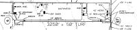
| Runways: | 09/27 |
| Longest Runway: | 09/27 is 3250 ft (991 m) long |
| Runways with an Instrument Approach: |
7B4 Airport Runway Details
| Runway 09/27 | 3250 ft x 50 ft (991 m x 15 m) | |
| Surface: | Turf - Good condition - No special surface treatment | |
| Runway Edge Lights: | Non-standard lighting system Intensity | |
Runway 09 |
Runway 27 |
|
Glide Path Angle: |
0.0 degrees | 0.0 degrees |
Traffic Pattern: |
Left | Left |
Object at End: |
TREES | ROAD |
Object Height: |
110 | 15 |
Distance from End: |
675 | 20 |
Object Centerline Offset: |
125 ft. left and right of centerline | 125 ft. left and right of centerline |
Displaced Threshold: |
270 | 275 |
Services
Airframe Repair: |
Major |
Powerplant Repair: |
Major |
Bottled Oxygen: |
None |
Bulk Oxygen: |
None |
Fuel Available: |
100LL, Jet A-1+ |
Landing Fees: |
No |
Parking: |
Tiedowns available |
Maps & Diagrams
7B4 Sectional
Flight Planning
at skyvector.com
at skyvector.com