Location
Latitude: |
34-24-29.6000N (34.408222) |
Longitude: |
086-55-58.6000W (-86.932944) |
Elevation: |
628.5 feet MSL (192 m MSL) |
Magnetic Variation: |
3.9 W (as of April 2024 from WMM2020 model) |
Time Zone: |
UTC -6.0 (Standard Time) UTC -5.0 (Daylight Savings Time) |
From City: |
02 N.M. S of Hartselle, Alabama |
Found On: |
Atlanta Chart |
FAA Region: |
ASO |
Contacts
Manager: |
Publicly owned: |
| STONEY POWELL 450 AIRPORT RD SW HARTSELLE, AL 35640 256-773-1130 |
CITY OF HARTSELLE 200 SPARKMAN ST, NW HARTSELLE, AL 35640 256-773-2535 |
Operations
Airport Status: |
Operational |
Facility Use: |
Public |
Type: |
Airport |
Activation Date: |
09/1965 |
Control tower: |
No |
Attendance (Months/Days/Hours): |
Months/Days/Hours ALL/ALL/0800-1700 |
Boundary ARTCC: |
ZME (Memphis) |
Responsible ARTCC: |
ZME (Memphis) |
Lighting Schedule: |
SEE RMK |
Segmented Circle Indicator: |
Yes |
Traffic Pattern Altitude (MSL): |
1628 feet (496 m) |
NOTAMs Facility: |
ANB |
NOTAM-D Service: |
Yes |
International Airport of Entry: |
No |
Customs Landing Rights: |
No |
Military Landing Rights: |
Yes |
Civil/Military Joint Use: |
No |
Based Aircraft
| Single Engine: | 17 |
Annual Operations (as of 06/30/2020)
| Total Operations: | 15295 | |
| GA Local: | 4375 | 28.6% |
| GA Itinerant: | 10920 | 71.4% |
Communications
| CTAF: | 122.800 |
| Unicom: | 122.800 |
| Approach: | HUNTSVILLE 118.05 118.05 MEMPHIS ARTCC |
| Departure: | HUNTSVILLE 118.05 118.05 MEMPHIS ARTCC |
- APCH/DEP SVC PRVDD BY MEMPHIS ARTCC ON FREQS 120.8/307.0 (HUNTSVILLE RCAG) WHEN HUNTSVILLE APCH CTL CLSD.
Fixed Based Operators (FBOs) & Fuel
(Click on a business for detail)
Please help us keep this information up to date. This is a FREE SERVICE just like everything else on Airport Guide! If you see that a business needs to be added, modified, or deleted please fill out our Update Form.
To add, modify, or delete a business click here.
Please help us keep this information up to date. This is a FREE SERVICE just like everything else on Airport Guide! If you see that a business needs to be added, modified, or deleted please fill out our Update Form.
Area Code: 256 |
| Business Name | Frequency | Phone | Fuel Grade |
|---|---|---|---|
| Blackstone Rotorcraft
Update FBO info |
Unicom 122.8 | 773-1130, 773-1137 | 100LL |
Flight Service Stations
| Primary | Alternate | |
| FSS on Field: | N | |
| FSS Name (ID): | Anniston(ANB) | |
| Frequency: | ||
| Toll Free Phone: | 1-800-WX-BRIEF |
Instrument Procedures / Charts
FAA Terminal Procedures valid from 0901Z 03/21/24 to 0901Z 04/18/24.
There are various types of charts available for an airport. They are listed in the Page Type column. Here is a legend for those types:
APD - Airport Diagram
DP - Departure Procedure Charts
HOT - Hot Spots
IAP - Instrument Approach Procedure Charts
MIN - Minimums
STAR - Standard Terminal Arrival Charts
| Page Type | Page Name | Volume | Action Since Last Cycle |
|---|---|---|---|
| IAP | RNAV (GPS) RWY 18 | SE-4 | |
| IAP | RNAV (GPS) RWY 36 | SE-4 | |
| MIN | TAKEOFF MINIMUMS | SE-4 |
Terminal Procedures are only available for airports in several countries with more being added all the time. If you are looking for a specific country's charts, please send an email to support(at)airportguide.com stating the country name. This will be used to prioritize the implementation.
Navigation Aids (Navaids) near 5M0
| Dist (NM) | ID | Morse Code | Name | Type | Freq | True Hdg | Mag Hdg |
|---|---|---|---|---|---|---|---|
| 14.4 | DCU | _ . . _ . _ . . . _ | Decatur | DME | 112.8 | 358 | 362 |
| 16.0 | HSV | . . . . . . . . . . _ | Huntsville | VOT | 111.00 | 29 | 33 |
| 21.2 | HUA | . . . . . . _ . _ | Redstone | NDB | 287 | 34 | 38 |
| 23.2 | CWH | _ . _ . . _ _ . . . . | Capshaw | NDB | 350 | 19 | 23 |
| 27.6 | RQZ | . _ . _ _ . _ _ _ . . | Rocket | VORTAC | 112.20 | 32 | 36 |
| 32.9 | MSL | _ _ . . . . _ . . | Muscle Shoals | DME | 116.25 | 303 | 307 |
| 36.4 | ARF | . _ . _ . . . _ . | Saratoga | NDB | 296 | 104 | 108 |
| 44.3 | VUZ | . . . _ . . _ _ _ . . | Vulcan | VORTAC | 114.40 | 177 | 181 |
| 47.6 | TNY | _ _ . _ . _ _ | Kelso | NDB | 358 | 23 | 27 |
| 49.5 | GAD | _ _ . . _ _ . . | Gadsden | VOR-DME | 112.30 | 121 | 125 |
| 51.5 | BHM | _ . . . . . . . _ _ | Birmingham Muni | VOT | 110.00 | 170 | 174 |
| 52.2 | LRT | . _ . . . _ . _ | Lawrenceburg | NDB | 269 | 342 | 346 |
| 54.0 | BH | _ . . . . . . . | Mcden | NDB | 224 | 175 | 179 |
| 54.9 | HAB | . . . . . _ _ . . . | Hamilton | DME | 110.4 | 257 | 261 |
| 62.7 | FTP | . . _ . _ . _ _ . | Fort Payne | NDB | 426 | 83 | 87 |
| 62.8 | BGF | _ . . . _ _ . . . _ . | Boiling Fork | NDB | 263 | 42 | 46 |
| 65.8 | LUG | . _ . . . . _ _ _ . | Verona | NDB | 251 | 5 | 9 |
| 66.8 | TDG | _ _ . . _ _ . | Talladega | DME | 108.8 | 138 | 142 |
| 67.4 | UXM | . . _ _ . . _ _ _ | Tullahoma Regional | VOR | 109.65 | 29 | 33 |
| 68.5 | SYI | . . . _ . _ _ . . | Bomar | FAN MARKER | 19 | 23 |
Nearby Airports with Fuel
Notices to Airmen (NOTAMS)
Remarks
| A110-1 | FOR CD CTC HUNTSVILLE APCH AT 256-542-2070, WHEN APCH CLSD CTC MEMPHIS ARTCC AT 901-368-8453/8449. |
| A16 | AFT HRS 256-303-2777. |
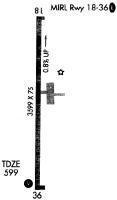
| A81-APT | ACTVT MIRL RY 18/36 & VASI RY 36 - CTAF. MIRL RY 18/36 PRESET HIGH INTST. |
Runways
Runway Summary
| Runways: | 18/36 |
| Longest Runway: | 18/36 is 3599 ft (1097 m) long |
| Runways with an Instrument Approach: |
5M0 Airport Runway Details
| Runway 18/36 | 3599 ft x 75 ft (1097 m x 23 m) | |
| Runway Length Source: | 3RD PARTY SURVEY as of 06/29/2011 | |
| Surface: | Asphalt - Good condition - No special surface treatment | |
| Runway Edge Lights: | Medium Intensity | |
Runway Weight Bearing Capacity (in thousands of pounds) |
||
| Single Wheel Landing Gear: | 20.0 | |
Runway 18 |
Runway 36 |
|
Elevation: |
628.5 | 598.3 |
Latitude: |
34-24-47.3974N | 34-24-11.8002N |
Longitude: |
086-55-58.3399W | 086-55-58.8622W |
|
Runway True Alignment: |
181 | 001 |
Glide Path Angle: |
0.0 degrees | 3.0 degrees |
Traffic Pattern: |
Left | Left |
Runway Markings Type: |
Nonprecision Instrument | Nonprecision Instrument |
Runway Markings Condition: |
Good | Good |
Object at End: |
TREE | TREE |
Object Height: |
58 | 87 |
Distance from End: |
425 | 700 |
Object Centerline Offset: |
149 ft. left of centerline | 194 ft. right of centerline |
Visual Glide Slope Indicators: |
2-Box VASI On Left Side Of Runway | |
Threshold Crossing Height: |
34 |
Services
Airframe Repair: |
Minor |
Powerplant Repair: |
Minor |
Fuel Available: |
100LL |
Landing Fees: |
No |
Parking: |
Hangars and tiedowns available |
Maps & Diagrams
5M0 Sectional
Flight Planning
at skyvector.com
at skyvector.com