Location
Latitude: |
32-47-18.6000N (32.7885) |
Longitude: |
093-00-13.1190W (-93.003644) |
Elevation: |
244.1 feet MSL (74 m MSL) |
Magnetic Variation: |
0.3 E (as of April 2024 from WMM2020 model) |
Time Zone: |
UTC -6.0 (Standard Time) UTC -5.0 (Daylight Savings Time) |
From City: |
03 N.M. E of Homer, Louisiana |
Found On: |
Memphis Chart |
FAA Region: |
ASW |
Contacts
Manager: |
Publicly owned: |
| JERRY WHITTON 550 AIRPORT LOOP, FIRE STATION HOMER, LA 71040 318-225-0911 |
CITY OF HOMER 400 EAST MAIN HOMER, LA 71040 318-927-3555 |
Operations
Airport Status: |
Operational |
Facility Use: |
Public |
Type: |
Airport |
Activation Date: |
01/1970 |
Control tower: |
No |
Attendance (Months/Days/Hours): |
Months/Days/Hours Unattended |
Boundary ARTCC: |
ZFW (Fort Worth) |
Responsible ARTCC: |
ZFW (Fort Worth) |
Lighting Schedule: |
SEE RMK |
Segmented Circle Indicator: |
Yes |
Traffic Pattern Altitude (MSL): |
1244 feet (379 m) |
NOTAMs Facility: |
DRI |
NOTAM-D Service: |
Yes |
International Airport of Entry: |
No |
Customs Landing Rights: |
No |
Military Landing Rights: |
Yes |
Civil/Military Joint Use: |
No |
Based Aircraft
| Single Engine: | 8 |
Annual Operations (as of 10/31/2018)
| Total Operations: | 1710 | |
| GA Local: | 960 | 56.1% |
| GA Itinerant: | 750 | 43.9% |
Communications
| CTAF: | 122.900 |
Fixed Based Operators (FBOs) & Fuel
(Click on a business for detail)
Please help us keep this information up to date. This is a FREE SERVICE just like everything else on Airport Guide! If you see that a business needs to be added, modified, or deleted please fill out our Update Form.
To add, modify, or delete a business click here.
Please help us keep this information up to date. This is a FREE SERVICE just like everything else on Airport Guide! If you see that a business needs to be added, modified, or deleted please fill out our Update Form.
Area Code: 318 |
| Business Name | Frequency | Phone | Fuel Grade |
|---|
Flight Service Stations
| Primary | Alternate | |
| FSS on Field: | N | |
| FSS Name (ID): | De Ridder(DRI) | |
| Frequency: | ||
| Toll Free Phone: | 1-800-WX-BRIEF |
Instrument Procedures / Charts
| Page Type | Page Name | Volume | Action Since Last Cycle |
|---|
Terminal Procedures are only available for airports in several countries with more being added all the time. If you are looking for a specific country's charts, please send an email to support(at)airportguide.com stating the country name. This will be used to prioritize the implementation.
Navigation Aids (Navaids) near 5F4
| Dist (NM) | ID | Morse Code | Name | Type | Freq | True Hdg | Mag Hdg |
|---|---|---|---|---|---|---|---|
| 23.6 | ROQ | . _ . _ _ _ _ _ . _ | Ruston | NDB | 368 | 117 | 117 |
| 30.9 | TUF | _ . . _ . . _ . | Stuckey | NDB | 350 | 137 | 137 |
| 31.0 | ELD | . . _ . . _ . . | El Dorado | VOR-DME | 115.50 | 24 | 24 |
| 32.9 | EL | . . _ . . | Lados | NDB | 418 | 24 | 24 |
| 37.7 | BAD | _ . . . . _ _ . . | Barksdale | TACAN | 115.80 | 243 | 242 |
| 37.8 | JBL | . _ _ _ _ . . . . _ . . | Hodge | NDB | 256 | 157 | 157 |
| 37.9 | EMG | . _ _ _ _ . | Elm Grove | VORTAC | 111.20 | 232 | 232 |
| 40.1 | DTN | _ . . _ _ . | Downtown | VOR | 108.60 | 248 | 247 |
| 40.7 | EIC | . . . _ . _ . | Belcher | VORTAC | 117.40 | 268 | 267 |
| 46.8 | SHV | . . . . . . . . . . _ | Shreveport | VOT | 108.20 | 244 | 243 |
| 49.7 | ML | _ _ . _ . . | Sabar | NDB | 392 | 113 | 113 |
| 50.9 | VIV | . . . _ . . . . . _ | Vivian | NDB | 284 | 275 | 274 |
| 51.5 | MLU | _ _ . _ . . . . _ | Monroe | VORTAC | 117.20 | 108 | 108 |
| 51.6 | SWB | . . . . _ _ _ . . . | Sawmill | VOR-DME | 113.75 | 161 | 161 |
| 56.6 | BQP | _ . . . _ _ . _ . _ _ . | Bastrop | NDB | 329 | 91 | 91 |
| 58.1 | MSD | _ _ . . . _ . . | Mansfield | NDB | 414 | 221 | 220 |
| 62.7 | ATA | . _ _ . _ | Atlanta | NDB | 347 | 287 | 286 |
| 63.3 | TX | _ _ . . _ | Tecco | NDB | 234 | 314 | 313 |
| 64.5 | HPC | . . . . . _ _ . _ . _ . | Hope | NDB | 362 | 329 | 329 |
| 66.0 | MRK | _ _ . _ . _ . _ | Molly Ridge | NDB | 338 | 109 | 109 |
Nearby Airports with Fuel
Notices to Airmen (NOTAMS)
Remarks
| A110-1 | FOR CD CTC FORT WORTH ARTCC AT 817-858-7584. |
| A33-12/30 | EXCESSIVE RWY EDGE LIPS EXIST AFTER OVERLAY PROJECT. PILOTS ARE CAUTIONED TO STAY IN THE CTR OF THE RWY & TWY. |
| A81-APT | REIL RWY 12/30; MIRL RWY 12/30 PRESET LOW INTST DUSK-DAWN; TO INCR INTST ACTVT - CTAF. |
Runways
Runway Summary
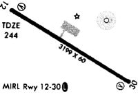
| Runways: | 12/30 |
| Longest Runway: | 12/30 is 3200 ft (975 m) long |
| Runways with an Instrument Approach: |
5F4 Airport Runway Details
| Runway 12/30 | 3200 ft x 60 ft (975 m x 18 m) | |
| Runway Length Source: | 3RD PARTY SURVEY as of 02/01/2022 | |
| Surface: | Asphalt - Good condition - No special surface treatment | |
| Runway Edge Lights: | Medium Intensity | |
Runway Weight Bearing Capacity (in thousands of pounds) |
||
| Single Wheel Landing Gear: | 12.0 | |
Runway 12 |
Runway 30 |
|
Elevation: |
244.0 | 228.2 |
Latitude: |
32-47-27.1071N | 32-47-10.0926N |
Longitude: |
093-00-28.9253W | 092-59-57.3138W |
|
Runway True Alignment: |
122 | 302 |
Glide Path Angle: |
0.0 degrees | 0.0 degrees |
Traffic Pattern: |
Left | Left |
Runway Markings Type: |
Basic | Basic |
Runway Markings Condition: |
Fair | Fair |
Object at End: |
TREES | TREES |
Object Height: |
63 | 66 |
Distance from End: |
356 | 461 |
Object Centerline Offset: |
183 ft. left of centerline | 283 ft. right of centerline |
REIL: |
Yes | Yes |
Services
Airframe Repair: |
Minor |
Powerplant Repair: |
Major |
Bottled Oxygen: |
None |
Bulk Oxygen: |
None |
Fuel Available: |
100LL, Jet A+ |
Landing Fees: |
No |
Parking: |
Tiedowns available |
Maps & Diagrams
5F4 Sectional
Flight Planning
at skyvector.com
at skyvector.com