Location
Latitude: |
43-48-48.6390N (43.813511) |
Longitude: |
115-08-06.2940W (-115.135082) |
Elevation: |
5500.0 feet MSL (1676 m MSL) |
Magnetic Variation: |
12.6 E (as of April 2024 from WMM2020 model) |
Time Zone: |
UTC -7.0 (Standard Time) UTC -6.0 (Daylight Savings Time) |
From City: |
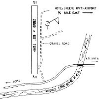
01 N.M. NW of Atlanta, Idaho |
Found On: |
Salt Lake City Chart |
FAA Region: |
ANM |
Contacts
Manager: |
Publicly owned: |
| IDAHO STATE-ITD/DIV OF AERONAUTICS BOX 7129 BOISE, ID 83707-1129 208-334-8775 |
IDAHO STATE-ITD/DIV OF AERONAUTICS BOX 7129 BOISE, ID 83707-1129 208-334-8775 |
Operations
Airport Status: |
Operational |
Facility Use: |
Public |
Type: |
Airport |
Activation Date: |
08/1982 |
Control tower: |
No |
Attendance (Months/Days/Hours): |
Months/Days/Hours Unattended |
Boundary ARTCC: |
ZLC (Salt Lake City) |
Responsible ARTCC: |
ZLC (Salt Lake City) |
Segmented Circle Indicator: |
Yes |
Traffic Pattern Altitude (MSL): |
6500 feet (1981 m) |
NOTAMs Facility: |
BOI |
NOTAM-D Service: |
Yes |
Based Aircraft
Annual Operations (as of 08/30/2023)
| Total Operations: | 450 | |
| Air Taxi: | 50 | 11.1% |
| GA Itinerant: | 400 | 88.9% |
Communications
| CTAF: | 122.900 |
Fixed Based Operators (FBOs) & Fuel
(Click on a business for detail)
Please help us keep this information up to date. This is a FREE SERVICE just like everything else on Airport Guide! If you see that a business needs to be added, modified, or deleted please fill out our Update Form.
To add, modify, or delete a business click here.
Please help us keep this information up to date. This is a FREE SERVICE just like everything else on Airport Guide! If you see that a business needs to be added, modified, or deleted please fill out our Update Form.
Area Code: 208 |
| Business Name | Frequency | Phone | Fuel Grade |
|---|
Flight Service Stations
| Primary | Alternate | |
| FSS on Field: | N | |
| FSS Name (ID): | Boise(BOI) | |
| Frequency: | ||
| Toll Free Phone: | 1-800-WX-BRIEF |
Instrument Procedures / Charts
Terminal Procedures are only available for airports in several countries with more being added all the time. If you are looking for a specific country's charts, please send an email to support(at)airportguide.com stating the country name. This will be used to prioritize the implementation.
Navigation Aids (Navaids) near 55H
| Dist (NM) | ID | Morse Code | Name | Type | Freq | True Hdg | Mag Hdg |
|---|---|---|---|---|---|---|---|
| 47.8 | STI | . . . _ . . | Sturgeon | NDB | 333 | 208 | 195 |
| 48.4 | HLE | . . . . . _ . . . | Hailey | NDB-DME | 220 | 126 | 114 |
| 48.5 | BOI | _ . . . _ _ _ . . | Boise | VORTAC | 113.30 | 251 | 238 |
| 49.5 | BOI | _ . . . _ _ _ . . | Boise | VOT | 116.70 | 252 | 239 |
| 52.8 | BO | _ . . . _ _ _ | Ustik | NDB | 359 | 256 | 243 |
| 56.5 | MUO | _ _ . . _ _ _ _ | Mountain Home | TACAN | 114.00 | 215 | 202 |
| 57.1 | LIA | . _ . . . . . _ | Liberator | VOR | 114.90 | 209 | 196 |
| 57.5 | HDG | . . . . _ . . _ _ . | Steelhead | NDB | 211 | 159 | 147 |
| 62.2 | MPA | _ _ . _ _ . . _ | Meridian | NDB | 238 | 258 | 245 |
| 73.4 | DNJ | _ . . _ . . _ _ _ | Donnelly | VOR-DME | 116.20 | 321 | 308 |
| 81.9 | ONO | _ _ _ _ . _ _ _ | Ontario | NDB | 305 | 279 | 266 |
| 84.9 | TWF | _ . _ _ . . _ . | Twin Falls | VORTAC | 113.10 | 160 | 148 |
| 85.3 | LKT | . _ . . _ . _ _ | Salmon | VOR-DME | 113.50 | 31 | 19 |
| 87.1 | TW | _ . _ _ | Strik | NDB | 389 | 156 | 144 |
| 92.5 | BYI | _ . . . _ . _ _ . . | Burley | VOR-DME | 114.10 | 142 | 130 |
Nearby Airports with Fuel
Notices to Airmen (NOTAMS)
Remarks
| A110-1 | RCMDED FOR USE BY MT PROFICIENT PILOTS USING PROPER, HIGH PER ACFT. ARPT IS LCTD IN MTUS AREA; HIGH TIMBERED RIDGES ALL ARND ARPT. LTD MNVRG AREA. LAND RWY 34, DEP RWY 16. APCH ARPT FM THE SE (VALLEY/CITY) MAKING RIGHT BASE AND FINAL FOR RWY 16. BE AWARE OF NEARBY PVT LAZY H RANCH ARPT (.7 MI TO THE EAST) AND CK FOR TFC FOR INCRD SITUATIONAL AWARENESS. RCMD PILOTS REVIEW THE INFO PERTINENT TO THE OPRNS AT THE LAZY H ARPT. |
| A110-2 | DEPART WITH A RIGHT TURNOUT DOWN BOISE RIVER. ANNOUNCE INTENTIONS ON 122.9. NO GO-AROUND DUE TO RISING TERRAIN AND TREES. |
| A110-3 | NO WINTER MAINT. |
| A110-4 | GND VEHICLE TFC HAS ACES TO ARPT & RWY. |
| A110-5 | NO FONE AVBL AT ARPT. TOWN OF ATLANTA IS APRXLY 1 MI WALKING DIST FM ARPT; SOME SVCS AVBL IN TOWN. |
| A110-6 | FOR CD CTC SALT LAKE ARTCC AT 801-320-2568. |
| A42-16 | RWY 16/34 EDGES & BOTH RWY ENDS THR MKD WITH W ROCKS. |
| A52-16 | 75 FT - 100 FT TREES AT 130 FT ON CNTRLN; +500 FT TIMBERED MT 1000 FT ON CNTRLN; 50 FT - 75 FT TREES AT 0 FT 100 FT LEFT. |
| A52-34 | +60 FT TREE 250 FT 125 FT LEFT; +1000 FT TIMBERED RIDGE AT 5000 FT ON CNTRLN. |
| A57-16 | RISING TRRN WITH 80 FT - 100 FT TALL TREES STARTING AT 50 FT PAST THE END OF RWY. |
| E111 | PROVIDED ARRIVAL/DEPARTURE PROCEDURES, INCLUDING RECOMMENDED COMMUNICATIONS PROCEDURES, AS SPECIFIED IN THE GREENE/COOKE AGREEMENT BE PUBLISHED IN THE IDAHO AIRPORT DIRECTORY; A WARNING NOTE ABOUT THE CLOSE PROXIMITY OF THE TWO AIRPORTS SHOULD BE PUBLISHED. |
Runways
Runway Summary
| Runways: | 16/34 |
| Longest Runway: | 16/34 is 2460 ft (750 m) long |
| Runways with an Instrument Approach: |
55H Airport Runway Details
| Runway 16/34 | 2460 ft x 75 ft (750 m x 23 m) | |
| Surface: | Turf/Dirt - Good condition - No special surface treatment | |
Runway 16 |
Runway 34 |
|
Glide Path Angle: |
0.0 degrees | 0.0 degrees |
Traffic Pattern: |
Right | |
Object at End: |
TREE | TREES |
Object Height: |
100 | 80 |
Distance from End: |
45 | 0 |
Object Centerline Offset: |
75 ft. right of centerline | 120 ft. left and right of centerline |
Services
Airframe Repair: |
Major |
Powerplant Repair: |
Major |
Bottled Oxygen: |
Low Pressure |
Bulk Oxygen: |
None |
Fuel Available: |
100LL, Jet A |
Landing Fees: |
No |
Parking: |
Tiedowns available |
Maps & Diagrams
55H Sectional
Flight Planning
at skyvector.com
at skyvector.com