Location
Latitude: |
42-12-24.5133N (42.206809) |
Longitude: |
088-19-22.7894W (-88.322997) |
Elevation: |
887.3 feet MSL (270 m MSL) |
Magnetic Variation: |
3.7 W (as of April 2024 from WMM2020 model) |
Time Zone: |
UTC -6.0 (Standard Time) UTC -5.0 (Daylight Savings Time) |
From City: |
38 N.M. NW of Chicago/Lake In The Hills, Illinois |
Found On: |
Chicago Chart |
FAA Region: |
AGL |
Contacts
Manager: |
Publicly owned: |
| JOELLE GARCIA 8397 PYOTT ROAD LAKE IN THE HILLS, IL 60156 815-479-7960 |
VILLAGE OF LAKE IN THE HILLS 600 HARVEST GATE LAKE IN THE HILLS, IL 60156 847-960-7400 |
Operations
Airport Status: |
Operational |
Facility Use: |
Public |
Type: |
Airport |
Activation Date: |
07/1958 |
Control tower: |
No |
Attendance (Months/Days/Hours): |
Months/Days/Hours MAY-OCT/MON-SUN/0800-1700 |
Boundary ARTCC: |
ZAU (Chicago) |
Responsible ARTCC: |
ZAU (Chicago) |
Lighting Schedule: |
SEE RMK |
Segmented Circle Indicator: |
No |
Traffic Pattern Altitude (MSL): |
1887 feet (575 m) |
NOTAMs Facility: |
IKK |
NOTAM-D Service: |
Yes |
International Airport of Entry: |
No |
Customs Landing Rights: |
No |
Military Landing Rights: |
No |
Civil/Military Joint Use: |
No |
Based Aircraft
| Single Engine: | 100 |
| Multi Engine: | 9 |
| Jet Engine: | 2 |
| GA Helicopters: | 3 |
Annual Operations (as of 07/31/2022)
| Total Operations: | 42000 | |
| GA Local: | 22000 | 52.4% |
| GA Itinerant: | 20000 | 47.6% |
Communications
| CTAF: | 123.050 |
| Unicom: | 123.050 |
| Approach: | CHICAGO 120.55 120.55 |
| Departure: | CHICAGO 120.55 120.55 |
Fixed Based Operators (FBOs) & Fuel
(Click on a business for detail)
Please help us keep this information up to date. This is a FREE SERVICE just like everything else on Airport Guide! If you see that a business needs to be added, modified, or deleted please fill out our Update Form.
To add, modify, or delete a business click here.
Please help us keep this information up to date. This is a FREE SERVICE just like everything else on Airport Guide! If you see that a business needs to be added, modified, or deleted please fill out our Update Form.
Area Code: 847 |
| Business Name | Frequency | Phone | Fuel Grade |
|---|---|---|---|
| Blue Skies Flying Services, Inc.
Update FBO info |
122.85 | 356-8121, 800-850-4397 | |
| Finefield Aviation
Update FBO info |
459-4858 | ||
| Lake in the Hills Aviation Group
Update FBO info |
Unicom 122.8 | 479-7960 | 100LL, Jet A |
| Meisner Aircraft, Inc.
Update FBO info |
455-1513 | ||
| Northern Illinois Flight Center
Website Update FBO info |
800-553-7371, 455-7707 | 100LL, Jet A | |
| Valley Air Service, Inc.
Website Update FBO info |
Unicom 122.8 | 468-7473 |
Flight Service Stations
| Primary | Alternate | |
| FSS on Field: | N | |
| FSS Name (ID): | Kankakee(IKK) | |
| Frequency: | ||
| Toll Free Phone: | 1-800-WX-BRIEF |
Instrument Procedures / Charts
FAA Terminal Procedures valid from 0901Z 03/21/24 to 0901Z 04/18/24.
There are various types of charts available for an airport. They are listed in the Page Type column. Here is a legend for those types:
APD - Airport Diagram
DP - Departure Procedure Charts
HOT - Hot Spots
IAP - Instrument Approach Procedure Charts
MIN - Minimums
STAR - Standard Terminal Arrival Charts
| Page Type | Page Name | Volume | Action Since Last Cycle |
|---|---|---|---|
| IAP | RNAV (GPS) RWY 08 | EC-3 | |
| IAP | RNAV (GPS) RWY 26 | EC-3 | |
| IAP | VOR RWY 26 | EC-3 | |
| MIN | TAKEOFF MINIMUMS | EC-3 |
Terminal Procedures are only available for airports in several countries with more being added all the time. If you are looking for a specific country's charts, please send an email to support(at)airportguide.com stating the country name. This will be used to prioritize the implementation.
Navigation Aids (Navaids) near 3CK
| Dist (NM) | ID | Morse Code | Name | Type | Freq | True Hdg | Mag Hdg |
|---|---|---|---|---|---|---|---|
| 16.5 | OBK | _ _ _ _ . . . _ . _ | Northbrook | VOR-DME | 113.00 | 86 | 90 |
| 19.0 | DPA | _ . . . _ _ . . _ | Dupage | VOR-DME | 108.40 | 183 | 187 |
| 19.5 | ME | _ _ . | Deana | NDB | 350 | 137 | 141 |
| 22.7 | GCO | _ _ . _ . _ . _ _ _ | Chicago | DME | 108.25 | 124 | 128 |
| 22.8 | ORD | _ _ _ . _ . _ . . | Chicago O'hare | VOR-DME | 113.90 | 125 | 129 |
| 24.9 | EN | . _ . | Codee | NDB | 389 | 31 | 35 |
| 27.8 | UG | . . _ _ _ . | Wauke | NDB | 379 | 56 | 60 |
| 29.0 | BUU | _ . . . . . _ . . _ | Burbun | DME | 114.5 | 1 | 5 |
| 29.2 | ENW | . _ . . _ _ | Kenosha | DME | 109.2 | 36 | 40 |
| 31.9 | LVV | . _ . . . . . _ . . . _ | Lake Lawn | NDB | 404 | 338 | 342 |
| 34.1 | RA | . _ . . _ | Paser | NDB | 206 | 33 | 37 |
| 34.9 | RF | . _ . . . _ . | Gilmy | NDB | 275 | 261 | 264 |
| 35.8 | MDW | _ _ _ . . . _ _ | Chicago Midway | VOT | 111.00 | 134 | 138 |
| 36.4 | HK | . . . . _ . _ | Ermin | NDB | 332 | 143 | 147 |
| 39.0 | RFD | . _ . . . _ . _ . . | Rockford | DME | 110.8 | 271 | 274 |
| 39.6 | JOT | . _ _ _ _ _ _ _ | Joliet | VOR-DME | 112.30 | 179 | 183 |
| 39.7 | MX | _ _ _ . . _ | Kedzi | NDB | 248 | 134 | 138 |
| 40.2 | JVL | . _ _ _ . . . _ . _ . . | Janesville | NDB | 375 | 307 | 310 |
| 40.2 | HRK | . . . . . _ . _ . _ | Horlick | DME | 114.05 | 33 | 37 |
| 40.6 | JVL | . _ _ _ . . . _ . _ . . | Janesville | VOR-DME | 114.30 | 301 | 304 |
Nearby Airports with Fuel
Notices to Airmen (NOTAMS)
Remarks
| A110-4 | FOR VFR WX ADVISORY 5 CLICKS CTAF. PHONE 815-444-1729 |
| A110-5 | FOR CD CTC CHICAGO APCH AT 847-289-0926. |
| A110-6 | PREF CALM WIND RWY 08 |
| A15 | EMAIL ADDRESS: MPERANICH@LITH.ORG (ALL LOWER CASE) |
| A16 | EXT: 2 |
| A57-08 | APCH RATIO 27:1 TO DSPLCD THR. |
| A81-APT | ACTVT LIRL RWY 08/26 - CTAF. |
Runways
Runway Summary
| Runways: | 08/26 |
| Longest Runway: | 08/26 is 3801 ft (1159 m) long |
| Runways with an Instrument Approach: |
3CK Airport Runway Details
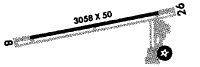
| Runway 08/26 | 3801 ft x 50 ft (1159 m x 15 m) | |
| Runway Length Source: | STATE as of 09/17/2010 | |
| Surface: | Asphalt - Good condition - No special surface treatment | |
| Runway Edge Lights: | Low Intensity | |
Runway Weight Bearing Capacity (in thousands of pounds) |
||
| Single Wheel Landing Gear: | 12.5 | |
| Dual Wheel Landing Gear: | 38.0 | |
Runway 08 |
Runway 26 |
|
Elevation: |
884.7 | 885.1 |
Latitude: |
42-12-21.1562N | 42-12-27.8703N |
Longitude: |
088-19-47.6375W | 088-18-57.9412W |
|
Runway True Alignment: |
080 | 260 |
Glide Path Angle: |
3.0 degrees | 3.0 degrees |
Traffic Pattern: |
Left | Left |
Runway Markings Type: |
Nonprecision Instrument | Nonprecision Instrument |
Runway Markings Condition: |
Good | Good |
Visual Glide Slope Indicators: |
2-Light PAPI On Left Side Of Runway | 2-Light PAPI On Right Side Of Runway |
REIL: |
No | |
Touchdown Lights: |
No | No |
Centerline Lights: |
No | No |
Threshold Crossing Height: |
20 | 20 |
Threshold Elevation: |
885.2 | 885.3 |
Displaced Threshold: |
360 | 382 |
Threshold Latitude: |
42-12-21.7997N | 42-12-27.1939N |
Threshold Longitude: |
088-19-42.9206W | 088-19-02.9425W |
Services
Airframe Repair: |
Major |
Powerplant Repair: |
Major |
Bottled Oxygen: |
None |
Bulk Oxygen: |
None |
Fuel Available: |
100LL, Jet A |
Landing Fees: |
No |
Parking: |
Hangars and tiedowns available |
Maps & Diagrams
3CK Sectional
Flight Planning
at skyvector.com
at skyvector.com