Location
Latitude: |
40-05-28.2050N (40.091168) |
Longitude: |
083-41-21.7300W (-83.689369) |
Elevation: |
1150.0 feet MSL (351 m MSL) |
Magnetic Variation: |
6.8 W (as of April 2024 from WMM2020 model) |
Time Zone: |
UTC -5.0 (Standard Time) UTC -4.0 (Daylight Savings Time) |
From City: |
03 N.M. ESE of Urbana, Ohio |
Found On: |
Detroit Chart |
FAA Region: |
AGL |
Contacts
Manager: |
Privately owned: |
| CHRISTOPHER COOK 8761 WILDLANE DR SOUTH CHARLESTON, OH 45368-7787 937-360-5308 |
CHRISTOPHER COOK 8761 WILDLANE DR SOUTH CHARLESTON, OH 45368-7787 937-360-5308 |
Operations
Airport Status: |
Operational |
Facility Use: |
Public |
Type: |
Airport |
Activation Date: |
11/1966 |
Control tower: |
No |
Attendance (Months/Days/Hours): |
Months/Days/Hours Unattended |
Boundary ARTCC: |
ZID (Indianapolis) |
Responsible ARTCC: |
ZID (Indianapolis) |
Segmented Circle Indicator: |
No |
Traffic Pattern Altitude (MSL): |
2150 feet (655 m) |
NOTAMs Facility: |
DAY |
NOTAM-D Service: |
Yes |
International Airport of Entry: |
No |
Customs Landing Rights: |
No |
Military Landing Rights: |
No |
Civil/Military Joint Use: |
No |
Based Aircraft
| Single Engine: | 1 |
Annual Operations (as of 08/15/2022)
| Total Operations: | 330 | |
| GA Local: | 200 | 60.6% |
| GA Itinerant: | 100 | 30.3% |
| Military Aircraft: | 30 | 9.1% |
Communications
| CTAF: | 123.000 |
| Unicom: | 123.000 |
Fixed Based Operators (FBOs) & Fuel
(Click on a business for detail)
Please help us keep this information up to date. This is a FREE SERVICE just like everything else on Airport Guide! If you see that a business needs to be added, modified, or deleted please fill out our Update Form.
To add, modify, or delete a business click here.
Please help us keep this information up to date. This is a FREE SERVICE just like everything else on Airport Guide! If you see that a business needs to be added, modified, or deleted please fill out our Update Form.
Area Code: 937 |
| Business Name | Frequency | Phone | Fuel Grade |
|---|
Flight Service Stations
| Primary | Alternate | |
| FSS on Field: | N | |
| FSS Name (ID): | Dayton(DAY) | |
| Frequency: | ||
| Toll Free Phone: | 1-800-WX-BRIEF |
Instrument Procedures / Charts
Terminal Procedures are only available for airports in several countries with more being added all the time. If you are looking for a specific country's charts, please send an email to support(at)airportguide.com stating the country name. This will be used to prioritize the implementation.
Navigation Aids (Navaids) near 38I
| Dist (NM) | ID | Morse Code | Name | Type | Freq | True Hdg | Mag Hdg |
|---|---|---|---|---|---|---|---|
| 13.7 | CCJ | _ . _ . _ . _ . . _ _ _ | Clark County | NDB | 341 | 197 | 204 |
| 16.7 | XSF | _ . . _ . . . . . _ . | Springfield | TACAN | 133.80 | 204 | 211 |
| 16.9 | SGH | . . . _ _ . . . . . | Springfield | DME | 113.2 | 205 | 212 |
| 20.1 | ROD | . _ . _ _ _ _ . . | Rosewood | VORTAC | 117.50 | 306 | 313 |
| 22.1 | RUV | . _ . . . _ . . . _ | Rushsylvania | NDB | 326 | 2 | 9 |
| 22.6 | OS | _ _ _ . . . | Fuler | NDB | 515 | 92 | 99 |
| 23.5 | FFO | . . _ . . . _ . _ _ _ | Patterson | TACAN | 109.20 | 225 | 232 |
| 26.8 | DAY | _ . . . _ _ . _ _ | Dayton J M Cox-Day | VOT | 111.00 | 244 | 251 |
| 27.6 | BU | _ . . . . . _ | Boutn | NDB | 230 | 126 | 133 |
| 30.7 | CHC | _ . _ . . . . . _ . _ . | Grens | NDB | 272 | 98 | 105 |
| 32.5 | CSS | _ . _ . . . . . . . | Court House | NDB | 414 | 154 | 161 |
| 32.8 | DQN | _ . . _ _ . _ _ . | Dayton | VOR-DME | 114.50 | 262 | 269 |
| 33.1 | AT | . _ _ | Bruny | NDB | 315 | 243 | 250 |
| 36.0 | IL | . . . _ . . | Airbo | NDB | 407 | 183 | 190 |
| 37.2 | DD | _ . . _ . . | Cobbs | NDB | 253 | 123 | 130 |
| 37.4 | CMH | _ . _ . _ _ . . . . | Port Columbus | VOT | 111.00 | 98 | 105 |
| 38.9 | LCK | . _ . . _ . _ . _ . _ | Rickenbacker | TACAN | 69X | 115 | 122 |
| 39.1 | AOH | . _ _ _ _ . . . . | Allen County | VOR | 108.40 | 341 | 348 |
| 40.0 | MXQ | _ _ _ . . _ _ _ . _ | Midwest | VOR-DME | 112.90 | 187 | 194 |
| 41.2 | LC | . _ . . _ . _ . | Pickl | NDB | 376 | 107 | 114 |
Nearby Airports with Fuel
Notices to Airmen (NOTAMS)
Remarks
| A110-1 | FOR CD CTC COLUMBUS APCH AT 614-338-8537. |
| A15 | ARPT PHYS LCTN: JUST NORTH OF 3138 E STATE ROUTE 29, URBANA OH 43078. |
| A42-09 | RWY OUTLINED WITH YELLOW TIRES; RWY END MKD WITH YELLOW CONC PANELS. |
| A42-27 | RWY OUTLINED WITH YELLOW TIRES; RWY END MKD WITH YELLOW CONC PANELS. |
| A75 | FOR LCTN OF TIEDOWN AREAS CALL AMGR. |
| E111 | VFR ONLY. |
Runways
Runway Summary
| Runways: | 09/27 |
| Longest Runway: | 09/27 is 2650 ft (808 m) long |
| Runways with an Instrument Approach: |
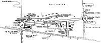
38I Airport Runway Details
| Runway 09/27 | 2650 ft x 75 ft (808 m x 23 m) | |
| Runway Length Source: | FAA OE/AAA as of 07/17/2001 | |
| Surface: | Turf - Good condition - No special surface treatment | |
Runway 09 |
Runway 27 |
|
Elevation: |
1150.0 | 1150.0 |
Latitude: |
40-05-26.9500N | 40-05-29.4600N |
Longitude: |
083-41-38.7000W | 083-41-04.7600W |
Glide Path Angle: |
0.0 degrees | 0.0 degrees |
Traffic Pattern: |
Left | Left |
Object at End: |
TREES | |
Object Height: |
60 | |
Distance from End: |
0 | |
Object Centerline Offset: |
80 ft. right of centerline | |
REIL: |
No | No |
Touchdown Lights: |
No | No |
Centerline Lights: |
No | No |
Services
Airframe Repair: |
Major |
Powerplant Repair: |
Major |
Bottled Oxygen: |
High Pressure / Low Pressure |
Bulk Oxygen: |
None |
Fuel Available: |
100LL, Jet A, Jet A+ |
Landing Fees: |
No |
Parking: |
Hangars and tiedowns available |
Maps & Diagrams
38I Sectional
Flight Planning
at skyvector.com
at skyvector.com