Location
Latitude: |
39-34-50.9000N (39.580806) |
Longitude: |
079-20-09.4000W (-79.335944) |
Elevation: |
2933.4 feet MSL (894 m MSL) |
Magnetic Variation: |
9.5 W (as of April 2024 from WMM2020 model) |
Time Zone: |
UTC -5.0 (Standard Time) UTC -4.0 (Daylight Savings Time) |
From City: |
13 N.M. NE of Oakland, Maryland |
Found On: |
Cincinnati Chart |
FAA Region: |
AEA |
Contacts
Manager: |
Publicly owned: |
| MR. MATTHEW KISNER 771 AIRPORT ROAD ACCIDENT, MD 21520 301-746-8599 |
BOARD OF CO COMMISSIONERS 313 EAST ALDER STREET, ROOM 105 OAKLAND, MD 21550 (301) 334-8970 |
Operations
Airport Status: |
Operational |
Facility Use: |
Public |
Type: |
Airport |
Activation Date: |
05/1962 |
Control tower: |
No |
Attendance (Months/Days/Hours): |
Months/Days/Hours ALL/ALL/0800-1800 |
Boundary ARTCC: |
ZOB (Cleveland) |
Responsible ARTCC: |
ZOB (Cleveland) |
Lighting Schedule: |
SEE RMK |
Segmented Circle Indicator: |
Yes |
Traffic Pattern Altitude (MSL): |
3933 feet (1199 m) |
NOTAMs Facility: |
EKN |
NOTAM-D Service: |
Yes |
International Airport of Entry: |
No |
Customs Landing Rights: |
No |
Military Landing Rights: |
Yes |
Civil/Military Joint Use: |
No |
Based Aircraft
| Single Engine: | 21 |
| Multi Engine: | 2 |
| GA Helicopters: | 3 |
Annual Operations (as of 07/17/2023)
| Total Operations: | 15875 | |
| Air Taxi: | 425 | 2.7% |
| GA Local: | 8550 | 53.9% |
| GA Itinerant: | 6850 | 43.1% |
| Military Aircraft: | 50 | 0.3% |
Communications
| CTAF: | 123.000 |
| Unicom: | 123.000 |
| Approach: | CLARKSBURG 119.425 119.425 CLEVELAND ARTCC |
| Departure: | CLARKSBURG 119.425 119.425 CLEVELAND ARTCC |
| AWOS-3: | 120.125 (301-746-8443) |
- APCH/DEP SVC PRVDD BY CLEVELAND ARTCC (ZOB) ON FREQS 124.4/327.1 (ALTOONA RCAG) WHEN CLARKSBURG APCH CTL CLSD.
Fixed Based Operators (FBOs) & Fuel
(Click on a business for detail)
Please help us keep this information up to date. This is a FREE SERVICE just like everything else on Airport Guide! If you see that a business needs to be added, modified, or deleted please fill out our Update Form.
To add, modify, or delete a business click here.
Please help us keep this information up to date. This is a FREE SERVICE just like everything else on Airport Guide! If you see that a business needs to be added, modified, or deleted please fill out our Update Form.
Area Code: 301 |
| Business Name | Frequency | Phone | Fuel Grade |
|---|---|---|---|
| Garrett County Airport
Website Update FBO info |
Unicom 123.0 | 301-746-8599 | 80, 100LL |

|
 Texaco |
100LL - 4.25 USD per gallon on 11/1/10 |
Pumps Requiring Line Service Cash discounts available |
|
|
Texaco |
Jet A - 4.15 USD per gallon on 11/1/10 |
Pumps Requiring Line Service Cash discounts available |
Flight Service Stations
| Primary | Alternate | |
| FSS on Field: | N | |
| FSS Name (ID): | Elkins(EKN) | |
| Frequency: | ||
| Toll Free Phone: | 1-800-WX-BRIEF |
Instrument Procedures / Charts
FAA Terminal Procedures valid from 0901Z 03/21/24 to 0901Z 04/18/24.
There are various types of charts available for an airport. They are listed in the Page Type column. Here is a legend for those types:
APD - Airport Diagram
DP - Departure Procedure Charts
HOT - Hot Spots
IAP - Instrument Approach Procedure Charts
MIN - Minimums
STAR - Standard Terminal Arrival Charts
| Page Type | Page Name | Volume | Action Since Last Cycle |
|---|---|---|---|
| IAP | RNAV (GPS) RWY 09 | NE-3 | |
| IAP | RNAV (GPS) RWY 27 | NE-3 | |
| IAP | VOR RWY 09 | NE-3 | |
| MIN | ALTERNATE MINIMUMS | NE-3 | |
| MIN | TAKEOFF MINIMUMS | NE-3 |
Terminal Procedures are only available for airports in several countries with more being added all the time. If you are looking for a specific country's charts, please send an email to support(at)airportguide.com stating the country name. This will be used to prioritize the implementation.
Navigation Aids (Navaids) near 2G4
| Dist (NM) | ID | Morse Code | Name | Type | Freq | True Hdg | Mag Hdg |
|---|---|---|---|---|---|---|---|
| 13.6 | GRV | _ _ . . _ . . . . _ | Grantsville | DME | 112.3 | 76 | 86 |
| 23.6 | IHD | . . . . . . _ . . | Indian Head | TACAN | 108.20 | 357 | 367 |
| 24.3 | MGW | _ _ _ _ . . _ _ | Morgantown | VOR-DME | 111.60 | 266 | 275 |
| 26.2 | VV | . . . _ . . . _ | Camor | NDB | 299 | 313 | 322 |
| 26.7 | ESL | . . . . . _ . . | Kessel | VOR-DME | 110.80 | 142 | 152 |
| 27.5 | CBE | _ . _ . _ . . . . | Cumberland | NDB | 317 | 81 | 91 |
| 35.9 | SYS | . . . _ . _ _ . . . | Stoystown | NDB | 209 | 32 | 42 |
| 47.5 | CKB | _ . _ . _ . _ _ . . . | Clarksburg | VOR-DME | 112.60 | 245 | 254 |
| 47.8 | BHU | _ . . . . . . . . . _ | Benje | NDB | 382 | 3 | 13 |
| 47.9 | RQY | . _ . _ _ . _ _ . _ _ | Randolph County | NDB | 284 | 210 | 219 |
| 49.8 | JST | . _ _ _ . . . _ | Johnstown | VOR-DME | 113.00 | 27 | 37 |
| 50.8 | MKP | _ _ _ . _ . _ _ . | Mc Keesport | NDB | 287 | 336 | 345 |
| 53.0 | AGC | . _ _ _ . _ . _ . | Allegheny | VOR-DME | 110.00 | 322 | 331 |
| 53.4 | EKN | . _ . _ _ . | Elkins | VORTAC | 114.20 | 221 | 230 |
| 63.9 | REC | . _ . . _ . _ . | Revloc | VOR-DME | 110.60 | 24 | 34 |
| 64.3 | INP | . . _ . . _ _ . | Indiana | NDB | 242 | 11 | 21 |
| 65.2 | AOO | . _ _ _ _ _ _ _ | Altoona | VOR | 108.80 | 46 | 56 |
| 66.4 | LUA | . _ . . . . _ . _ | Caverns | NDB | 245 | 142 | 152 |
| 67.2 | MMJ | _ _ _ _ . _ _ _ | Montour | DME | 112 | 324 | 333 |
| 67.3 | THS | _ . . . . . . . | St Thomas | VORTAC | 115.00 | 71 | 81 |
Nearby Airports with Fuel
Notices to Airmen (NOTAMS)
Remarks
| A110*G | THIS AIRPORT HAS BEEN SURVEYED BY THE NATIONAL GEODETIC SURVEY. |
| A110-4 | WILDLIFE ON AND INVOF ARPT. |
| A110-5 | FOR CD CTC CLARKSBURG APCH AT 304-842-2011, WHEN APCH CLSD CTC CLEVELAND ARTCC AT 440-774-0226. |
| A16 | MGR EMERG NR (301) 616-7467. |
| A17 | UNATNDD CHRISTMAS AND NEW YEARS DAY. |
| A70-FUEL-10 | 0LL 24 HR SELF SERVE 100LL AND JET-A, W/PRIST AVBL WITH CREDIT CARD. |
| A81-APT | ACTVT REIL RWY 09 & 27; PAPI RWY 09 & 27; MIRL RWY 09/27 - CTAF. |
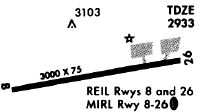
Runways
Runway Summary
| Runways: | 09/27 |
| Longest Runway: | 09/27 is 5000 ft (1524 m) long |
| Runways with an Instrument Approach: |
2G4 Airport Runway Details
| Runway 09/27 | 5000 ft x 75 ft (1524 m x 23 m) | |
| Surface: | Asphalt - Good condition - Saw-cut or plastic grooved | |
| Runway Edge Lights: | Medium Intensity | |
Runway 09 |
Runway 27 |
|
Elevation: |
2933.1 | 2876.9 |
Latitude: |
39-34-46.1867N | 39-34-55.6664N |
Longitude: |
079-20-40.7018W | 079-19-38.0403W |
|
Runway True Alignment: |
079 | 259 |
Glide Path Angle: |
3.0 degrees | 3.0 degrees |
Traffic Pattern: |
Left | Left |
Runway Markings Type: |
Nonprecision Instrument | Nonprecision Instrument |
Runway Markings Condition: |
Good | Good |
Visual Glide Slope Indicators: |
4-Light PAPI On Left Side Of Runway | 4-Light PAPI On Right Side Of Runway |
REIL: |
Yes | Yes |
Threshold Crossing Height: |
44 | 45 |
Services
Airframe Repair: |
None |
Powerplant Repair: |
None |
Fuel Available: |
100LL |
Landing Fees: |
No |
Parking: |
Tiedowns available |
Maps & Diagrams
2G4 Sectional
Flight Planning
at skyvector.com
at skyvector.com