Location
Latitude: |
40-02-46.3195N (40.0462) |
Longitude: |
098-03-40.5196W (-98.061255) |
Elevation: |
1691.5 feet MSL (516 m MSL) |
Magnetic Variation: |
3.6 E (as of April 2024 from WMM2020 model) |
Time Zone: |
UTC -6.0 (Standard Time) UTC -5.0 (Daylight Savings Time) |
From City: |
02 N.M. N of Superior, Nebraska |
Found On: |
Omaha Chart |
FAA Region: |
ACE |
Contacts
Manager: |
Publicly owned: |
| LUKE MEYERS 422 HIGHWAY 14 SUPERIOR, NE 68978-9503 402-879-3006 |
SUPERIOR AIRPORT AUTHORITY 422 HIGHWAY 14 SUPERIOR, NE 68978-1021 402-879-3006 |
Operations
Airport Status: |
Operational |
Facility Use: |
Public |
Type: |
Airport |
Activation Date: |
01/1947 |
Control tower: |
No |
Attendance (Months/Days/Hours): |
Months/Days/Hours ALL/MON-FRI/0800-1700 |
Boundary ARTCC: |
ZMP (Minneapolis) |
Responsible ARTCC: |
ZMP (Minneapolis) |
Lighting Schedule: |
SEE RMK |
Segmented Circle Indicator: |
Yes |
Traffic Pattern Altitude (MSL): |
2692 feet (821 m) |
NOTAMs Facility: |
OLU |
NOTAM-D Service: |
Yes |
International Airport of Entry: |
No |
Customs Landing Rights: |
No |
Military Landing Rights: |
Yes |
Civil/Military Joint Use: |
No |
Based Aircraft
| Single Engine: | 12 |
Annual Operations (as of 07/07/2021)
| Total Operations: | 12500 | |
| GA Local: | 11800 | 94.4% |
| GA Itinerant: | 700 | 5.6% |
Communications
| CTAF: | 123.000 |
| Unicom: | 123.000 |
- APCH/DEP SVC PRVDD BY MINNEAPOLIS ARTCC ON FREQS 119.4/278.8 (HASTINGS RCAG).
Fixed Based Operators (FBOs) & Fuel
(Click on a business for detail)
Please help us keep this information up to date. This is a FREE SERVICE just like everything else on Airport Guide! If you see that a business needs to be added, modified, or deleted please fill out our Update Form.
To add, modify, or delete a business click here.
Please help us keep this information up to date. This is a FREE SERVICE just like everything else on Airport Guide! If you see that a business needs to be added, modified, or deleted please fill out our Update Form.
Area Code: 402 |
| Business Name | Frequency | Phone | Fuel Grade |
|---|---|---|---|
| Butler Air Service
Update FBO info |
Unicom 123.0 | 879-3006, -3348 | 100LL |
Flight Service Stations
| Primary | Alternate | |
| FSS on Field: | N | |
| FSS Name (ID): | Columbus(OLU) | |
| Frequency: | ||
| Toll Free Phone: | 1-800-WX-BRIEF |
Instrument Procedures / Charts
FAA Terminal Procedures valid from 0901Z 03/21/24 to 0901Z 04/18/24.
There are various types of charts available for an airport. They are listed in the Page Type column. Here is a legend for those types:
APD - Airport Diagram
DP - Departure Procedure Charts
HOT - Hot Spots
IAP - Instrument Approach Procedure Charts
MIN - Minimums
STAR - Standard Terminal Arrival Charts
| Page Type | Page Name | Volume | Action Since Last Cycle |
|---|---|---|---|
| IAP | RNAV (GPS) RWY 14 | NC-2 | Changed |
| IAP | RNAV (GPS) RWY 32 | NC-2 | |
| MIN | TAKEOFF MINIMUMS | NC-2 |
Terminal Procedures are only available for airports in several countries with more being added all the time. If you are looking for a specific country's charts, please send an email to support(at)airportguide.com stating the country name. This will be used to prioritize the implementation.
Navigation Aids (Navaids) near 12K
| Dist (NM) | ID | Morse Code | Name | Type | Freq | True Hdg | Mag Hdg |
|---|---|---|---|---|---|---|---|
| 17.0 | TKO | _ _ . _ _ _ _ | Mankato | VORTAC | 109.80 | 212 | 208 |
| 22.6 | HJH | . . . . . _ _ _ . . . . | Hebron | NDB | 323 | 73 | 70 |
| 23.2 | RPB | . _ . . _ _ . _ . . . | Republican | NDB | 414 | 126 | 123 |
| 35.1 | CNK | _ . _ . _ . _ . _ | Concordia | NDB | 335 | 147 | 144 |
| 37.5 | HSI | . . . . . . . . . | Hastings | VOR-DME | 108.80 | 333 | 329 |
| 39.7 | FMZ | . . _ . _ _ _ _ . . | Beklof | NDB | 392 | 34 | 31 |
| 41.8 | FBY | . . _ . _ . . . _ . _ _ | Fairbury | NDB | 293 | 78 | 75 |
| 42.9 | PSS | . _ _ . . . . . . . | Prosser | NDB | 338 | 333 | 329 |
| 50.9 | GR | _ _ . . _ . | Sancy | NDB | 380 | 346 | 342 |
| 55.0 | JYR | . _ _ _ _ . _ _ . _ . | York | NDB | 257 | 21 | 18 |
| 56.2 | EA | . . _ | Anoke | NDB | 422 | 308 | 304 |
| 57.4 | GRI | _ _ . . _ . . . | Grand Island | VOR-DME | 112.00 | 348 | 344 |
| 57.6 | CYW | _ . _ . _ . _ _ . _ _ | Clay Center | NDB | 362 | 133 | 130 |
| 59.3 | EAR | . . _ . _ . | Kearney | VOR | 111.20 | 313 | 309 |
| 60.1 | PHG | . _ _ . . . . . _ _ . | Phillipsburg | NDB | 368 | 250 | 246 |
| 61.8 | BIE | _ . . . . . . | Beatrice | VOR | 110.60 | 75 | 72 |
| 65.3 | SWT | . . . . _ _ _ | Seward | NDB | 269 | 41 | 38 |
| 70.3 | SLN | . . . . _ . . _ . | Salina | VORTAC | 117.10 | 163 | 160 |
| 72.7 | LN | . _ . . _ . | Potts | NDB | 385 | 54 | 51 |
| 80.0 | LNK | . _ . . _ . _ . _ | Lincoln | VORTAC | 116.10 | 48 | 45 |
Nearby Airports with Fuel
Notices to Airmen (NOTAMS)
Remarks
| A11 | LANCE TEACHWORTH, CHAIRMAN. |
| A110-1 | FOR CD CTC MINNEAPOLIS ARTCC AT 651-463-5588. |
| A17 | FOR ATTENDANT AFTER HOURS CALL 402-879-5852 OR 402-879-1383. |
| A75 | CALL 402-879-3006 TO ARNG HNGR STORAGE. |
| A81-APT | ACTVT MIRL, PAPI & REIL RY 14/32 - CTAF. |
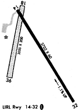
Runways
Runway Summary
| Runways: | 14/32 18/36 |
| Longest Runway: | 14/32 is 4301 ft (1311 m) long |
| Runways with an Instrument Approach: |
12K Airport Runway Details
| Runway 14/32 | 4301 ft x 75 ft (1311 m x 23 m) | |
| Runway Length Source: | 3RD PARTY SURVEY as of 09/27/2010 | |
| Surface: | Concrete - Excellent condition - No special surface treatment | |
| Runway Edge Lights: | Medium Intensity | |
Runway 14 |
Runway 32 |
|
Elevation: |
1691.5 | 1639.4 |
Latitude: |
40-03-01.8511N | 40-02-27.0499N |
Longitude: |
098-03-50.0093W | 098-03-18.2831W |
|
Runway True Alignment: |
145 | 325 |
Glide Path Angle: |
3.0 degrees | 3.0 degrees |
Traffic Pattern: |
Left | Left |
Runway Markings Type: |
Nonprecision Instrument | Nonprecision Instrument |
Runway Markings Condition: |
Good | Good |
Object at End: |
ROAD | TREE |
Object Height: |
21 | 27 |
Distance from End: |
943 | 983 |
Object Centerline Offset: |
327 ft. right of centerline | 0 ft. left and right of centerline |
Visual Glide Slope Indicators: |
2-Light PAPI On Left Side Of Runway | 2-Light PAPI On Left Side Of Runway |
REIL: |
Yes | Yes |
Threshold Crossing Height: |
40 | 40 |
| Runway 18/36 | 2999 ft x 200 ft (914 m x 61 m) | |
| Runway Length Source: | 3RD PARTY SURVEY as of 09/27/2010 | |
| Surface: | Concrete - Excellent condition - No special surface treatment | |
Runway 18 |
Runway 36 |
|
Elevation: |
1682.0 | 1691.0 |
Latitude: |
40-03-03.5700N | 40-02-34.4300N |
Longitude: |
098-03-46.1600W | 098-03-53.1600W |
|
Runway True Alignment: |
190 | 010 |
Glide Path Angle: |
0.0 degrees | 0.0 degrees |
Traffic Pattern: |
Left | Left |
Object at End: |
TREE | TREE |
Object Height: |
47 | 55 |
Distance from End: |
1047 | 1709 |
Object Centerline Offset: |
327 ft. right of centerline | 0 ft. left and right of centerline |
Services
Airframe Repair: |
Major |
Powerplant Repair: |
Major |
Bottled Oxygen: |
None |
Bulk Oxygen: |
None |
Fuel Available: |
100LL |
Landing Fees: |
No |
Parking: |
Hangars and tiedowns available |
Maps & Diagrams
12K Sectional
Flight Planning
at skyvector.com
at skyvector.com