Location
Latitude: |
30-41-09.4800N (30.685967) |
Longitude: |
081-54-22.8350W (-81.906343) |
Elevation: |
59.0 feet MSL (18 m MSL) |
Magnetic Variation: |
6.7 W (as of April 2024 from WMM2020 model) |
Time Zone: |
UTC -5.0 (Standard Time) UTC -4.0 (Daylight Savings Time) |
From City: |
01 N.M. E of Hilliard, Florida |
Found On: |
Jacksonville Chart |
FAA Region: |
ASO |
Contacts
Manager: |
Publicly owned: |
| MICHAEL SWAIN 37792 EASTWOOD RD HILLIARD, FL 32406 904-675-9120 |
TOWN OF HILLIARD PO BOX 249 HILLIARD, FL 32046 904-845-3555 |
Operations
Airport Status: |
Operational |
Facility Use: |
Public |
Type: |
Airport |
Activation Date: |
12/1969 |
Control tower: |
No |
Attendance (Months/Days/Hours): |
Months/Days/Hours Unattended |
Boundary ARTCC: |
ZJX (Jacksonville) |
Responsible ARTCC: |
ZJX (Jacksonville) |
Lighting Schedule: |
SEE RMK |
Segmented Circle Indicator: |
Yes |
Traffic Pattern Altitude (MSL): |
1059 feet (323 m) |
NOTAMs Facility: |
GNV |
NOTAM-D Service: |
Yes |
International Airport of Entry: |
No |
Customs Landing Rights: |
No |
Civil/Military Joint Use: |
No |
Based Aircraft
| Single Engine: | 25 |
Annual Operations (as of 02/06/2018)
| Total Operations: | 5000 | |
| GA Local: | 3120 | 62.4% |
| GA Itinerant: | 1880 | 37.6% |
Communications
| CTAF: | 122.900 |
Fixed Based Operators (FBOs) & Fuel
(Click on a business for detail)
Please help us keep this information up to date. This is a FREE SERVICE just like everything else on Airport Guide! If you see that a business needs to be added, modified, or deleted please fill out our Update Form.
To add, modify, or delete a business click here.
Please help us keep this information up to date. This is a FREE SERVICE just like everything else on Airport Guide! If you see that a business needs to be added, modified, or deleted please fill out our Update Form.
Area Code: 904 |
| Business Name | Frequency | Phone | Fuel Grade |
|---|---|---|---|
| Hilliard Aviation, Inc.
Update FBO info |
Unicom 122.9 | 845-3446 |
Flight Service Stations
| Primary | Alternate | |
| FSS on Field: | N | |
| FSS Name (ID): | Gainesville(GNV) | |
| Frequency: | ||
| Toll Free Phone: | 1-800-WX-BRIEF |
Instrument Procedures / Charts
Terminal Procedures are only available for airports in several countries with more being added all the time. If you are looking for a specific country's charts, please send an email to support(at)airportguide.com stating the country name. This will be used to prioritize the implementation.
Navigation Aids (Navaids) near 01J
| Dist (NM) | ID | Morse Code | Name | Type | Freq | True Hdg | Mag Hdg |
|---|---|---|---|---|---|---|---|
| 14.3 | JA | . _ _ _ . _ | Dinns | NDB | 344 | 157 | 164 |
| 16.0 | JAX | . _ _ _ . _ _ . . _ | Jacksonville Intl | VOT | 111.00 | 136 | 143 |
| 22.0 | EYA | . _ . _ _ . _ | Eastport | NDB | 357 | 135 | 142 |
| 28.4 | VQQ | . . . _ _ _ . _ _ _ . _ | Cecil | VOR | 117.90 | 178 | 185 |
| 29.2 | CRG | _ . _ . . _ . _ _ . | Craig | VORTAC | 114.50 | 135 | 142 |
| 29.6 | NIP | _ . . . . _ _ . | Jacksonville | TACAN | 108.20 | 156 | 163 |
| 30.7 | NRB | _ . . _ . _ . . . | Mayport | TACAN | 111.40 | 125 | 132 |
| 32.3 | SSI | . . . . . . . . | Brunswick | VORTAC | 109.80 | 47 | 54 |
| 35.1 | TAY | _ . _ _ . _ _ | Taylor | VORTAC | 112.90 | 252 | 259 |
| 42.1 | BQK | _ . . . _ _ . _ _ . _ | Brunswick | VOT | 111.00 | 33 | 40 |
| 45.0 | RYD | . _ . _ . _ _ _ . . | Reynolds | NDB | 338 | 163 | 170 |
| 46.0 | LCQ | . _ . . _ . _ . _ _ . _ | Lake City | NDB | 204 | 229 | 236 |
| 46.0 | AY | . _ _ . _ _ | Wiket | NDB | 219 | 326 | 333 |
| 48.4 | AYS | . _ _ . _ _ . . . | Waycross | VORTAC | 110.20 | 316 | 323 |
| 49.8 | HOE | . . . . _ _ _ . | Homerville | NDB | 209 | 296 | 303 |
| 52.0 | JES | . _ _ _ . . . . | Slover | NDB | 340 | 1 | 8 |
| 53.0 | SGJ | . . . _ _ . . _ _ _ | St Augustine | VOR-DME | 109.40 | 145 | 152 |
| 59.7 | AMG | . _ _ _ _ _ . | Alma | VORTAC | 115.10 | 328 | 335 |
| 62.1 | IAK | . . . _ _ . _ | Palatka | NDB | 243 | 175 | 182 |
| 62.5 | GN | _ _ . _ . | Wynds | NDB | 269 | 192 | 199 |
Nearby Airports with Fuel
Notices to Airmen (NOTAMS)
Remarks
| A11 | CONTACT PERSON: LISA PURVIS, 904-845-3555 |
| A110-3 | FOR CD CTC JACKSONVILLE APCH AT 904-741-0284. |
| A110-4 | UNLGTD OBSTNS PRSNT IN THE APCH OF RWY 18 DUE TO TREES 420 FT BFR THE APCH END OF THE RWY. |
| A14 | AIRPORT PHYSICAL ADDRESS: 37776 EAST WOOD ROAD |
| A30A-18 | TREES 420 FT BFR THE APCH END OF THE RWY. |
| A30A-36 | TREES 270-620 FT BFR THE APCH END OF THE RWY. |
| A33-18/36 | SOFT & WET JUN-AUG & AFT RAINS. |
| A43-18 | PAPI 18 UNUSBL BYD 8 DEG RIGHT OF CRS. |
| A43-36 | PAPI 36 UNUSBL BYD 5 DEG LEFT OF CRS. |
| A57-18 | APCH RATIO 16:1 TO DISP THLD DUE TO 59 FT TREES 540 FT FM END OF RWY 125 FT L OF CNTRLN. |
| A57-36 | APCH RATIO 20:1 TO DISP THLD. |
| A81-APT | ACTVT REIL RWY 18 & 36; PAPI RWY 18 & 36 ; MIRL RWY 18/36 - CTAF. |
| E111 | VFR OPN ONLY. |
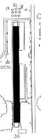
Runways
Runway Summary
| Runways: | 18/36 |
| Longest Runway: | 18/36 is 3600 ft (1097 m) long |
| Runways with an Instrument Approach: |
01J Airport Runway Details
| Runway 18/36 | 3600 ft x 125 ft (1097 m x 38 m) | |
| Runway Length Source: | OWNER as of 11/18/2012 | |
| Surface: | Turf - Fair condition - No special surface treatment | |
| Runway Edge Lights: | Medium Intensity | |
Runway 18 |
Runway 36 |
|
Elevation: |
54.1 | 51.3 |
Latitude: |
30-41-27.2900N | 30-40-51.6700N |
Longitude: |
081-54-23.2200W | 081-54-22.4500W |
Glide Path Angle: |
3.0 degrees | 3.0 degrees |
Traffic Pattern: |
Left | |
Runway Markings Type: |
Nonstandard (other than numbers only) | Nonstandard (other than numbers only) |
Runway Markings Condition: |
Good | Good |
Object at End: |
FENCE | TREES |
Object Height: |
7 | 54 |
Object Marked/Lighted?: |
Marked | |
Distance from End: |
32 | 270 |
Object Centerline Offset: |
0 ft. left and right of centerline | 90 ft. right of centerline |
Visual Glide Slope Indicators: |
2-Light PAPI On Right Side Of Runway | 2-Light PAPI On Left Side Of Runway |
REIL: |
Yes | Yes |
Threshold Crossing Height: |
32 | 43 |
Threshold Elevation: |
57.5 | 53.6 |
Displaced Threshold: |
400 | 730 |
Threshold Latitude: |
30-41-23.3400N | 30-40-58.9000N |
Threshold Longitude: |
081-54-23.1400W | 081-54-22.6100W |
Services
Airframe Repair: |
None |
Powerplant Repair: |
None |
Bottled Oxygen: |
None |
Bulk Oxygen: |
None |
Fuel Available: |
100LL |
Landing Fees: |
No |
Parking: |
Tiedowns available |
Maps & Diagrams
01J Sectional
Flight Planning
at skyvector.com
at skyvector.com