Location
Latitude: |
62-03-53.2390N (62.064789) |
Longitude: |
146-27-37.8790W (-146.460522) |
Elevation: |
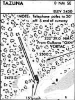
2450.0 feet MSL (747 m MSL) |
Magnetic Variation: |
16 E (as of April 2024 from WMM2020 model) |
Time Zone: |
UTC -9.0 (Standard Time) UTC -8.0 (Daylight Savings Time) |
From City: |
00 N.M. SE of Tazlina, Alaska |
Found On: |
Anchorage Chart |
FAA Region: |
AAL |
Contacts
Manager: |
Publicly owned: |
| CHAD HELLER PO BOX 7, PO BOX 7 GLENNALLEN, AK 99588 907-822-3222 |
ALASKA DOT&PF NORTHERN REGION NORTHERN REGION, 2301 PEGER RD FAIRBANKS, AK 99701 907-451-2200 |
Operations
Airport Status: |
Operational |
Facility Use: |
Public |
Type: |
Airport |
Activation Date: |
09/1950 |
Control tower: |
No |
Attendance (Months/Days/Hours): |
Months/Days/Hours Unattended |
Boundary ARTCC: |
ZAN (Anchorage) |
Responsible ARTCC: |
ZAN (Anchorage) |
Segmented Circle Indicator: |
No |
Traffic Pattern Altitude (MSL): |
3450 feet (1052 m) |
NOTAMs Facility: |
ENA |
NOTAM-D Service: |
Yes |
International Airport of Entry: |
No |
Customs Landing Rights: |
No |
Military Landing Rights: |
Yes |
Civil/Military Joint Use: |
No |
Based Aircraft
| Single Engine: | 1 |
Annual Operations (as of 12/31/2019)
| Total Operations: | 200 | |
| Air Taxi: | 30 | 15.0% |
| GA Local: | 100 | 50.0% |
| GA Itinerant: | 70 | 35.0% |
Communications
| CTAF: | 122.900 |
Fixed Based Operators (FBOs) & Fuel
(Click on a business for detail)
Please help us keep this information up to date. This is a FREE SERVICE just like everything else on Airport Guide! If you see that a business needs to be added, modified, or deleted please fill out our Update Form.
To add, modify, or delete a business click here.
Please help us keep this information up to date. This is a FREE SERVICE just like everything else on Airport Guide! If you see that a business needs to be added, modified, or deleted please fill out our Update Form.
Area Code: 822 |
| Business Name | Frequency | Phone | Fuel Grade |
|---|
Flight Service Stations
| Primary | Alternate | |
| FSS on Field: | N | |
| FSS Name (ID): | Kenai(ENA) | |
| Frequency: | ||
| Toll Free Phone: | 1-866-864-1737 |
Instrument Procedures / Charts
Terminal Procedures are only available for airports in several countries with more being added all the time. If you are looking for a specific country's charts, please send an email to support(at)airportguide.com stating the country name. This will be used to prioritize the implementation.
Navigation Aids (Navaids) near Z14
| Dist (NM) | ID | Morse Code | Name | Type | Freq | True Hdg | Mag Hdg |
|---|---|---|---|---|---|---|---|
| 28.9 | GLA | _ _ . . _ . . . _ | Glennallen | NDB | 248 | 73 | 57 |
| 28.9 | GKN | _ _ . _ . _ _ . | Gulkana | VOR-DME | 115.60 | 78 | 62 |
| 56.5 | MNL | _ _ _ . . _ . . | Mineral Creek | NDB | 524 | 176 | 160 |
| 95.1 | JOH | . _ _ _ _ _ _ . . . . | Johnstone Point | VOR-DME | 116.70 | 182 | 166 |
| 95.2 | ALJ | . _ . _ . . . _ _ _ | Orca Bay | NDB | 233 | 182 | 166 |
| 98.2 | GCR | _ _ . _ . _ . . _ . | Glacier River | NDB | 404 | 162 | 146 |
Nearby Airports with Fuel
| Dist (NM) | Name (Airport IDs) | True Hdg | Mag Hdg | Fuel Grade |
|---|---|---|---|---|
| 79.6 | Warren 'Bud' Woods Palmer Municipal Airport (PAQ PAAQ PAQ) |
250 | 235 | 100LL, Jet A-1 |
| 88.3 | Wasilla Lake Seaplane Base (5L6) |
252 | 237 | 100LL |
| 92.1 | Wasilla Airport (WWA PAWS IYS) |
252 | 237 | 100LL, Jet A |
| 93.7 | Cordova Municipal Airport (CKU CKU) |
166 | 150 | 100LL |
| 94.9 | Birchwood Airport (PABV BCV) |
247 | 232 | 100LL |
Notices to Airmen (NOTAMS)
Remarks
| A110-1 | NO WINTER MAINT. |
| A110-5 | RY NOT MAINTAINED & CONDITION NOT MONITORED, RECOMMEND VISUAL INSPECTION PRIOR TO LANDING. |
| A42-13 | RYS 13 & 31 THLDS & RY EDGES MKD WITH REFLECTIVE ORANGE CONES. |
Runways
Runway Summary
| Runways: | 13/31 |
| Longest Runway: | 13/31 is 1200 ft (366 m) long |
| Runways with an Instrument Approach: |
Z14 Airport Runway Details
| Runway 13/31 | 1200 ft x 40 ft (366 m x 12 m) | |
| Runway Length Source: | STATE as of 12/03/2010 | |
| Surface: | Gravel - Good condition - No special surface treatment | |
Runway 13 |
Runway 31 |
|
Glide Path Angle: |
0.0 degrees | 0.0 degrees |
Traffic Pattern: |
Left | Left |
Runway Markings Type: |
Nonstandard (other than numbers only) | Nonstandard (other than numbers only) |
Object at End: |
TREES | BRUSH |
Object Height: |
45 | 11 |
Distance from End: |
0 | 0 |
Object Centerline Offset: |
112 ft. right of centerline | 99 ft. right of centerline |
Services
Airframe Repair: |
Major |
Powerplant Repair: |
Major |
Fuel Available: |
100LL |
Parking: |
Hangars and tiedowns available |
Maps & Diagrams
Z14 Sectional
Flight Planning
at skyvector.com
at skyvector.com