Location
Latitude: |
44-23-07.1090N (44.385308) |
Longitude: |
074-12-22.2530W (-74.206181) |
Elevation: |
1662.6 feet MSL (507 m MSL) |
Magnetic Variation: |
13.3 W (as of April 2024 from WMM2020 model) |
Time Zone: |
UTC -5.0 (Standard Time) UTC -4.0 (Daylight Savings Time) |
From City: |
04 N.M. NW of Saranac Lake, New York |
Found On: |
Montreal Chart |
FAA Region: |
AEA |
Contacts
Manager: |
Publicly owned: |
| COREY HURWITCH 96 AIRPORT ROAD SARANAC LAKE, NY 12983 518-891-4600 |
TOWN OF HARRIETSTOWN 39 MAIN STREET SARANAC LAKE, NY 12983 518-891-1470 |
Operations
Airport Status: |
Operational |
Facility Use: |
Public |
Type: |
Airport |
Activation Date: |
12/1942 |
Control tower: |
No |
Attendance (Months/Days/Hours): |
Months/Days/Hours MAY-OCT/ALL/0600-2100 |
Boundary ARTCC: |
ZBW (Boston) |
Responsible ARTCC: |
ZBW (Boston) |
Lighting Schedule: |
SEE RMK |
Traffic Pattern Altitude (MSL): |
2663 feet (812 m) |
NOTAMs Facility: |
SLK |
NOTAM-D Service: |
Yes |
International Airport of Entry: |
No |
Customs Landing Rights: |
Yes |
Military Landing Rights: |
Yes |
Civil/Military Joint Use: |
No |
Aircraft Rescue and Firefighting: |
Class IV ARFF Index: A Air Carrier Service: Scheduled Certification Date: 11/2005 |
Based Aircraft
| Single Engine: | 10 |
| Multi Engine: | 4 |
| GA Helicopters: | 2 |
Annual Operations (as of 06/30/2023)
| Total Operations: | 6116 | |
| Air Taxi: | 1614 | 26.4% |
| GA Local: | 870 | 14.2% |
| GA Itinerant: | 3480 | 56.9% |
| Military Aircraft: | 152 | 2.5% |
Communications
| CTAF: | 123.000 |
| Unicom: | 123.000 |
| ASOS: | 124.175 (518-891-6696) |
- APCH/DEP SVC PRVDD BY BOSTON ARTCC ON FREQS 120.35/342.25 (ST. ALBANS RCAG).
Fixed Based Operators (FBOs) & Fuel
(Click on a business for detail)
Please help us keep this information up to date. This is a FREE SERVICE just like everything else on Airport Guide! If you see that a business needs to be added, modified, or deleted please fill out our Update Form.
To add, modify, or delete a business click here.
Please help us keep this information up to date. This is a FREE SERVICE just like everything else on Airport Guide! If you see that a business needs to be added, modified, or deleted please fill out our Update Form.
Area Code: 518 |
| Business Name | Frequency | Phone | Fuel Grade |
|---|---|---|---|
| Adirondack Regional Airport
Update FBO info |
Unicom 123.00 | 891-4600 | 100LL, Jet A |

|
Air Bp | 100LL - 2.42 USD per gallon on 9/23/01 |
Trucks |
|
|
Air Bp | Jet A - 2.54 USD per gallon on 9/23/01 |
Trucks Discounts over 500 gallons |
| North Country Aviation, Inc.
Update FBO info |
Unicom 123.0 | 891-1262 | |
| Olympic Finishers
Update FBO info |
891-5563 | Mogas |
Flight Service Stations
| Primary | Alternate | |
| FSS on Field: | N | |
| FSS Name (ID): | Burlington(BTV) | |
| Frequency: | ||
| Toll Free Phone: | 1-800-WX-BRIEF |
Instrument Procedures / Charts
FAA Terminal Procedures valid from 0901Z 03/21/24 to 0901Z 04/18/24.
There are various types of charts available for an airport. They are listed in the Page Type column. Here is a legend for those types:
APD - Airport Diagram
DP - Departure Procedure Charts
HOT - Hot Spots
IAP - Instrument Approach Procedure Charts
MIN - Minimums
STAR - Standard Terminal Arrival Charts
| Page Type | Page Name | Volume | Action Since Last Cycle |
|---|---|---|---|
| APD | AIRPORT DIAGRAM | NE-2 | |
| IAP | ILS OR LOC RWY 23 | NE-2 | |
| IAP | RNAV (GPS) RWY 05 | NE-2 | |
| IAP | RNAV (GPS) RWY 09 | NE-2 | |
| IAP | RNAV (GPS) RWY 23 | NE-2 | |
| MIN | ALTERNATE MINIMUMS | NE-2 | |
| MIN | TAKEOFF MINIMUMS | NE-2 |
Terminal Procedures are only available for airports in several countries with more being added all the time. If you are looking for a specific country's charts, please send an email to support(at)airportguide.com stating the country name. This will be used to prioritize the implementation.
Navigation Aids (Navaids) near SLK
| Dist (NM) | ID | Morse Code | Name | Type | Freq | True Hdg | Mag Hdg |
|---|---|---|---|---|---|---|---|
| 0.1 | SLK | . . . . _ . . _ . _ | Saranac Lake | DME | 109.2 | 120 | 133 |
| 6.5 | SLK | . . . . _ . . _ . _ | Briel | NDB | 395 | 32 | 45 |
| 6.5 | SL | . . . . _ . . | Briel | NDB | 395 | 32 | 45 |
| 34.3 | PLB | . _ _ . . _ . . _ . . . | Plattsburgh | VORTAC | 116.90 | 58 | 71 |
| 35.3 | PTD | . _ _ . _ _ . . | Potsdam | NDB | 400 | 305 | 318 |
| 38.7 | MSS | _ _ . . . . . . | Massena | TACAN | 114.10 | 325 | 338 |
| 41.3 | MS | _ _ . . . | Misse | NDB | 278 | 313 | 326 |
| 41.9 | BT | _ . . . _ | Herro | NDB | 382 | 77 | 91 |
| 43.9 | BTV | _ . . . _ . . . _ | Burlington | VOR-DME | 117.50 | 88 | 102 |
| 45.3 | BJA | _ . . . . _ _ _ . _ | Burlington | TACAN | 112.40 | 82 | 96 |
| 45.3 | BTV | _ . . . _ . . . _ | Burlington | VOT | 109.00 | 83 | 97 |
| 52.6 | OG | _ _ _ _ _ . | Ogive | NDB | 358 | 291 | 304 |
| 64.4 | YJN | _ . _ _ . _ _ _ _ . | St Jean | VOR-DME | 115.80 | 35 | 49 |
| 64.4 | YJN | St-Jean | VORTAC | 115.80 | 35 | 49 | |
| 66.2 | UL | Montreal | NDB | 248 | 13 | 27 | |
| 66.7 | ZDV | Valois | NDB | 201 | 15 | 29 | |
| 67.4 | IUL | Montreal | DME | 109.30 | 16 | 30 | |
| 67.4 | IOA | Montreal Dorval Intl | DME | 110.50 | 17 | 31 | |
| 67.6 | DYO | _ . . _ . _ _ _ _ _ | Smuto | NDB | 221 | 126 | 140 |
| 67.7 | GFL | _ _ . . . _ . . _ . . | Glens Falls | VORTAC | 110.20 | 157 | 170 |
Nearby Airports with Fuel
Notices to Airmen (NOTAMS)
Remarks
| A110-6 | TWY B UNAVBL TO ACFT WITH WINGSPAN 79 FT & ABV. |
| A110-7 | COLD TEMPERATURE AIRPORT. ALTITUDE CORRECTION REQUIRED AT OR BELOW -29C. |
| A110-8 | FOR CD IF UNA TO CTC ON FREQ, CTC BOSTON ARTCC AT 603-879-6859. |
| A17 | FOR ARPT ATTENDANT AFTER HRS CALL 518-637-7329. |
| A26 | PPR 48 HR FOR UNSKED ACR OPNS WITH MORE THAN 30 PSGR SEATS CALL AMGR 518-891-4600 EXT. 106. INDEX 'B' COVERAGE IS PROVIDED. |
| A42-09 | NSTD MKGS; THLD MKGS 400 FT FM RY END. |
| A81-APT | ACTVT HIRL RY 05/23, MIRL RY 09/27, MALSR RY 23, PAPI RY 05, & TWY LGTS - CTAF. |
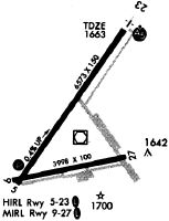
Runways
Runway Summary
| Runways: | 05/23 09/27 |
| Longest Runway: | 05/23 is 6573 ft (2003 m) long |
| Runways with an Instrument Approach: | 23 |
SLK Airport Runway Details
| Runway 05/23 | 6573 ft x 150 ft (2003 m x 46 m) | |
| Runway Length Source: | 3RD PARTY SURVEY as of 02/04/2016 | |
| Surface: | Asphalt - Good condition - Saw-cut or plastic grooved | |
| Runway Pavement Class: | 64 /F/B/W/T | |
| Runway Edge Lights: | High Intensity | |
Runway Weight Bearing Capacity (in thousands of pounds) |
||
| Single Wheel Landing Gear: | 40.0 | |
| Dual Wheel Landing Gear: | 73.0 | |
| Dual Tandem Wheel Landing Gear: | 115.0 | |
Runway 05 |
Runway 23 |
|
Elevation: |
1640.0 | 1662.5 |
Latitude: |
44-22-48.7496N | 44-23-41.9774N |
Longitude: |
074-12-47.7900W | 074-11-56.0158W |
|
Runway True Alignment: |
035 | 215 |
ILS Type: |
ILS | |
Glide Path Angle: |
3.0 degrees | 0.0 degrees |
Traffic Pattern: |
Left | Left |
Runway Markings Type: |
Nonprecision Instrument | Precision Instrument |
Runway Markings Condition: |
Fair | Fair |
Object at End: |
TREES | TREES |
Object Height: |
18 | 7 |
Distance from End: |
387 | 385 |
Object Centerline Offset: |
387 ft. left of centerline | 532 ft. right of centerline |
Visual Glide Slope Indicators: |
4-Light PAPI On Left Side Of Runway | |
Approach Light System: |
1,400 Foot Medium Intensity Approach Lighting System With Runway Alignment Indicator Lights | |
Threshold Crossing Height: |
35 | |
Declared Distances |
||
Take Off Run Avbl. (TORA): |
6573 | 6573 |
Take Off Distance Avbl. (TODA): |
6573 | 6573 |
Actual Stop Dist. Avbl. (ASDA): |
6573 | 6333 |
Landing Dist. Avbl. (LDA): |
6573 | 6333 |
| Runway 09/27 | 3997 ft x 100 ft (1218 m x 30 m) | |
| Runway Length Source: | 3RD PARTY SURVEY as of 02/04/2016 | |
| Surface: | Asphalt - Good condition - No special surface treatment | |
| Runway Pavement Class: | 61 /F/B/W/T | |
| Runway Edge Lights: | Medium Intensity | |
Runway Weight Bearing Capacity (in thousands of pounds) |
||
| Single Wheel Landing Gear: | 40.0 | |
| Dual Wheel Landing Gear: | 73.0 | |
| Dual Tandem Wheel Landing Gear: | 115.0 | |
Runway 09 |
Runway 27 |
|
Elevation: |
1638.8 | 1638.3 |
Latitude: |
44-22-49.8112N | 44-22-57.2587N |
Longitude: |
074-12-49.8412W | 074-11-55.7915W |
|
Runway True Alignment: |
079 | 259 |
Glide Path Angle: |
0.0 degrees | 0.0 degrees |
Traffic Pattern: |
Left | Left |
Runway Markings Type: |
Nonstandard (other than numbers only) | Nonprecision Instrument |
Runway Markings Condition: |
Good | Good |
Object at End: |
TREES | TREES |
Object Height: |
27 | 18 |
Distance from End: |
214 | 387 |
Object Centerline Offset: |
387 ft. left of centerline | 532 ft. right of centerline |
Threshold Elevation: |
1640.1 | |
Displaced Threshold: |
400 | |
Threshold Latitude: |
44-22-56.5167N | |
Threshold Longitude: |
074-12-01.1999W | |
Declared Distances |
||
Take Off Run Avbl. (TORA): |
3997 | 3997 |
Take Off Distance Avbl. (TODA): |
3997 | 3997 |
Actual Stop Dist. Avbl. (ASDA): |
3997 | 3997 |
Landing Dist. Avbl. (LDA): |
3997 | 3597 |
Services
Airframe Repair: |
Major |
Powerplant Repair: |
Major |
Bottled Oxygen: |
None |
Bulk Oxygen: |
None |
Fuel Available: |
100LL, Jet A+ |
Landing Fees: |
No |
Parking: |
Hangars and tiedowns available |
Maps & Diagrams
SLK Sectional
Flight Planning
at skyvector.com
at skyvector.com