Location
Latitude: |
27-27-23.0000N (27.456389) |
Longitude: |
081-20-32.6000W (-81.342389) |
Elevation: |
61.6 feet MSL (19 m MSL) |
Magnetic Variation: |
6.7 W (as of April 2024 from WMM2020 model) |
Time Zone: |
UTC -5.0 (Standard Time) UTC -4.0 (Daylight Savings Time) |
From City: |
06 N.M. SE of Sebring, Florida |
Found On: |
Miami Chart |
FAA Region: |
ASO |
Contacts
Manager: |
Publicly owned: |
| SCOTT CARKEET SEBRING REGIONAL AIRPORT, 128 AUTHORITY LANE SEBRING, FL 33870 863-314-1319 |
SEBRING AIRPORT AUTHORITY 128 AUTHORITY LANE SEBRING, FL 33870 863-655-6444 |
Operations
Airport Status: |
Operational |
Facility Use: |
Public |
Type: |
Airport |
Activation Date: |
12/1942 |
Control tower: |
No |
Attendance (Months/Days/Hours): |
Months/Days/Hours ALL/MON-FRI/0730-1800 |
Boundary ARTCC: |
ZMA (Miami) |
Responsible ARTCC: |
ZMA (Miami) |
Lighting Schedule: |
SEE RMK |
Segmented Circle Indicator: |
Yes, Lighted |
Traffic Pattern Altitude (MSL): |
1062 feet (324 m) |
NOTAMs Facility: |
PIE |
NOTAM-D Service: |
Yes |
International Airport of Entry: |
No |
Customs Landing Rights: |
No |
Military Landing Rights: |
Yes |
Civil/Military Joint Use: |
No |
Based Aircraft
| Single Engine: | 73 |
| Multi Engine: | 19 |
| Jet Engine: | 3 |
| GA Helicopters: | 9 |
Annual Operations (as of 10/09/2020)
| Total Operations: | 72670 | |
| GA Local: | 29795 | 41.0% |
| GA Itinerant: | 42475 | 58.4% |
| Military Aircraft: | 400 | 0.6% |
Communications
| CTAF: | 122.700 |
| Unicom: | 122.700 |
| AWOS-3: | 119.475 (863-655-6424) |
- APCH/DEP SVC PRVDD BY MIAMI ARTCC ON FREQS 134.55/257.7 (AVON PARK RCAG).
Fixed Based Operators (FBOs) & Fuel
(Click on a business for detail)
Please help us keep this information up to date. This is a FREE SERVICE just like everything else on Airport Guide! If you see that a business needs to be added, modified, or deleted please fill out our Update Form.
To add, modify, or delete a business click here.
Please help us keep this information up to date. This is a FREE SERVICE just like everything else on Airport Guide! If you see that a business needs to be added, modified, or deleted please fill out our Update Form.
Area Code: 863 |
| Business Name | Frequency | Phone | Fuel Grade |
|---|---|---|---|
| Carter Aircraft, Inc.
Update FBO info |
863-655-1423 | ||
| Sebring Flight Center
Website Update FBO info |
Unicom 122.7 | 863-655-6455 | 100LL, Jet A |

|
Chevron |
100LL - 1.95 USD per gallon on 12/13/01 |
Trucks Weekend Fuel Specials $1.75 av gas. FTZ 100LL $1.50 Additional 5 cents off with receipt from Runway Cafe, Hobby Hill, Sir Gift Shop, or Chateau Elan. |
|
|
Chevron |
Jet A - 1.70 USD per gallon on 12/13/01 |
Trucks FTZ Jet A $1.40 Additional 5 cents off with receipt from Runway Cafe, Hobby Hill, Sir Gift Shop, or Chateau Elan. |
Flight Service Stations
| Primary | Alternate | |
| FSS on Field: | N | |
| FSS Name (ID): | Saint Petersburg(PIE) | |
| Frequency: | ||
| Toll Free Phone: | 1-800-WX-BRIEF |
Instrument Procedures / Charts
FAA Terminal Procedures valid from 0901Z 03/21/24 to 0901Z 04/18/24.
There are various types of charts available for an airport. They are listed in the Page Type column. Here is a legend for those types:
APD - Airport Diagram
DP - Departure Procedure Charts
HOT - Hot Spots
IAP - Instrument Approach Procedure Charts
MIN - Minimums
STAR - Standard Terminal Arrival Charts
| Page Type | Page Name | Volume | Action Since Last Cycle |
|---|---|---|---|
| IAP | RNAV (GPS) RWY 01 | SE-3 | |
| IAP | RNAV (GPS) RWY 14 | SE-3 | |
| IAP | RNAV (GPS) RWY 32 | SE-3 | |
| IAP | RNAV (RNP) RWY 19 | SE-3 | |
| MIN | ALTERNATE MINIMUMS | SE-3 | |
| MIN | TAKEOFF MINIMUMS | SE-3 |
Terminal Procedures are only available for airports in several countries with more being added all the time. If you are looking for a specific country's charts, please send an email to support(at)airportguide.com stating the country name. This will be used to prioritize the implementation.
Navigation Aids (Navaids) near SEF
| Dist (NM) | ID | Morse Code | Name | Type | Freq | True Hdg | Mag Hdg |
|---|---|---|---|---|---|---|---|
| 37.8 | LBV | . _ . . _ . . . . . . _ | La Belle | VORTAC | 110.40 | 183 | 190 |
| 47.3 | TRV | _ . _ . . . . _ | Treasure | VORTAC | 117.30 | 73 | 80 |
| 47.4 | PGD | . _ _ . _ _ . _ . . | Punta Gorda | VOR | 110.20 | 227 | 233 |
| 47.8 | LAL | . _ . . . _ . _ . . | Lakeland | VORTAC | 116.00 | 311 | 318 |
| 51.5 | SQT | . . . _ _ . _ _ | Satellite | NDB | 257 | 41 | 48 |
| 51.6 | FPR | . . _ . . _ _ . . _ . | Fort Pierce | NDB | 275 | 87 | 94 |
| 53.3 | PHK | . _ _ . . . . . _ . _ | Pahokee | VOR-DME | 115.40 | 139 | 146 |
| 54.1 | MLB | _ _ . _ . . _ . . . | Melbourne | VOR-DME | 115.85 | 43 | 50 |
| 60.2 | RSW | . _ . . . . . _ _ | Lee County | VORTAC | 114.15 | 202 | 209 |
| 60.8 | COF | _ . _ . _ _ _ . . _ . | Patrick | TACAN | 115.00 | 39 | 46 |
| 62.7 | VNC | . . . _ _ . _ . _ . | Venice | NDB | 206 | 248 | 254 |
| 63.0 | UTX | . . _ _ _ . . _ | United | NDB | 405 | 121 | 128 |
| 63.2 | OR | _ _ _ . _ . | Herny | NDB | 221 | 355 | 362 |
| 63.3 | RHZ | . _ . . . . . _ _ . . | Zephyrhills | NDB | 253 | 317 | 324 |
| 65.1 | SRQ | . . . . _ . _ _ . _ | Sarasota | VOR-DME | 117.00 | 267 | 273 |
| 65.1 | FM | . . _ . _ _ | Caloo | NDB | 341 | 210 | 216 |
| 65.2 | ORL | _ _ _ . _ . . _ . . | Orlando | VORTAC | 112.20 | 0 | 7 |
| 66.8 | MCF | _ _ _ . _ . . . _ . | Macdill | TACAN | 111.00 | 291 | 297 |
| 68.4 | AM | . _ _ _ | Picny | NDB | 388 | 291 | 297 |
| 69.7 | TVV | _ . . . _ . . . _ | Space Center Executive | NDB | 237 | 24 | 31 |
Nearby Airports with Fuel
Notices to Airmen (NOTAMS)
Remarks
| A11 | CTC PERSON: MIKE WILLINGHAM 863-314-1300 FAX: 863-655-6444 |
| A110*G | THIS AIRPORT HAS BEEN SURVEYED BY THE NATIONAL GEODETIC SURVEY. |
| A110-1 | FOR CD IF UNA TO CTC ON FSS FREQ, CTC MIAMI ARTCC AT 305-716-1731. |
| A43-19 | UNUSBL BYD 8 DEGS LEFT AND 7 DEGS RIGHT OF COURSE. |
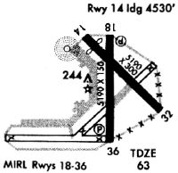
| A57-14 | RWY 14 APCH RATIO 25:1 AT DTHR. |
| A70-FUEL-10 | 0LL FOR FUEL AFT HRS CALL 863-655-6455. |
| A81-APT | ACTVT REILS RWY 1 & 19; PAPI RWY 1 & 19; MIRLS RWY 1/19- CTAF. |
| E111 | EXISTED PRIOR TO 1959. |
Runways
Runway Summary
| Runways: | 01/19 14/32 |
| Longest Runway: | 01/19 is 5234 ft (1595 m) long |
| Runways with an Instrument Approach: |
SEF Airport Runway Details
| Runway 01/19 | 5234 ft x 100 ft (1595 m x 30 m) | |
| Runway Length Source: | NGS as of 04/29/2006 | |
| Surface: | Asphalt - Good condition - No special surface treatment | |
| Runway Pavement Class: | 32 /F/A/X/T | |
| Runway Edge Lights: | Medium Intensity | |
Runway Weight Bearing Capacity (in thousands of pounds) |
||
| Single Wheel Landing Gear: | 26.0 | |
| Dual Wheel Landing Gear: | 50.0 | |
| Dual Tandem Wheel Landing Gear: | 85.0 | |
Runway 01 |
Runway 19 |
|
Elevation: |
55.9 | 58.5 |
Latitude: |
27-26-53.6612N | 27-27-45.4919N |
Longitude: |
081-20-34.9041W | 081-20-35.0973W |
|
Runway True Alignment: |
360 | 180 |
Glide Path Angle: |
3.0 degrees | 3.0 degrees |
Traffic Pattern: |
Left | Left |
Runway Markings Type: |
Nonprecision Instrument | Nonprecision Instrument |
Runway Markings Condition: |
Fair | Fair |
Object at End: |
TREE | TREE |
Object Height: |
50 | 19 |
Distance from End: |
2585 | 950 |
Object Centerline Offset: |
0 ft. left and right of centerline | 45 ft. right of centerline |
Visual Glide Slope Indicators: |
4-Light PAPI On Left Side Of Runway | 4-Light PAPI On Left Side Of Runway |
REIL: |
Yes | Yes |
Threshold Crossing Height: |
42 | 42 |
| Runway 14/32 | 4990 ft x 100 ft (1521 m x 30 m) | |
| Runway Length Source: | NGS as of 02/23/2010 | |
| Surface: | Asphalt - Good condition - No special surface treatment | |
| Runway Pavement Class: | 9 /F/B/Y/T | |
Runway Weight Bearing Capacity (in thousands of pounds) |
||
| Single Wheel Landing Gear: | 26.0 | |
| Dual Wheel Landing Gear: | 50.0 | |
| Dual Tandem Wheel Landing Gear: | 85.0 | |
Runway 14 |
Runway 32 |
|
Elevation: |
53.5 | 57.0 |
Latitude: |
27-27-44.0152N | 27-27-09.1821N |
Longitude: |
081-20-49.7683W | 081-20-10.4865W |
|
Runway True Alignment: |
135 | 315 |
Glide Path Angle: |
0.0 degrees | 0.0 degrees |
Runway Markings Type: |
Basic | Basic |
Runway Markings Condition: |
Good | Good |
Object at End: |
RR | FENCE |
Object Height: |
23 | 6 |
Distance from End: |
486 | 408 |
Object Centerline Offset: |
0 ft. left and right of centerline | 45 ft. right of centerline |
Threshold Elevation: |
54.4 | |
Displaced Threshold: |
289 | |
Threshold Latitude: |
27-27-41.9997N | |
Threshold Longitude: |
081-20-47.4951W |
Services
Airframe Repair: |
None |
Powerplant Repair: |
None |
Bottled Oxygen: |
None |
Bulk Oxygen: |
None |
Fuel Available: |
100LL, Jet A |
Landing Fees: |
No |
Parking: |
Hangars and tiedowns available |
Maps & Diagrams
SEF Sectional
Flight Planning
at skyvector.com
at skyvector.com