Location
Latitude: |
47-50-29.6100N (47.841558) |
Longitude: |
116-15-07.1800W (-116.251994) |
Elevation: |
3002.0 feet MSL (915 m MSL) |
Magnetic Variation: |
13.7 E (as of April 2024 from WMM2020 model) |
Time Zone: |
UTC -8.0 (Standard Time) UTC -7.0 (Daylight Savings Time) |
From City: |
23 N.M. NE of Coeur D'alene, Idaho |
Found On: |
Great Falls Chart |
FAA Region: |
ANM |
Contacts
Manager: |
Publicly owned: |
| DIVISION ADMIN BOX 7129 BOISE, ID 83707-1129 208-334-8775 |
STATE OF IDAHO ITD, DIV AERO BOX 7129 BOISE, ID 83707-1129 208-334-8775 |
Operations
Airport Status: |
Operational |
Facility Use: |
Public |
Type: |
Airport |
Control tower: |
No |
Attendance (Months/Days/Hours): |
Months/Days/Hours Unattended |
Boundary ARTCC: |
ZSE (Seattle) |
Responsible ARTCC: |
ZSE (Seattle) |
Segmented Circle Indicator: |
Yes |
Traffic Pattern Altitude (MSL): |
4002 feet (1220 m) |
NOTAMs Facility: |
BOI |
NOTAM-D Service: |
Yes |
Military Landing Rights: |
No |
Civil/Military Joint Use: |
No |
Based Aircraft
Annual Operations (as of 09/30/2021)
| Total Operations: | 1100 | |
| GA Itinerant: | 1100 | 100.0% |
Communications
| CTAF: | 122.900 |
Fixed Based Operators (FBOs) & Fuel
(Click on a business for detail)
Please help us keep this information up to date. This is a FREE SERVICE just like everything else on Airport Guide! If you see that a business needs to be added, modified, or deleted please fill out our Update Form.
To add, modify, or delete a business click here.
Please help us keep this information up to date. This is a FREE SERVICE just like everything else on Airport Guide! If you see that a business needs to be added, modified, or deleted please fill out our Update Form.
Area Code: 208 |
| Business Name | Frequency | Phone | Fuel Grade |
|---|
Flight Service Stations
| Primary | Alternate | |
| FSS on Field: | N | |
| FSS Name (ID): | Boise(BOI) | |
| Frequency: | ||
| Toll Free Phone: | 1-800-WX-BRIEF |
Instrument Procedures / Charts
Terminal Procedures are only available for airports in several countries with more being added all the time. If you are looking for a specific country's charts, please send an email to support(at)airportguide.com stating the country name. This will be used to prioritize the implementation.
Navigation Aids (Navaids) near S77
| Dist (NM) | ID | Morse Code | Name | Type | Freq | True Hdg | Mag Hdg |
|---|---|---|---|---|---|---|---|
| 23.3 | COE | _ . _ . _ _ _ . | Coeur D'alene | VOR-DME | 108.80 | 260 | 246 |
| 29.2 | LEN | . _ . . . _ . | Post Falls | NDB | 347 | 258 | 244 |
| 29.7 | SZT | . . . _ _ . . _ | Sandpoe | NDB | 264 | 335 | 321 |
| 33.7 | MLP | _ _ . _ . . . _ _ . | Mullan Pass | VOR-DME | 117.80 | 133 | 119 |
| 41.1 | LYI | . _ . . _ . _ _ . . | Libby | NDB | 414 | 47 | 33 |
| 44.1 | SFF | . . . . . _ . . . _ . | Spokane/Felts Field | VOT | 114.00 | 257 | 243 |
| 47.8 | DPY | _ . . . _ _ . _ . _ _ | Deer Park | NDB | 365 | 279 | 265 |
| 49.3 | CRK | _ . _ . . _ . _ . _ | Canyon | NDB | 388 | 258 | 244 |
| 53.3 | GEG | _ _ . . _ _ . | Spokane Intl | VOT | 109.60 | 255 | 241 |
| 57.9 | GEG | _ _ . . _ _ . | Spokane | VORTAC | 115.50 | 253 | 239 |
| 58.6 | SKA | . . . _ . _ . _ | Fairchild | TACAN | 111.40 | 256 | 242 |
| 69.8 | ION | . . _ _ _ _ . | Ione | NDB | 379 | 318 | 304 |
| 72.7 | U6 | Creston | NDB | 360 | 352 | 338 | |
| 73.7 | SAK | . . . . _ _ . _ | Smith Lake | NDB | 515 | 76 | 63 |
| 80.4 | PUW | . _ _ . . . _ . _ _ | Pullman | VOR-DME | 117.15 | 209 | 195 |
| 81.3 | W6 | Creston North | NDB | 233 | 350 | 336 | |
| 81.9 | EUR | . . . _ . _ . | Eureka | NDB | 392 | 34 | 20 |
| 86.2 | FCA | . . _ . _ . _ . . _ | Kalispell | VOR-DME | 113.20 | 74 | 61 |
| 87.6 | INE | . . _ . . | Konna | NDB | 521 | 120 | 107 |
| 91.2 | MQG | _ _ _ _ . _ _ _ . | Nez Perce | VOR-DME | 114.45 | 196 | 182 |
Nearby Airports with Fuel
Notices to Airmen (NOTAMS)
Remarks
| A110-1 | NO WINTER MAINT. |
| A110-2 | RCMD LAND RWY 19; TKOF RWY 01 WHEN WIND CONDS PERMIT. |
| A110-4 | HEAVY SNOWMOBLILE ACTIVITY DURING WINTER MONTHS. |
| A110-6 | FOR CD CTC SEATTLE ARTCC AT 253-351-3694. |
| A30-01/19 | RWY 01/19 FIRST 500 FT OF RWY 19 CLSD APR 1ST - JUL 15TH DUE TO WATER ON RWY. |
| A33-01/19 | FIRST 300 FT OF N END/RWY 19 IS VERY ROUGH. |
| A42-19 | 01/19 EDGES & THRS MARKED WITH WHITE ROCKS. |
| A52-01 | +17 FT ROAD AT 65 FT ON CNTRLN. |
| E111 | ESTABD PRIOR TO 5/15/59. |
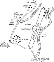
Runways
Runway Summary
| Runways: | 01/19 |
| Longest Runway: | 01/19 is 2200 ft (671 m) long |
| Runways with an Instrument Approach: |
S77 Airport Runway Details
| Runway 01/19 | 2200 ft x 150 ft (671 m x 46 m) | |
| Surface: | Turf - Fair condition - No special surface treatment | |
Runway 01 |
Runway 19 |
|
Glide Path Angle: |
0.0 degrees | 0.0 degrees |
Traffic Pattern: |
Left | Left |
Object at End: |
HILL | BRUSH |
Object Height: |
500 | 15 |
Distance from End: |
900 | 0 |
Object Centerline Offset: |
200 ft. left of centerline | 120 ft. right of centerline |
Displaced Threshold: |
300 |
Services
Airframe Repair: |
None |
Powerplant Repair: |
None |
Bottled Oxygen: |
None |
Bulk Oxygen: |
None |
Fuel Available: |
100LL |
Landing Fees: |
No |
Parking: |
Tiedowns available |
Maps & Diagrams
S77 Sectional
Flight Planning
at skyvector.com
at skyvector.com