Location
Latitude: |
35-30-26.9200N (35.507478) |
Longitude: |
119-11-31.6700W (-119.192131) |
Elevation: |
424.8 feet MSL (129 m MSL) |
Magnetic Variation: |
12 E (as of April 2024 from WMM2020 model) |
Time Zone: |
UTC -8.0 (Standard Time) UTC -7.0 (Daylight Savings Time) |
From City: |
04 N.M. E of Shafter, California |
Found On: |
Los Angeles Chart |
FAA Region: |
AWP |
Contacts
Manager: |
Publicly owned: |
| JONATHAN HUDSON 201 AVIATION ST SHAFTER, CA 93263 (661) 303-6996 |
MINTER FIELD AIRPORT DISTRICT 201 AVIATION ST SHAFTER, CA 93263 661-393-0402 |
Operations
Airport Status: |
Operational |
Facility Use: |
Public |
Type: |
Airport |
Activation Date: |
03/1948 |
Control tower: |
No |
Attendance (Months/Days/Hours): |
Months/Days/Hours ALL/MON-FRI/0800-1700 |
Boundary ARTCC: |
ZLA (Los Angeles) |
Responsible ARTCC: |
ZLA (Los Angeles) |
Lighting Schedule: |
SEE RMK |
Segmented Circle Indicator: |
Yes |
Traffic Pattern Altitude (MSL): |
1425 feet (434 m) |
NOTAMs Facility: |
RIU |
NOTAM-D Service: |
Yes |
International Airport of Entry: |
No |
Customs Landing Rights: |
No |
Military Landing Rights: |
Yes |
Civil/Military Joint Use: |
No |
Based Aircraft
| Single Engine: | 91 |
| Multi Engine: | 7 |
| Jet Engine: | 7 |
| GA Helicopters: | 2 |
| Gliders: | 1 |
Annual Operations (as of 12/05/2023)
| Total Operations: | 45000 | |
| GA Local: | 20000 | 44.4% |
| GA Itinerant: | 25000 | 55.6% |
Communications
| CTAF: | 122.900 |
| Approach: | BAKERSFIELD 126.45 126.45 L.A. CENTER ARTCC |
| Departure: | BAKERSFIELD 126.45 126.45 L.A. CENTER ARTCC |
| AWOS-3: | 121.125 (661-393-8596) |
- APCH/DEP CTL SVC PRVDD BY LOS ANGELES ARTCC (ZLA) ON FREQS 127.1/317.7 (BAKERSFIELD RCAG) WHEN BAKERSFIELD APCH CTL (BFL) CLSD.
Fixed Based Operators (FBOs) & Fuel
(Click on a business for detail)
Please help us keep this information up to date. This is a FREE SERVICE just like everything else on Airport Guide! If you see that a business needs to be added, modified, or deleted please fill out our Update Form.
To add, modify, or delete a business click here.
Please help us keep this information up to date. This is a FREE SERVICE just like everything else on Airport Guide! If you see that a business needs to be added, modified, or deleted please fill out our Update Form.
Area Code: 805 |
| Business Name | Frequency | Phone | Fuel Grade |
|---|---|---|---|
| Birds Nest
Update FBO info |
399-4655 | ||
| Flying M Aviation
Update FBO info |
393-7826 | ||
| Inland Aviation
Update FBO info |
746-2727 | 100LL, Jet A | |
| Klassen Enterprises
Update FBO info |
399-8948 | ||
| Massey Aircraft Service
Update FBO info |
392-0838 | ||
| Warbirds Unlimited
Update FBO info |
393-7260 | ||
| Wood Wing Specialty
Update FBO info |
391-9464 |
Flight Service Stations
| Primary | Alternate | |
| FSS on Field: | N | |
| FSS Name (ID): | Rancho Murieta(RIU) | |
| Frequency: | ||
| Toll Free Phone: | 1-800-WX-BRIEF |
Instrument Procedures / Charts
FAA Terminal Procedures valid from 0901Z 03/21/24 to 0901Z 04/18/24.
There are various types of charts available for an airport. They are listed in the Page Type column. Here is a legend for those types:
APD - Airport Diagram
DP - Departure Procedure Charts
HOT - Hot Spots
IAP - Instrument Approach Procedure Charts
MIN - Minimums
STAR - Standard Terminal Arrival Charts
| Page Type | Page Name | Volume | Action Since Last Cycle |
|---|---|---|---|
| IAP | RNAV (GPS) RWY 12 | SW-3 | |
| IAP | VOR-A | SW-3 | |
| MIN | TAKEOFF MINIMUMS | SW-3 |
Terminal Procedures are only available for airports in several countries with more being added all the time. If you are looking for a specific country's charts, please send an email to support(at)airportguide.com stating the country name. This will be used to prioritize the implementation.
Navigation Aids (Navaids) near MIT
| Dist (NM) | ID | Morse Code | Name | Type | Freq | True Hdg | Mag Hdg |
|---|---|---|---|---|---|---|---|
| 4.8 | EHF | . . . . . . . _ . | Shafter | VORTAC | 115.40 | 106 | 94 |
| 8.7 | BFL | _ . . . . . _ . . _ . . | Bakersfield | VOT | 111.20 | 124 | 112 |
| 25.7 | TTE | _ _ . | Tule | VOR-DME | 116.25 | 18 | 6 |
| 37.4 | COR | _ . _ . _ _ _ . _ . | Salyer Farms | NDB | 205 | 333 | 321 |
| 39.3 | AVE | . _ . . . _ . | Avenal | VOR-DME | 117.10 | 282 | 270 |
| 41.3 | FLW | . . _ . . _ . . . _ _ | Fellows | VOR-DME | 117.50 | 233 | 221 |
| 45.2 | GMN | _ _ . _ _ _ . | Gorman | VORTAC | 116.10 | 158 | 146 |
| 53.5 | VIS | . . . _ . . . . . | Visalia | VOR-DME | 109.40 | 344 | 332 |
| 58.0 | LHS | . _ . . . . . . . . . | Lake Hughes | VORTAC | 114.35 | 148 | 136 |
| 62.7 | NLC | _ . . _ . . _ . _ . | Lemoore | TACAN | 113.30 | 323 | 311 |
| 66.3 | RZS | . _ . _ _ . . . . . | San Marcus | VORTAC | 114.90 | 205 | 193 |
| 70.7 | PRB | . _ _ . . _ . _ . . . | Paso Robles | VORTAC | 114.30 | 278 | 266 |
| 70.7 | FIM | . . _ . . . _ _ | Fillmore | VORTAC | 112.50 | 167 | 155 |
| 73.2 | GLJ | _ _ . . _ . . . _ _ _ | Guadalupe | VOR | 113.05 | 243 | 231 |
| 73.4 | GVO | _ _ . . . . _ _ _ _ | Gaviota | VORTAC | 113.80 | 217 | 205 |
| 74.1 | NID | _ . . . _ . . | China Lake | TACAN | 111.60 | 81 | 69 |
| 76.4 | PMD | . _ _ . _ _ _ . . | Palmdale | VORTAC | 114.50 | 133 | 121 |
| 77.8 | CMA | _ . _ . _ _ . _ | Camarillo | VOR-DME | 115.80 | 176 | 164 |
| 78.1 | EDW | . _ . . . _ _ | Edwards | VORTAC | 116.40 | 113 | 101 |
| 78.2 | MQO | _ _ _ _ . _ _ _ _ | Morro Bay | VORTAC | 112.40 | 259 | 247 |
Nearby Airports with Fuel
Notices to Airmen (NOTAMS)
Remarks
| A110-1 | HEAVY CROP DUSTER ACTIVITY INVOF ARPT. |
| A110-2 | FUEL 24 HR CREDIT CARD SVC AVBL. |
| A110-3 | ULTRALIGHT ACTIVITY ON & INVOF ARPT. |
| A110-4 | RY 30 PREFERRED CALM WIND RY. |
| A110-5 | RYS 26 AND 08 USED EXTENSIVELY BY AERIAL APPLICATOR ACFT. RECOMMEND EXTENSIVE USAGE OF CTAF FOR POSITION REPORTING. |
| A110-6 | FOR CD CTC LOS ANGELES ARTCC AT 661-575-2079. |
| A13 | AFTER HOURS 661-303-6996 |
| A57-08 | 33:1 TO DSPLCD THLD. |
| A57-26 | 28:1 TO THE DSPLCD THLD. |
| A81-APT | ACTVT REIL RWY 12 & 30; PAPI RWY 30; MIRL RWY 12/30 - CTAF. |
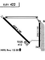
Runways
Runway Summary
| Runways: | 08/26 12/30 17/35 |
| Longest Runway: | 12/30 is 4501 ft (1372 m) long |
| Runways with an Instrument Approach: |
MIT Airport Runway Details
| Runway 08/26 | 3680 ft x 60 ft (1122 m x 18 m) | |
| Runway Length Source: | 3RD PARTY SURVEY as of 01/19/2021 | |
| Surface: | Asphalt - Good condition - No special surface treatment | |
Runway Weight Bearing Capacity (in thousands of pounds) |
||
| Single Wheel Landing Gear: | 125.0 | |
Runway 08 |
Runway 26 |
|
Elevation: |
413.7 | 424.6 |
Latitude: |
35-30-38.0625N | 35-30-38.0256N |
Longitude: |
119-11-56.8703W | 119-11-12.3623W |
|
Runway True Alignment: |
090 | 270 |
Glide Path Angle: |
0.0 degrees | 0.0 degrees |
Traffic Pattern: |
Right | |
Runway Markings Type: |
Basic | Basic |
Runway Markings Condition: |
Good | Good |
Object at End: |
TREES | BLDG |
Object Height: |
60 | 20 |
Distance from End: |
1896 | 411 |
Object Centerline Offset: |
190 ft. right of centerline | 0 ft. left and right of centerline |
Centerline Lights: |
No | No |
Threshold Elevation: |
413.8 | 424.5 |
Displaced Threshold: |
140 | 166 |
Threshold Latitude: |
35-30-38.0622N | 35-30-38.0269N |
Threshold Longitude: |
119-11-55.1768W | 119-11-14.3691W |
| Runway 12/30 | 4501 ft x 100 ft (1372 m x 30 m) | |
| Runway Length Source: | 3RD PARTY SURVEY as of 01/19/2021 | |
| Surface: | Asphalt - Good condition - No special surface treatment | |
| Runway Edge Lights: | Medium Intensity | |
Runway Weight Bearing Capacity (in thousands of pounds) |
||
| Single Wheel Landing Gear: | 22.0 | |
Runway 12 |
Runway 30 |
|
Elevation: |
412.5 | 412.2 |
Latitude: |
35-30-38.4409N | 35-30-07.8814N |
Longitude: |
119-12-03.6901W | 119-11-24.1102W |
|
Runway True Alignment: |
133 | 313 |
Glide Path Angle: |
0.0 degrees | 3.0 degrees |
Traffic Pattern: |
Right | Left |
Runway Markings Type: |
Nonprecision Instrument | Nonprecision Instrument |
Runway Markings Condition: |
Good | Good |
Object Centerline Offset: |
190 ft. right of centerline | 0 ft. left and right of centerline |
Visual Glide Slope Indicators: |
4-Light PAPI On Left Side Of Runway | |
REIL: |
Yes | Yes |
Touchdown Lights: |
No | No |
Centerline Lights: |
No | No |
Threshold Crossing Height: |
42 |
| Runway 17/35 | 2972 ft x 100 ft (906 m x 30 m) | |
| Runway Length Source: | 3RD PARTY SURVEY as of 01/19/2021 | |
| Surface: | Asphalt - Good condition - No special surface treatment | |
Runway Weight Bearing Capacity (in thousands of pounds) |
||
| Single Wheel Landing Gear: | 25.0 | |
| Dual Wheel Landing Gear: | 30.0 | |
Runway 17 |
Runway 35 |
|
Elevation: |
423.1 | 414.3 |
Latitude: |
35-30-33.5318N | 35-30-04.1396N |
Longitude: |
119-11-09.4905W | 119-11-09.5173W |
|
Runway True Alignment: |
180 | 000 |
Glide Path Angle: |
0.0 degrees | 0.0 degrees |
Traffic Pattern: |
Right | Left |
Runway Markings Type: |
Basic | Basic |
Runway Markings Condition: |
Good | Good |
Object at End: |
ROAD | ROAD |
Object Height: |
15 | 15 |
Distance from End: |
850 | 470 |
Object Centerline Offset: |
190 ft. right of centerline | 0 ft. left and right of centerline |
REIL: |
No | No |
Touchdown Lights: |
No | No |
Centerline Lights: |
No | No |
Services
Fuel Available: |
100LL |
Landing Fees: |
No |
Parking: |
Tiedowns available |
Other Services: |
We have a Flight Service Center that has a little conference room, couch, soda machine, microwave. Hangars: $115 per month, we currently have 4 vacancies Tiedowns: $22 per month Car Parking: $5 per day or $25 per month Maintenance Hanger: 3000 sq foot hanger for someone interested in doing some sort of business. |
Maps & Diagrams
MIT Sectional
Flight Planning
at skyvector.com
at skyvector.com