Location
Latitude: |
63-53-09.5000N (63.885972) |
Longitude: |
152-18-06.6000W (-152.301833) |
Elevation: |
681.8 feet MSL (208 m MSL) |
Magnetic Variation: |
13.9 E (as of April 2024 from WMM2020 model) |
Time Zone: |
UTC -9.0 (Standard Time) UTC -8.0 (Daylight Savings Time) |
From City: |
00 N.M. SE of Minchumina, Alaska |
Found On: |
Mc Grath Chart |
FAA Region: |
AAL |
Contacts
Manager: |
Publicly owned: |
| JASON LUDINGTON 2301 PEGER RD FAIRBANKS, AK 99709 (907) 451-5280 |
ALASKA DOT&PF NORTHERN REGION NORTHERN REGION, 2301 PEGER ROAD FAIRBANKS, AK 99709 (907) 451-5280 |
Operations
Airport Status: |
Operational |
Facility Use: |
Public |
Type: |
Airport |
Activation Date: |
08/1947 |
Control tower: |
No |
Attendance (Months/Days/Hours): |
Months/Days/Hours Unattended |
Boundary ARTCC: |
ZAN (Anchorage) |
Responsible ARTCC: |
ZAN (Anchorage) |
Lighting Schedule: |
SEE RMK |
Segmented Circle Indicator: |
Yes |
Traffic Pattern Altitude (MSL): |
1682 feet (513 m) |
NOTAMs Facility: |
MHM |
NOTAM-D Service: |
Yes |
International Airport of Entry: |
No |
Customs Landing Rights: |
No |
Military Landing Rights: |
Yes |
Civil/Military Joint Use: |
No |
Based Aircraft
| Single Engine: | 2 |
Annual Operations (as of 12/31/2020)
| Total Operations: | 1140 | |
| Air Taxi: | 40 | 3.5% |
| GA Local: | 100 | 8.8% |
| GA Itinerant: | 1000 | 87.7% |
Communications
| CTAF: | 122.900 |
| AWOS-3P: | 135.55 (907-674-3315) |
- COMMUNICATIONS PRVDD BY FAIRBANKS FSS ON FREQ 122.20 (MINCHUMINA RCO).
- APCH/DEP SVC PRVDD BY ANCHORAGE ARTCC ON FREQS 120.9/319.2 (MURPHY DOME RCAG).
Fixed Based Operators (FBOs) & Fuel
(Click on a business for detail)
Please help us keep this information up to date. This is a FREE SERVICE just like everything else on Airport Guide! If you see that a business needs to be added, modified, or deleted please fill out our Update Form.
To add, modify, or delete a business click here.
Please help us keep this information up to date. This is a FREE SERVICE just like everything else on Airport Guide! If you see that a business needs to be added, modified, or deleted please fill out our Update Form.
Area Code: 907 |
| Business Name | Frequency | Phone | Fuel Grade |
|---|
Flight Service Stations
| Primary | Alternate | |
| FSS on Field: | N | |
| FSS Name (ID): | Fairbanks(FAI) | |
| Frequency: | ||
| Toll Free Phone: | 1-866-248-6516 |
Instrument Procedures / Charts
FAA Terminal Procedures valid from 0901Z 03/21/24 to 0901Z 04/18/24.
There are various types of charts available for an airport. They are listed in the Page Type column. Here is a legend for those types:
APD - Airport Diagram
DP - Departure Procedure Charts
HOT - Hot Spots
IAP - Instrument Approach Procedure Charts
MIN - Minimums
STAR - Standard Terminal Arrival Charts
| Page Type | Page Name | Volume | Action Since Last Cycle |
|---|---|---|---|
| IAP | NDB RWY 03 | AK-1 | |
| IAP | RNAV (GPS) RWY 03 | AK-1 | Changed |
| IAP | RNAV (GPS) RWY 21 | AK-1 | Changed |
| MIN | ALTERNATE MINIMUMS | AK-1 | |
| MIN | TAKEOFF MINIMUMS | AK-1 |
Terminal Procedures are only available for airports in several countries with more being added all the time. If you are looking for a specific country's charts, please send an email to support(at)airportguide.com stating the country name. This will be used to prioritize the implementation.
Navigation Aids (Navaids) near LMA
| Dist (NM) | ID | Morse Code | Name | Type | Freq | True Hdg | Mag Hdg |
|---|---|---|---|---|---|---|---|
| 0.4 | MHM | _ _ . . . . _ _ | Minchumina | NDB | 227 | 251 | 237 |
| 77.3 | BCC | _ . . . _ . _ . _ . _ . | Bear Creek | NDB | 212 | 1 | 347 |
| 77.5 | TAL | _ . _ . _ . . | Tanana | VOR-DME | 116.60 | 2 | 348 |
| 91.3 | UMM | . . _ _ _ _ _ | Summit | NDB | 326 | 110 | 96 |
| 93.0 | ICW | . . _ . _ . . _ _ | Ice Pool | NDB | 525 | 63 | 48 |
| 94.2 | ENN | . _ . _ . | Nenana | VORTAC | 115.80 | 61 | 46 |
Nearby Airports with Fuel
| Dist (NM) | Name (Airport IDs) | True Hdg | Mag Hdg | Fuel Grade |
|---|---|---|---|---|
| 93.1 | Nenana Municipal Airport (ENN PANN ENN) |
63 | 48 | 100LL, Jet A |
| 93.9 | Cantwell Airport (PATW TTW) |
106 | 91 | 100LL |
Notices to Airmen (NOTAMS)
Remarks
| A110-2 | BLM FIRE FIGHTING EQUIP & ACFT OPR DURG SUMMER MONTHS. |
| A110-4 | RWY COND NOT MNT; RCMD VSB INSP PRIOR TO LNDG. |
| A110-5 | SNOW REMOVAL OPS - CTAF. |
| A110-7 | WX CAMERA AVBL ON INTERNET AT HTTPS://WEATHERCAMS.FAA.GOV |
| A110-8 | ALERT: CLSD CROSS RWY WITH FADED MARKINGS W OF RWY 03 THR. |
| A110-9 | COLD TEMPERATURE AIRPORT. ALTITUDE CORRECTION REQUIRED AT OR BELOW -37C. |
| A75 | TSNT TIE DOWN POINT AVBL. |
| A81-APT | ACTVT PAPI RWY 03; MIRL RWY 03/21 - CTAF. |
| A83 | INACCURATE; SURROUNDED BY TREES. |
Runways
Runway Summary
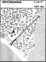
| Runways: | 03/21 |
| Longest Runway: | 03/21 is 4184 ft (1275 m) long |
| Runways with an Instrument Approach: |
LMA Airport Runway Details
| Runway 03/21 | 4184 ft x 100 ft (1275 m x 30 m) | |
| Runway Length Source: | 3RD PARTY SURVEY as of 08/28/2010 | |
| Surface: | Gravel - Good condition - No special surface treatment | |
| Runway Edge Lights: | Medium Intensity | |
Runway 03 |
Runway 21 |
|
Elevation: |
672.7 | 679.8 |
Latitude: |
63-52-54.9675N | 63-53-24.1016N |
Longitude: |
152-18-39.6503W | 152-17-33.6187W |
|
Runway True Alignment: |
045 | 225 |
Glide Path Angle: |
3.0 degrees | 0.0 degrees |
Traffic Pattern: |
Left | Left |
Runway Markings Type: |
Nonstandard (other than numbers only) | Nonstandard (other than numbers only) |
Object at End: |
TREES | TREES |
Object Height: |
6 | 32 |
Distance from End: |
0 | 0 |
Object Centerline Offset: |
224 ft. right of centerline | 213 ft. right of centerline |
Visual Glide Slope Indicators: |
4-Light PAPI On Left Side Of Runway | |
Threshold Crossing Height: |
35 |
Services
Fuel Available: |
100LL |
Maps & Diagrams
LMA Sectional
Flight Planning
at skyvector.com
at skyvector.com