Location
Latitude: |
38-55-46.9000N (38.929694) |
Longitude: |
090-25-47.9000W (-90.429972) |
Elevation: |
436.7 feet MSL (133 m MSL) |
Magnetic Variation: |
1.8 W (as of April 2024 from WMM2020 model) |
Time Zone: |
UTC -6.0 (Standard Time) UTC -5.0 (Daylight Savings Time) |
From City: |
09 N.M. NE of St. Charles, Missouri |
Found On: |
St Louis Chart |
FAA Region: |
ACE |
Contacts
Manager: |
Publicly owned: |
| DENNIS WISS 6390 GRAFTON FERRY RD PORTAGE DES SIOUX, MO 63373 636-949-1893 |
ST CHARLES COUNTY 201 N. 2ND ST. ST CHARLES, MO 63301 636-949-7500 |
Operations
Airport Status: |
Operational |
Facility Use: |
Public |
Type: |
Airport |
Activation Date: |
05/1941 |
Control tower: |
No |
Attendance (Months/Days/Hours): |
Months/Days/Hours APR-OCT/ALL/0800-DUSK |
Boundary ARTCC: |
ZKC (Kansas City) |
Responsible ARTCC: |
ZKC (Kansas City) |
Lighting Schedule: |
SEE RMK |
Segmented Circle Indicator: |
Yes |
Traffic Pattern Altitude (MSL): |
1437 feet (438 m) |
NOTAMs Facility: |
SET |
NOTAM-D Service: |
Yes |
International Airport of Entry: |
No |
Customs Landing Rights: |
No |
Military Landing Rights: |
Yes |
Civil/Military Joint Use: |
No |
Based Aircraft
| Single Engine: | 110 |
| Multi Engine: | 4 |
| GA Helicopters: | 4 |
| Gliders: | 1 |
Annual Operations (as of 12/31/2021)
| Total Operations: | 63764 | |
| Air Taxi: | 110 | 0.2% |
| GA Local: | 49434 | 77.5% |
| GA Itinerant: | 14220 | 22.3% |
Communications
| CTAF: | 122.700 |
| Unicom: | 122.700 |
| Clearance Del.: | 121.6 121.6 121.6 |
| Approach: | SAINT LOUIS |
| Departure: | SAINT LOUIS |
| ASOS: | 118.075 (636-250-4590) |
Fixed Based Operators (FBOs) & Fuel
(Click on a business for detail)
Please help us keep this information up to date. This is a FREE SERVICE just like everything else on Airport Guide! If you see that a business needs to be added, modified, or deleted please fill out our Update Form.
To add, modify, or delete a business click here.
Please help us keep this information up to date. This is a FREE SERVICE just like everything else on Airport Guide! If you see that a business needs to be added, modified, or deleted please fill out our Update Form.
Area Code: 636 |
| Business Name | Frequency | Phone | Fuel Grade |
|---|---|---|---|
| C-D Aircraft Company, Inc.
Update FBO info |
Unicom 126.3 | 250-3665 | 100LL |
| Confederate Air Force Missouri Wing
Update FBO info |
250-4515 | 100LL |
Flight Service Stations
| Primary | Alternate | |
| FSS on Field: | N | |
| FSS Name (ID): | Saint Louis(STL) | |
| Frequency: | ||
| Toll Free Phone: | 1-800-WX-BRIEF |
Instrument Procedures / Charts
FAA Terminal Procedures valid from 0901Z 03/21/24 to 0901Z 04/18/24.
There are various types of charts available for an airport. They are listed in the Page Type column. Here is a legend for those types:
APD - Airport Diagram
DP - Departure Procedure Charts
HOT - Hot Spots
IAP - Instrument Approach Procedure Charts
MIN - Minimums
STAR - Standard Terminal Arrival Charts
| Page Type | Page Name | Volume | Action Since Last Cycle |
|---|---|---|---|
| IAP | RNAV (GPS) RWY 18 | NC-3 | |
| IAP | VOR RWY 18 | NC-3 | |
| MIN | ALTERNATE MINIMUMS | NC-3 | |
| MIN | TAKEOFF MINIMUMS | NC-3 |
Terminal Procedures are only available for airports in several countries with more being added all the time. If you are looking for a specific country's charts, please send an email to support(at)airportguide.com stating the country name. This will be used to prioritize the implementation.
Navigation Aids (Navaids) near KSET
| Dist (NM) | ID | Morse Code | Name | Type | Freq | True Hdg | Mag Hdg |
|---|---|---|---|---|---|---|---|
| 4.8 | STL | . . . _ . _ . . | St Louis | VORTAC | 117.40 | 210 | 212 |
| 8.0 | LM | . _ . . _ _ | Oblio | NDB | 338 | 195 | 197 |
| 11.0 | ST | . . . _ | Zumay | NDB | 404 | 140 | 142 |
| 11.1 | CSX | _ . _ . . . . _ . . _ | Cardinal | DME | 116.45 | 163 | 165 |
| 11.6 | STL | . . . _ . _ . . | St Louis Lambert | VOT | 111.00 | 165 | 167 |
| 16.1 | FZ | . . _ . _ _ . . | Eaves | NDB | 227 | 199 | 201 |
| 17.6 | CVM | _ . _ . . . . _ _ _ | Civic Memorial | NDB | 263 | 97 | 99 |
| 19.1 | SUS | . . . . . _ . . . | Spirit Of St Louis | VOT | 112.20 | 212 | 214 |
| 23.4 | AL | . _ . _ . . | Alpos | NDB | 218 | 100 | 102 |
| 23.5 | SU | . . . . . _ | Snoop | NDB | 326 | 222 | 224 |
| 26.5 | TOY | _ _ _ _ _ . _ _ | Troy | VORTAC | 116.00 | 115 | 117 |
| 29.0 | FTZ | . . _ . _ _ _ . . | Foristell | VORTAC | 110.80 | 241 | 243 |
| 30.1 | CP | _ . _ . . _ _ . | Acore | NDB | 350 | 144 | 146 |
| 35.6 | SKE | . . . _ . _ . | Scott | TACAN | 112.20 | 130 | 132 |
| 42.1 | BL | _ . . . . _ . . | Belleville | NDB | 362 | 131 | 133 |
| 42.2 | JD | . _ _ _ _ . . | Gooey | NDB | 385 | 129 | 131 |
| 44.1 | FES | . . _ . . . . . | Festus | NDB | 269 | 177 | 179 |
| 51.6 | IJX | . . . _ _ _ _ . . _ | Jacksonville | DME | 108.6 | 9 | 11 |
| 54.0 | UUV | . . _ . . _ . . . _ | Sullivan | NDB | 356 | 219 | 221 |
| 59.4 | SP | . . . . _ _ . | Huskk | NDB | 382 | 31 | 33 |
Nearby Airports with Fuel
Notices to Airmen (NOTAMS)
Remarks
| A110*G | THIS AIRPORT HAS BEEN SURVEYED BY THE NATIONAL GEODETIC SURVEY. |
| A110-2 | HEAVY STUDENT TRNG. |
| A110-3 | ARPT CONDS NOT REPORTED MON-FRI 1630L-0800L DLY, FRI 1630L THRU MON 0800L. |
| A110-4 | FOR CD CTC ST LOUIS APCH AT 314-890-1017. |
| A81-APT | ACTVT MIRL RWY 18/36 AND RWY 09/27 & REIL RWY 18, PAPI RWY 18, VASI RWY 36 - CTAF. DUSK TO DAWN ONLY. |
Runways
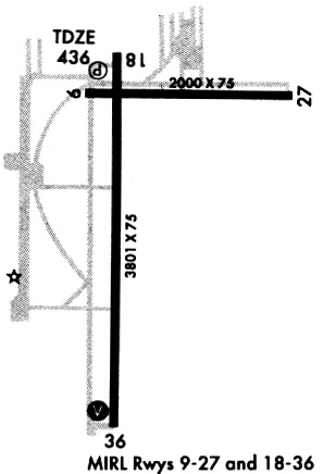
Runway Summary
| Runways: | 09/27 18/36 |
| Longest Runway: | 18/36 is 3800 ft (1158 m) long |
| Runways with an Instrument Approach: |
KSET Airport Runway Details
| Runway 09/27 | 2000 ft x 75 ft (610 m x 23 m) | |
| Runway Length Source: | NGS as of 05/11/2006 | |
| Surface: | Asphalt - Good condition - No special surface treatment | |
| Runway Edge Lights: | Medium Intensity | |
Runway Weight Bearing Capacity (in thousands of pounds) |
||
| Single Wheel Landing Gear: | 12.5 | |
Runway 09 |
Runway 27 |
|
Elevation: |
433.9 | 435.6 |
Latitude: |
38-55-56.5785N | 38-55-56.3292N |
Longitude: |
090-25-54.0531W | 090-25-28.7415W |
|
Runway True Alignment: |
091 | 271 |
Glide Path Angle: |
0.0 degrees | 0.0 degrees |
Traffic Pattern: |
Left | Left |
Runway Markings Type: |
Basic | Basic |
Runway Markings Condition: |
Good | Fair |
| Runway 18/36 | 3800 ft x 75 ft (1158 m x 23 m) | |
| Runway Length Source: | NGS as of 05/11/2006 | |
| Surface: | Asphalt - Good condition - No special surface treatment | |
| Runway Edge Lights: | Medium Intensity | |
Runway Weight Bearing Capacity (in thousands of pounds) |
||
| Single Wheel Landing Gear: | 12.5 | |
Runway 18 |
Runway 36 |
|
Elevation: |
432.9 | 436.4 |
Latitude: |
38-56-00.6303N | 38-55-23.0723N |
Longitude: |
090-25-50.9741W | 090-25-51.5495W |
|
Runway True Alignment: |
181 | 001 |
Glide Path Angle: |
3.0 degrees | 3.0 degrees |
Traffic Pattern: |
Left | Left |
Runway Markings Type: |
Nonprecision Instrument | Nonprecision Instrument |
Runway Markings Condition: |
Good | Fair |
Visual Glide Slope Indicators: |
4-Light PAPI On Left Side Of Runway | 4-Box VASI On Left Side Of Runway |
REIL: |
Yes | |
Threshold Crossing Height: |
40 | 41 |
Services
Airframe Repair: |
Major |
Powerplant Repair: |
Major |
Bottled Oxygen: |
None |
Bulk Oxygen: |
None |
Fuel Available: |
100LL, Jet A, MOGAS |
Landing Fees: |
No |
Parking: |
Tiedowns available |
Maps & Diagrams
KSET Sectional
Flight Planning
at skyvector.com
at skyvector.com