Location
Latitude: |
46-00-53.6000N (46.014889) |
Longitude: |
102-39-21.6000W (-102.656) |
Elevation: |
2705.8 feet MSL (825 m MSL) |
Magnetic Variation: |
6.8 E (as of April 2024 from WMM2020 model) |
Time Zone: |
UTC -7.0 (Standard Time) UTC -6.0 (Daylight Savings Time) |
From City: |
01 N.M. NW of Hettinger, North Dakota |
Found On: |
Billings Chart |
FAA Region: |
AGL |
Contacts
Manager: |
Publicly owned: |
| JAY B. LINDQUIST PO BOX 429 HETTINGER, ND 58639 701-567-2069 |
ADAMS CO ARPT AUTH BOX 429 HETTINGER, ND 58639 701-567-2069 |
Operations
Airport Status: |
Operational |
Facility Use: |
Public |
Type: |
Airport |
Activation Date: |
01/1947 |
Control tower: |
No |
Attendance (Months/Days/Hours): |
Months/Days/Hours ALL/MON-SAT/0700-1700 |
Boundary ARTCC: |
ZMP (Minneapolis) |
Responsible ARTCC: |
ZMP (Minneapolis) |
Lighting Schedule: |
SEE RMK |
Segmented Circle Indicator: |
Yes |
Traffic Pattern Altitude (MSL): |
3706 feet (1130 m) |
NOTAMs Facility: |
HEI |
NOTAM-D Service: |
Yes |
International Airport of Entry: |
No |
Customs Landing Rights: |
No |
Military Landing Rights: |
Yes |
Civil/Military Joint Use: |
No |
Based Aircraft
| Single Engine: | 31 |
| Multi Engine: | 1 |
Annual Operations (as of 10/15/2019)
| Total Operations: | 5250 | |
| Air Taxi: | 400 | 7.6% |
| GA Local: | 3000 | 57.1% |
| GA Itinerant: | 1800 | 34.3% |
| Military Aircraft: | 50 | 1.0% |
Communications
| CTAF: | 122.800 |
| Unicom: | 122.800 |
| ASOS: | 119.925 (701-567-4594) |
- APCH/DEP SVC PRVDD BY MINNEAPOLIS ARTCC ON FREQS 124.25/236.825 (DICKINSON RCAG).
Fixed Based Operators (FBOs) & Fuel
(Click on a business for detail)
Please help us keep this information up to date. This is a FREE SERVICE just like everything else on Airport Guide! If you see that a business needs to be added, modified, or deleted please fill out our Update Form.
To add, modify, or delete a business click here.
Please help us keep this information up to date. This is a FREE SERVICE just like everything else on Airport Guide! If you see that a business needs to be added, modified, or deleted please fill out our Update Form.
Area Code: 701 |
| Business Name | Frequency | Phone | Fuel Grade |
|---|---|---|---|
| Air Dakota
Update FBO info |
567-2069 | 100LL |
Flight Service Stations
| Primary | Alternate | |
| FSS on Field: | N | |
| FSS Name (ID): | Grand Forks(GFK) | |
| Frequency: | ||
| Toll Free Phone: | 1-800-WX-BRIEF |
Instrument Procedures / Charts
FAA Terminal Procedures valid from 0901Z 03/21/24 to 0901Z 04/18/24.
There are various types of charts available for an airport. They are listed in the Page Type column. Here is a legend for those types:
APD - Airport Diagram
DP - Departure Procedure Charts
HOT - Hot Spots
IAP - Instrument Approach Procedure Charts
MIN - Minimums
STAR - Standard Terminal Arrival Charts
| Page Type | Page Name | Volume | Action Since Last Cycle |
|---|---|---|---|
| IAP | RNAV (GPS) RWY 12 | NC-1 | |
| IAP | RNAV (GPS) RWY 30 | NC-1 | |
| MIN | ALTERNATE MINIMUMS | NC-1 | |
| MIN | TAKEOFF MINIMUMS | NC-1 |
Terminal Procedures are only available for airports in several countries with more being added all the time. If you are looking for a specific country's charts, please send an email to support(at)airportguide.com stating the country name. This will be used to prioritize the implementation.
Navigation Aids (Navaids) near KHEI
| Dist (NM) | ID | Morse Code | Name | Type | Freq | True Hdg | Mag Hdg |
|---|---|---|---|---|---|---|---|
| 23.7 | LEM | . _ . . . _ _ | Lemmon | VOR | 111.40 | 103 | 96 |
| 33.7 | BOD | _ . . . _ _ _ _ . . | Bowman | NDB | 374 | 287 | 280 |
| 40.5 | DI | _ . . . . | Noson | NDB | 353 | 356 | 349 |
| 43.5 | BUA | _ . . . . . _ . _ | Buffalo | DME | 109.4 | 230 | 223 |
| 50.9 | DIK | _ . . . . _ . _ | Dickinson | VORTAC | 112.90 | 354 | 347 |
| 68.7 | DPR | _ . . . _ _ . . _ . | Dupree | VOR-DME | 116.80 | 144 | 138 |
| 69.4 | BKU | _ . . . _ . _ . . _ | Timber | NDB | 344 | 287 | 280 |
| 92.7 | BI | _ . . . . . | Jadan | NDB | 230 | 63 | 57 |
| 93.8 | BIS | _ . . . . . . . . | Bismarck | VOR-DME | 115.65 | 60 | 54 |
Nearby Airports with Fuel
| Dist (NM) | Name (Airport IDs) | True Hdg | Mag Hdg | Fuel Grade |
|---|---|---|---|---|
| 30.8 | Bison Municipal Airport (6V5) |
165 | 158 | 100LL |
| 47.5 | Dickinson/Theodore Roosevelt Regional Airport (DIK KDIK DIK) |
352 | 345 | 100LL, Jet A |
| 69.5 | Baker Municipal Airport (KBHK BHK) |
287 | 279 | 100LL, Jet A+ |
| 75.1 | Timber Lake Municipal Airport (D58) |
118 | 112 | 100LL |
| 85.8 | Mandan Regional/Lawler Field Airport (Y19) |
57 | 51 | 100LL, Jet A |
| 88.4 | Mercer County Regional Airport (KHZE HZE) |
29 | 23 | 100LL, Jet A |
| 91.2 | Bismarck Municipal Airport (BIS KBIS BIS) |
59 | 53 | 100LL, Jet A |
| 92.1 | Belle Fourche Municipal Airport (KEFC EFC) |
213 | 206 | 100LL, Jet A |
| 98.2 | Mobridge Municipal Airport (MBG KMBG MBG) |
105 | 100 | 100LL, Jet A, MOGAS |
Notices to Airmen (NOTAMS)
Remarks
| A110-1 | CFM WINTER COND RWY 17/35 CALL AMGR 701-567-2069/4469 OR 701-928-0615. |
| A110-2 | TWYS ILLUMINATED WITH REFLECTORS FOR NIGHTIME USE. |
| A110-3 | DEER ON & INVOF ARPT. |
| A110-4 | FOR CD CTC MINNEAPOLIS ARTCC AT 651-463-5588. |
| A110-5 | WIND TURBINES LCTD APRXLY 13000 FT NE OF ARPT. |
| A16 | ADDL CTC AFT HRS CHARLES LINDQUIST 701-567-4469 OR 701-928-0615. |
| A17 | FOR ATTENDANT DUSK-DAWN CALL (701) 567-2069. |
| A70-FUEL-10 | 0LL 24-HR SELF- SERVICE FUEL AVBL WITH CREDIT CARD. |
| A81-APT | PAPI RWY 12 & 30; MIRL RWY 12/30 OPR CONSLY FM DUSK TO 2200; AFT 2200 TO ACTVT PAPI RWY 12 & 30; MIRL RWY 12/30 - CTAF. |
| A83 | WINDSOCKS LOCATED EACH END OF RWY 12/30. |
| E111 | AIRSPACE 73-RM-68-NRA. |
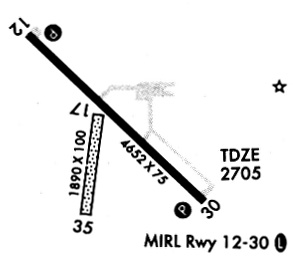
Runways
Runway Summary
| Runways: | 12/30 17/35 |
| Longest Runway: | 12/30 is 4652 ft (1418 m) long |
| Runways with an Instrument Approach: |
KHEI Airport Runway Details
| Runway 12/30 | 4652 ft x 75 ft (1418 m x 23 m) | |
| Runway Length Source: | 3RD PARTY SURVEY as of 08/08/2009 | |
| Surface: | Asphalt - Good condition - No special surface treatment | |
| Runway Edge Lights: | Medium Intensity | |
Runway Weight Bearing Capacity (in thousands of pounds) |
||
| Single Wheel Landing Gear: | 11.5 | |
Runway 12 |
Runway 30 |
|
Elevation: |
2705.3 | 2698.9 |
Latitude: |
46-01-12.9051N | 46-00-40.1035N |
Longitude: |
102-39-43.2754W | 102-38-57.1605W |
|
Runway True Alignment: |
136 | 316 |
Glide Path Angle: |
3.0 degrees | 3.0 degrees |
Traffic Pattern: |
Left | Left |
Runway Markings Type: |
Nonprecision Instrument | Nonprecision Instrument |
Runway Markings Condition: |
Good | Good |
Object at End: |
FENCE | PLINE |
Object Height: |
2 | 41 |
Distance from End: |
250 | 1830 |
Object Centerline Offset: |
250 ft. right of centerline | 495 ft. right of centerline |
Visual Glide Slope Indicators: |
2-Light PAPI On Left Side Of Runway | 2-Light PAPI On Left Side Of Runway |
REIL: |
No | No |
Touchdown Lights: |
No | No |
Centerline Lights: |
No | No |
Threshold Crossing Height: |
25 | 25 |
| Runway 17/35 | 2020 ft x 110 ft (616 m x 34 m) | |
| Runway Length Source: | 3RD PARTY SURVEY as of 08/08/2009 | |
| Surface: | Asphalt - Good condition - No special surface treatment | |
Runway 17 |
Runway 35 |
|
Elevation: |
2702.4 | 2687.6 |
Latitude: |
46-00-56.8337N | 46-00-37.2215N |
Longitude: |
102-39-22.1773W | 102-39-27.2966W |
|
Runway True Alignment: |
190 | 010 |
Glide Path Angle: |
0.0 degrees | 0.0 degrees |
Traffic Pattern: |
Left | Left |
Object at End: |
ACFT | |
Object Height: |
20 | |
Distance from End: |
415 | |
Object Centerline Offset: |
250 ft. right of centerline | 495 ft. right of centerline |
REIL: |
No | No |
Touchdown Lights: |
No | No |
Centerline Lights: |
No | No |
Services
Airframe Repair: |
Minor |
Powerplant Repair: |
Minor |
Bottled Oxygen: |
None |
Bulk Oxygen: |
None |
Fuel Available: |
100LL, Jet A, MOGAS |
Landing Fees: |
No |
Parking: |
Hangars and tiedowns available |
Maps & Diagrams
KHEI Sectional
Flight Planning
at skyvector.com
at skyvector.com