Location
Latitude: |
38-32-29.7800N (38.541606) |
Longitude: |
083-44-38.4670W (-83.744019) |
Elevation: |
913.3 feet MSL (278 m MSL) |
Magnetic Variation: |
6.5 W (as of April 2024 from WMM2020 model) |
Time Zone: |
UTC -5.0 (Standard Time) UTC -4.0 (Daylight Savings Time) |
From City: |
07 N.M. N of Flemingsburg, Kentucky |
Found On: |
Cincinnati Chart |
FAA Region: |
ASO |
Contacts
Manager: |
Publicly owned: |
| DERON MULLIKIN 7079 AIRPORT RD. MAYSVILLE, KY 41056 606-742-2411 |
FLEMING-MASON ARPT BOARD PO BOX 460,, POB 460 MAYSVILLE, KY 41056 (606) 407-2966 |
Operations
Airport Status: |
Operational |
Facility Use: |
Public |
Type: |
Airport |
Activation Date: |
02/1972 |
Control tower: |
No |
Attendance (Months/Days/Hours): |
Months/Days/Hours ALL/MON-FRI/0800-1700 |
Boundary ARTCC: |
ZID (Indianapolis) |
Responsible ARTCC: |
ZID (Indianapolis) |
Lighting Schedule: |
SEE RMK |
Segmented Circle Indicator: |
Yes |
Traffic Pattern Altitude (MSL): |
1913 feet (583 m) |
NOTAMs Facility: |
LOU |
NOTAM-D Service: |
Yes |
International Airport of Entry: |
No |
Customs Landing Rights: |
No |
Military Landing Rights: |
Yes |
Civil/Military Joint Use: |
No |
Based Aircraft
| Single Engine: | 20 |
| GA Helicopters: | 1 |
| Gliders: | 1 |
Annual Operations (as of 06/24/2022)
| Total Operations: | 17070 | |
| GA Local: | 6320 | 37.0% |
| GA Itinerant: | 10500 | 61.5% |
| Military Aircraft: | 250 | 1.5% |
Communications
| CTAF: | 123.000 |
| Unicom: | 123.000 |
| AWOS-3: | 118.125 (606-742-2008) |
- APCH/DEP SVC PRVDD BY INDIANAPOLIS ARTCC ON FREQS 124.225/360.725 (PORTSMOUTH RCAG).
Fixed Based Operators (FBOs) & Fuel
(Click on a business for detail)
Please help us keep this information up to date. This is a FREE SERVICE just like everything else on Airport Guide! If you see that a business needs to be added, modified, or deleted please fill out our Update Form.
To add, modify, or delete a business click here.
Please help us keep this information up to date. This is a FREE SERVICE just like everything else on Airport Guide! If you see that a business needs to be added, modified, or deleted please fill out our Update Form.
Area Code: 606 |
| Business Name | Frequency | Phone | Fuel Grade |
|---|---|---|---|
| Coleman Aviation
Update FBO info |
742-2411 | 80, 100LL, Jet A |
Flight Service Stations
| Primary | Alternate | |
| FSS on Field: | N | |
| FSS Name (ID): | Louisville(LOU) | |
| Frequency: | ||
| Toll Free Phone: | 1-800-WX-BRIEF |
Instrument Procedures / Charts
FAA Terminal Procedures valid from 0901Z 03/21/24 to 0901Z 04/18/24.
There are various types of charts available for an airport. They are listed in the Page Type column. Here is a legend for those types:
APD - Airport Diagram
DP - Departure Procedure Charts
HOT - Hot Spots
IAP - Instrument Approach Procedure Charts
MIN - Minimums
STAR - Standard Terminal Arrival Charts
| Page Type | Page Name | Volume | Action Since Last Cycle |
|---|---|---|---|
| IAP | RNAV (GPS) RWY 07 | SE-1 | |
| IAP | RNAV (GPS) RWY 25 | SE-1 | |
| IAP | VOR/DME-A | SE-1 | |
| MIN | ALTERNATE MINIMUMS | SE-1 | |
| MIN | TAKEOFF MINIMUMS | SE-1 |
Terminal Procedures are only available for airports in several countries with more being added all the time. If you are looking for a specific country's charts, please send an email to support(at)airportguide.com stating the country name. This will be used to prioritize the implementation.
Navigation Aids (Navaids) near KFGX
| Dist (NM) | ID | Morse Code | Name | Type | Freq | True Hdg | Mag Hdg |
|---|---|---|---|---|---|---|---|
| 4.9 | XW | _ . . _ . _ _ | Flmng | NDB | 400 | 67 | 74 |
| 20.6 | AMT | . _ _ _ _ | West Union | NDB | 359 | 24 | 31 |
| 27.3 | FLM | . . _ . . _ . . _ _ | Falmouth | VOR-DME | 117.00 | 283 | 289 |
| 30.0 | PZO | . _ _ . _ _ . . _ _ _ | Peebles | NDB | 329 | 40 | 47 |
| 31.0 | IOB | . . _ _ _ _ . . . | Mount Sterling | NDB | 210 | 201 | 207 |
| 36.4 | YRK | _ . _ _ . _ . _ . _ | York | VORTAC | 112.80 | 80 | 87 |
| 38.9 | PWF | . _ _ . . _ _ . . _ . | Sportys | NDB | 245 | 325 | 331 |
| 39.7 | HOC | . . . . _ _ _ _ . _ . | Hillsboro | NDB | 278 | 13 | 20 |
| 43.8 | GN | _ _ . _ . | Bridl | NDB | 340 | 235 | 241 |
| 45.5 | ECB | . _ . _ . _ . . . | Newcombe | DME | 110.4 | 120 | 127 |
| 46.4 | LUK | . _ . . . . _ _ . _ | Cincinnati | NDB | 335 | 323 | 329 |
| 46.5 | LUK | . _ . . . . _ _ . _ | Cincinnati Muni/Lunken | VOT | 108.40 | 317 | 323 |
| 48.7 | HYK | . . . . _ . _ _ _ . _ | Lexington | VOR-DME | 112.60 | 225 | 231 |
| 48.9 | XYC | _ . . _ _ . _ _ _ . _ . | Seco | NDB | 393 | 196 | 202 |
| 49.1 | HW | . . . . . _ _ | Cubla | NDB | 299 | 352 | 359 |
| 49.9 | MDE | _ _ _ . . . | Madeira | NDB | 379 | 325 | 331 |
| 53.1 | CVG | _ . _ . . . . _ _ _ . | Cincinnati | VORTAC | 117.30 | 302 | 308 |
| 53.4 | MXQ | _ _ _ . . _ _ _ . _ | Midwest | VOR-DME | 112.90 | 357 | 364 |
| 53.4 | EOP | . _ _ _ . _ _ . | Waverly | NDB | 385 | 45 | 52 |
| 54.5 | LE | . _ . . . | Blayd | NDB | 242 | 232 | 238 |
Nearby Airports with Fuel
Notices to Airmen (NOTAMS)
Remarks
| A11 | DAVID MAHER |
| A110-1 | FOR CD CTC INDIANAPOLIS ARTCC AT 317-247-2411. |
| A16 | MANAGER'S CELL (606) 541-2957 |
| A17 | SVC AFT HR - 606-748-7170. |
| A42-07 | MARKINGS FADED. |
| A42-25 | MARKINGS FADED. |
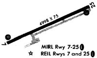
| A81-APT | ACTVT REIL RWY 07 & 25; PAPI RWY 07 & 25; MIRL RWY 07/25 - CTAF. |
Runways
Runway Summary
| Runways: | 07/25 |
| Longest Runway: | 07/25 is 5002 ft (1525 m) long |
| Runways with an Instrument Approach: | 25 |
KFGX Airport Runway Details
| Runway 07/25 | 5002 ft x 100 ft (1525 m x 30 m) | |
| Runway Length Source: | 3RD PARTY SURVEY as of 06/01/2023 | |
| Surface: | Asphalt - Good condition - No special surface treatment | |
| Runway Pavement Class: | 22 /F/C/X/T | |
| Runway Edge Lights: | Medium Intensity | |
Runway Weight Bearing Capacity (in thousands of pounds) |
||
| Single Wheel Landing Gear: | 58.5 | |
| Dual Wheel Landing Gear: | 79.0 | |
Runway 07 |
Runway 25 |
|
Elevation: |
905.0 | 910.7 |
Latitude: |
38-32-20.1954N | 38-32-39.3627N |
Longitude: |
083-45-07.4835W | 083-44-09.4485W |
|
Runway True Alignment: |
067 | 247 |
ILS Type: |
LOCALIZER | |
Glide Path Angle: |
3.0 degrees | 3.0 degrees |
Traffic Pattern: |
Left | Left |
Runway Markings Type: |
Nonprecision Instrument | Nonprecision Instrument |
Runway Markings Condition: |
Poor | Poor |
Object at End: |
TREE | TREE |
Object Height: |
19 | 20 |
Distance from End: |
588 | 299 |
Object Centerline Offset: |
197 ft. left of centerline | 153 ft. left of centerline |
Visual Glide Slope Indicators: |
4-Light PAPI On Right Side Of Runway | 4-Light PAPI On Left Side Of Runway |
REIL: |
Yes | Yes |
Threshold Crossing Height: |
40 | 40 |
Declared Distances |
||
Take Off Run Avbl. (TORA): |
5002 | 5002 |
Take Off Distance Avbl. (TODA): |
5002 | 5002 |
Actual Stop Dist. Avbl. (ASDA): |
5002 | 4703 |
Landing Dist. Avbl. (LDA): |
4703 | 4703 |
Services
Airframe Repair: |
Major |
Powerplant Repair: |
Major |
Bottled Oxygen: |
None |
Bulk Oxygen: |
None |
Fuel Available: |
100LL, Jet A |
Landing Fees: |
No |
Parking: |
Hangars and tiedowns available |
Maps & Diagrams
KFGX Sectional
Flight Planning
at skyvector.com
at skyvector.com