Location
Latitude: |
35-12-09.4430N (35.202623) |
Longitude: |
081-08-59.5530W (-81.149876) |
Elevation: |
797.9 feet MSL (243 m MSL) |
Magnetic Variation: |
7.8 W (as of April 2024 from WMM2020 model) |
Time Zone: |
UTC -5.0 (Standard Time) UTC -4.0 (Daylight Savings Time) |
From City: |
04 N.M. S of Gastonia, North Carolina |
Found On: |
Charlotte Chart |
FAA Region: |
ASO |
Contacts
Manager: |
Publicly owned: |
| STEVE HUSS 1126 GASTON DAY SCHOOL ROAD GASTONIA, NC 28056 704-869-7844 |
CITY OF GASTONIA PO BOX 1748 GASTONIA, NC 28053 (704) 214-9160 |
Operations
Airport Status: |
Operational |
Facility Use: |
Public |
Type: |
Airport |
Control tower: |
No |
Attendance (Months/Days/Hours): |
Months/Days/Hours ALL/MON-SUN/0800-1700 |
Boundary ARTCC: |
ZTL (Atlanta) |
Responsible ARTCC: |
ZTL (Atlanta) |
Lighting Schedule: |
SEE RMK |
Segmented Circle Indicator: |
Yes |
Traffic Pattern Altitude (MSL): |
1798 feet (548 m) |
NOTAMs Facility: |
AKH |
NOTAM-D Service: |
Yes |
International Airport of Entry: |
No |
Customs Landing Rights: |
No |
Military Landing Rights: |
Yes |
Civil/Military Joint Use: |
No |
Based Aircraft
| Single Engine: | 41 |
| Multi Engine: | 5 |
| Jet Engine: | 1 |
| GA Helicopters: | 1 |
Annual Operations (as of 07/04/2022)
| Total Operations: | 9910 | |
| GA Local: | 5400 | 54.5% |
| GA Itinerant: | 4500 | 45.4% |
| Military Aircraft: | 10 | 0.1% |
Communications
| CTAF: | 123.000 |
| Unicom: | 123.000 |
| Approach: | CHARLOTTE |
| Departure: | CHARLOTTE |
| ASOS: | 135.725 (704-868-9034) |
Fixed Based Operators (FBOs) & Fuel
(Click on a business for detail)
Please help us keep this information up to date. This is a FREE SERVICE just like everything else on Airport Guide! If you see that a business needs to be added, modified, or deleted please fill out our Update Form.
To add, modify, or delete a business click here.
Please help us keep this information up to date. This is a FREE SERVICE just like everything else on Airport Guide! If you see that a business needs to be added, modified, or deleted please fill out our Update Form.
Area Code: 704 |
| Business Name | Frequency | Phone | Fuel Grade |
|---|---|---|---|
| City of Gastonia
Update FBO info |
Unicom 123.0 | 864-4363 | 100LL, Jet A |
Flight Service Stations
| Primary | Alternate | |
| FSS on Field: | N | |
| FSS Name (ID): | Raleigh(RDU) | |
| Frequency: | ||
| Toll Free Phone: | 1-800-WX-BRIEF |
Instrument Procedures / Charts
FAA Terminal Procedures valid from 0901Z 03/21/24 to 0901Z 04/18/24.
There are various types of charts available for an airport. They are listed in the Page Type column. Here is a legend for those types:
APD - Airport Diagram
DP - Departure Procedure Charts
HOT - Hot Spots
IAP - Instrument Approach Procedure Charts
MIN - Minimums
STAR - Standard Terminal Arrival Charts
| Page Type | Page Name | Volume | Action Since Last Cycle |
|---|---|---|---|
| DP | BARMY FIVE (RNAV) | SE-2 | Changed |
| DP | BEAVY SIX (RNAV) | SE-2 | Changed |
| DP | BOBZY FIVE (RNAV) | SE-2 | Changed |
| DP | ESTRR FIVE (RNAV) | SE-2 | Changed |
| DP | ICONS FIVE (RNAV) | SE-2 | Changed |
| DP | JOJJO FIVE (RNAV) | SE-2 | Changed |
| DP | KERMIT FOUR | SE-2 | Changed |
| DP | KERMIT FOUR[DELIMITER] CONT.1 | SE-2 | Changed |
| DP | KILNS FIVE (RNAV) | SE-2 | Changed |
| DP | KNIGHTS THREE | SE-2 | Changed |
| DP | KNIGHTS THREE[DELIMITER] CONT.1 | SE-2 | Changed |
| DP | KRITR SIX (RNAV) | SE-2 | Changed |
| DP | KWEEN FIVE (RNAV) | SE-2 | Changed |
| DP | LILLS THREE (RNAV) | SE-2 | Changed |
| DP | WEAZL FIVE (RNAV) | SE-2 | Changed |
| IAP | NDB RWY 03 | SE-2 | |
| IAP | RNAV (GPS) RWY 03 | SE-2 | |
| IAP | RNAV (GPS) RWY 21 | SE-2 | |
| MIN | ALTERNATE MINIMUMS | SE-2 | |
| MIN | TAKEOFF MINIMUMS | SE-2 | |
| STAR | JOOLS ONE (RNAV) | SE-2 | |
| STAR | LIINN THREE | SE-2 | |
| STAR | LIINN THREE[DELIMITER] CONT.1 | SE-2 | |
| STAR | MAJIC FOUR | SE-2 | |
| STAR | RASLN THREE | SE-2 |
Terminal Procedures are only available for airports in several countries with more being added all the time. If you are looking for a specific country's charts, please send an email to support(at)airportguide.com stating the country name. This will be used to prioritize the implementation.
Navigation Aids (Navaids) near KAKH
| Dist (NM) | ID | Morse Code | Name | Type | Freq | True Hdg | Mag Hdg |
|---|---|---|---|---|---|---|---|
| 0.8 | GHJ | _ _ . . . . . . _ _ _ | Stonia | NDB | 260 | 210 | 218 |
| 9.6 | CLT | _ . _ . . _ . . _ | Charlotte | VOT | 112.00 | 81 | 89 |
| 9.7 | CLT | _ . _ . . _ . . _ | Charlotte | VOR-DME | 115.00 | 94 | 102 |
| 19.1 | UZ | . . _ _ _ . . | Rally | NDB | 227 | 169 | 177 |
| 20.3 | IZN | . . _ _ . . _ . | Lincolnton | NDB | 432 | 8 | 16 |
| 22.2 | SLP | . . . . _ . . . _ _ . | First River | NDB | 417 | 277 | 285 |
| 25.1 | DCM | _ . . _ . _ . _ _ | Chester | NDB | 220 | 185 | 193 |
| 26.5 | TWL | _ . _ _ . _ . . | Wesley | NDB | 204 | 124 | 132 |
| 32.1 | LKR | . _ . . _ . _ . _ . | Lancaster | NDB | 400 | 153 | 161 |
| 34.4 | HKY | . . . . _ . _ _ . _ _ | Hickory Regional | VOT | 110.00 | 340 | 348 |
| 35.8 | HK | . . . . _ . _ | Tawba | NDB | 332 | 347 | 355 |
| 39.4 | UOT | . . _ _ _ _ _ | Union County | NDB | 326 | 218 | 226 |
| 39.5 | SPA | . . . . _ _ . . _ | Spartanburg | VORTAC | 115.70 | 255 | 263 |
| 39.7 | FIQ | . . _ . . . _ _ . _ | Fiddlers | NDB | 391 | 320 | 328 |
| 40.2 | BZM | _ . . . _ _ . . _ _ | Barretts Mountain | VOR-DME | 113.75 | 353 | 361 |
| 42.5 | MRN | _ _ . _ . _ . | Lenoir | FAN MARKER | 327 | 335 | |
| 44.8 | FRT | . . _ . . _ . _ | Fairmont | NDB | 248 | 246 | 254 |
| 45.3 | RU | . _ . . . _ | Rovdy | NDB | 275 | 45 | 53 |
| 48.4 | PYG | . _ _ . _ . _ _ _ _ . | Pageland | NDB | 270 | 124 | 132 |
| 53.3 | FDW | . . _ . _ . . . _ _ | Winnsboro | NDB | 414 | 178 | 186 |
Nearby Airports with Fuel
Notices to Airmen (NOTAMS)
Remarks
| A11 | STEVE HUSS. |
| A110-2 | RWY 03 - 15 FT ROAD 292 FT FM THR L & R OF CNTRLN. |
| A110-3 | RWY 21 - 50 FT DROP-OFF 300 FT FM DSPLCD THR L&R OF CNTRLN AND UNMARKED PLINES 370 FT FM DSPLCD THR L&R OF CNTRLN. |
| A110-4 | NOISE ABATEMENT: FROM 2200-0600 PILOTS ARE REQUESTED TO USE RWY 21 AS CALM WIND RWY & DO RUNUPS ON RAMP; NOT RWY END. TO AVOID LOW ALT TURNS TO THE WEST REQ CLNC THRU CLASS B ASP FROM CHARLOTTE APCH. |
| A110-5 | DEER ON & INVOF ARPT. |
| A110-6 | FOR CD CTC CHARLOTTE APCH AT 704-359-0241. |
| A110-7 | RWY 03/21 NO LINE OF SIGHT BTN RWY ENDS. |
| A17 | UNATNDD CHRISTMAS DAY. |
| A17 1 | FOR SERVICE AFTER HOURS CALL 704-201-1500. |
| A57-21 | APCH SLOPE 4:1 TO DSPLCD THR DUE TO 30 FT TREES LOCATED 333 FT FRM DSPLCD THR OFFSET 93 FT RIGHT OF CNTRLN. |
| A81-APT | ACTVT ODALS RWY 03; PAPI RWY 03 & 21; MIRL RWY 03/21 - CTAF. |
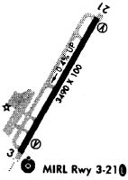
Runways
Runway Summary
| Runways: | 03/21 |
| Longest Runway: | 03/21 is 3769 ft (1149 m) long |
| Runways with an Instrument Approach: |
KAKH Airport Runway Details
| Runway 03/21 | 3769 ft x 100 ft (1149 m x 30 m) | |
| Runway Length Source: | 3RD PARTY SURVEY as of 01/30/2020 | |
| Surface: | Asphalt - Good condition - No special surface treatment | |
| Runway Edge Lights: | Medium Intensity | |
Runway Weight Bearing Capacity (in thousands of pounds) |
||
| Single Wheel Landing Gear: | 24.0 | |
Runway 03 |
Runway 21 |
|
Elevation: |
795.5 | 779.8 |
Latitude: |
35-11-53.0398N | 35-12-25.8468N |
Longitude: |
081-09-10.3290W | 081-08-48.7757W |
|
Runway True Alignment: |
028 | 208 |
Glide Path Angle: |
3.0 degrees | 3.0 degrees |
Traffic Pattern: |
Left | Left |
Runway Markings Type: |
Nonprecision Instrument | Nonprecision Instrument |
Runway Markings Condition: |
Good | Good |
Object at End: |
ROAD | TREES |
Object Height: |
10 | 31 |
Distance from End: |
279 | 255 |
Object Centerline Offset: |
0 ft. left and right of centerline | 90 ft. right of centerline |
Visual Glide Slope Indicators: |
2-Light PAPI On Right Side Of Runway | 2-Light PAPI On Left Side Of Runway |
Approach Light System: |
Omnidirectional Approach Lighting System | |
Touchdown Lights: |
No | No |
Centerline Lights: |
No | No |
Threshold Crossing Height: |
26 | 38 |
Threshold Elevation: |
781.2 | |
Displaced Threshold: |
81 | |
Threshold Latitude: |
35-12-25.1442N | |
Threshold Longitude: |
081-08-49.2349W |
Services
Airframe Repair: |
None |
Powerplant Repair: |
None |
Bottled Oxygen: |
None |
Bulk Oxygen: |
None |
Fuel Available: |
80, 100LL |
Landing Fees: |
No |
Parking: |
Hangars and tiedowns available |
Maps & Diagrams
KAKH Sectional
Flight Planning
at skyvector.com
at skyvector.com