Location
Latitude: |
38-20-39.3050N (38.344251) |
Longitude: |
098-51-33.1090W (-98.859197) |
Elevation: |
1886.7 feet MSL (575 m MSL) |
Magnetic Variation: |
4 E (as of April 2024 from WMM2020 model) |
Time Zone: |
UTC -6.0 (Standard Time) UTC -5.0 (Daylight Savings Time) |
From City: |
04 N.M. W of Great Bend, Kansas |
Found On: |
Wichita Chart |
FAA Region: |
ACE |
Contacts
Manager: |
Publicly owned: |
| MR. MARTIN MILLER CITY HALL, BOX 1168 GREAT BEND, KS 67530 620-793-4168 |
CITY OF GREAT BEND CITY HALL, BOX 1168 GREAT BEND, KS 67530 620-793-4111 |
Operations
Airport Status: |
Operational |
Facility Use: |
Public |
Type: |
Airport |
Activation Date: |
06/1943 |
Control tower: |
No |
Attendance (Months/Days/Hours): |
Months/Days/Hours ALL/ALL/0630-1800 |
Boundary ARTCC: |
ZKC (Kansas City) |
Responsible ARTCC: |
ZKC (Kansas City) |
Lighting Schedule: |
SEE RMK |
Segmented Circle Indicator: |
Yes |
Traffic Pattern Altitude (MSL): |
2887 feet (880 m) |
NOTAMs Facility: |
GBD |
NOTAM-D Service: |
Yes |
International Airport of Entry: |
No |
Customs Landing Rights: |
No |
Military Landing Rights: |
Yes |
Civil/Military Joint Use: |
No |
Based Aircraft
| Single Engine: | 33 |
| Multi Engine: | 4 |
| Jet Engine: | 2 |
| GA Helicopters: | 1 |
| Gliders: | 1 |
Annual Operations (as of 12/31/2022)
| Total Operations: | 8775 | |
| Air Taxi: | 2370 | 27.0% |
| GA Local: | 4178 | 47.6% |
| GA Itinerant: | 2167 | 24.7% |
| Military Aircraft: | 60 | 0.7% |
Communications
| CTAF: | 122.800 |
| Unicom: | 122.800 |
| AWOS-3PT: | 119.275 (620-792-5019) |
- COMMUNICATIONS PRVDD BY WICHITA RADIO ON FREQ 122.5 (GREAT BEND RCO).
- APCH/DEP CTL SVC PRVDD BY KANSAS CITY ARTCC (ZKC) ON FREQS 118.8/322.425 (HUTCHINSON RCAG).
Fixed Based Operators (FBOs) & Fuel
(Click on a business for detail)
Please help us keep this information up to date. This is a FREE SERVICE just like everything else on Airport Guide! If you see that a business needs to be added, modified, or deleted please fill out our Update Form.
To add, modify, or delete a business click here.
Please help us keep this information up to date. This is a FREE SERVICE just like everything else on Airport Guide! If you see that a business needs to be added, modified, or deleted please fill out our Update Form.
Area Code: 620 |
| Business Name | Frequency | Phone | Fuel Grade |
|---|---|---|---|
| Midwest Piper Sales of Great Bend, Inc.
Update FBO info |
Unicom 122.8 | 792-4349 | 100LL, Jet A |
Flight Service Stations
| Primary | Alternate | |
| FSS on Field: | N | |
| FSS Name (ID): | Wichita(ICT) | |
| Frequency: | ||
| Toll Free Phone: | 1-800-WX-BRIEF |
Instrument Procedures / Charts
FAA Terminal Procedures valid from 0901Z 03/21/24 to 0901Z 04/18/24.
There are various types of charts available for an airport. They are listed in the Page Type column. Here is a legend for those types:
APD - Airport Diagram
DP - Departure Procedure Charts
HOT - Hot Spots
IAP - Instrument Approach Procedure Charts
MIN - Minimums
STAR - Standard Terminal Arrival Charts
| Page Type | Page Name | Volume | Action Since Last Cycle |
|---|---|---|---|
| APD | AIRPORT DIAGRAM | NC-2 | |
| IAP | ILS OR LOC RWY 35 | NC-2 | |
| IAP | NDB RWY 35 | NC-2 | |
| IAP | RNAV (GPS) RWY 17 | NC-2 | |
| IAP | RNAV (GPS) RWY 35 | NC-2 | |
| MIN | ALTERNATE MINIMUMS | NC-2 | |
| MIN | TAKEOFF MINIMUMS | NC-2 |
Terminal Procedures are only available for airports in several countries with more being added all the time. If you are looking for a specific country's charts, please send an email to support(at)airportguide.com stating the country name. This will be used to prioritize the implementation.
Navigation Aids (Navaids) near GBD
| Dist (NM) | ID | Morse Code | Name | Type | Freq | True Hdg | Mag Hdg |
|---|---|---|---|---|---|---|---|
| 2.2 | HIL | . . . . . . . _ . . | Hilyn | NDB | 338 | 293 | 289 |
| 5.6 | GB | _ _ . _ . . . | Babsy | NDB | 419 | 178 | 174 |
| 13.7 | LQR | . _ . . _ _ . _ . _ . | Larned | NDB | 296 | 232 | 228 |
| 29.8 | LYO | . _ . . _ . _ _ _ _ _ | Lyons | NDB | 386 | 89 | 85 |
| 31.4 | HY | . . . . _ . _ _ | Nette | NDB | 374 | 324 | 320 |
| 36.0 | HYS | . . . . _ . _ _ . . . | Hays | VORTAC | 110.40 | 327 | 323 |
| 37.5 | PTT | . _ _ . _ _ | Pratt | NDB | 356 | 171 | 167 |
| 45.9 | HU | . . . . . . _ | Saltt | NDB | 404 | 106 | 102 |
| 48.4 | HUT | . . . . . . _ _ | Hutchinson | VOR-DME | 116.80 | 115 | 111 |
| 55.1 | MPR | _ _ . _ _ . . _ . | Mc Pherson | NDB | 227 | 89 | 85 |
| 60.5 | SL | . . . . _ . . | Flory | NDB | 344 | 70 | 66 |
| 61.7 | DDC | _ . . _ . . _ . _ . | Dodge City | VORTAC | 108.20 | 241 | 237 |
| 67.7 | SLN | . . . . _ . . _ . | Salina | VORTAC | 117.10 | 58 | 54 |
| 70.2 | ICT | . . _ . _ . _ | Wichita | VORTAC | 113.80 | 120 | 116 |
| 75.6 | CA | _ . _ . . _ | Harvs | NDB | 395 | 98 | 95 |
| 76.6 | EWK | . . _ _ _ . _ | Newton | NDB | 281 | 102 | 99 |
| 78.3 | ANY | . _ _ . _ . _ _ | Anthony | TACAN | 112.90 | 155 | 151 |
| 79.6 | ICT | . . _ . _ . _ | Wichita | VOT | 114.00 | 121 | 117 |
| 80.7 | IC | . . _ . _ . | Piche | NDB | 332 | 124 | 120 |
| 84.1 | PHG | . _ _ . . . . . _ _ . | Phillipsburg | NDB | 368 | 346 | 342 |
Nearby Airports with Fuel
Notices to Airmen (NOTAMS)
Remarks
| A110-1 | CALM WIND RY DESIGNATED AS RY 17. |
| A110-3 | 100LL AND JET A SELF-SERVE FUEL AVBL N END OF TRML APRON. CALL FBO 620-796-2130 FOR FUEL PRICES. |
| A110-4 | FOR CD IF UNA TO CTC ON FSS FREQ, CTC KANSAS CITY ARTCC AT 913-254-8508. |
| A16 | AIRPORT MGR (620) 792-9446 (CELL). |
| A17 | AFTER 1800 BY REQUEST. |
| A70-FUEL-10 | 0LL 24 HR CREDIT CARD SVC AVBL. |
| A81-APT | ACTVT MALSR RWY 35; REIL RWY 17; PAPI RWY 11, 17 & 29; VASI RWY 35; MIRL 11/29 & 17/35 - CTAF. |
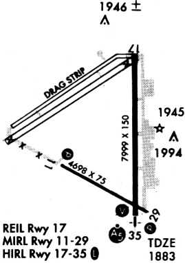
Runways
Runway Summary
| Runways: | 11/29 17/35 |
| Longest Runway: | 17/35 is 7852 ft (2393 m) long |
| Runways with an Instrument Approach: | 35 |
GBD Airport Runway Details
| Runway 11/29 | 4706 ft x 75 ft (1434 m x 23 m) | |
| Runway Length Source: | 3RD PARTY SURVEY as of 04/13/2020 | |
| Surface: | Asphalt - Fair condition - No special surface treatment | |
| Runway Pavement Class: | 9 /R/C/X/U | |
| Runway Edge Lights: | Medium Intensity | |
Runway Weight Bearing Capacity (in thousands of pounds) |
||
| Single Wheel Landing Gear: | 28.0 | |
| Dual Wheel Landing Gear: | 35.0 | |
| Dual Tandem Wheel Landing Gear: | 86.0 | |
Runway 11 |
Runway 29 |
|
Elevation: |
1886.7 | 1882.7 |
Latitude: |
38-20-33.8016N | 38-20-10.8390N |
Longitude: |
098-52-10.4064W | 098-51-19.0467W |
|
Runway True Alignment: |
120 | 300 |
Glide Path Angle: |
3.0 degrees | 3.0 degrees |
Traffic Pattern: |
Left | Left |
Runway Markings Type: |
Nonprecision Instrument | Nonprecision Instrument |
Runway Markings Condition: |
Good | Good |
Visual Glide Slope Indicators: |
4-Light PAPI On Left Side Of Runway | 4-Light PAPI On Left Side Of Runway |
Threshold Crossing Height: |
38 | 43 |
Declared Distances |
||
Take Off Run Avbl. (TORA): |
4706 | 4706 |
Take Off Distance Avbl. (TODA): |
4706 | 4706 |
Actual Stop Dist. Avbl. (ASDA): |
4706 | 4706 |
Landing Dist. Avbl. (LDA): |
4706 | 4706 |
| Runway 17/35 | 7852 ft x 100 ft (2393 m x 30 m) | |
| Runway Length Source: | 3RD PARTY SURVEY as of 04/13/2020 | |
| Surface: | Asphalt - Fair condition - Aggregate friction seal coat | |
| Runway Pavement Class: | 19 /R/C/X/U | |
| Runway Edge Lights: | Medium Intensity | |
Runway Weight Bearing Capacity (in thousands of pounds) |
||
| Single Wheel Landing Gear: | 28.0 | |
| Dual Wheel Landing Gear: | 35.0 | |
| Dual Tandem Wheel Landing Gear: | 86.0 | |
Runway 17 |
Runway 35 |
|
Elevation: |
1881.3 | 1882.5 |
Latitude: |
38-21-28.2888N | 38-20-10.6775N |
Longitude: |
098-51-26.4994W | 098-51-25.7937W |
|
Runway True Alignment: |
180 | 360 |
ILS Type: |
ILS/DME | |
Glide Path Angle: |
3.5 degrees | 3.0 degrees |
Traffic Pattern: |
Left | Left |
Runway Markings Type: |
Nonprecision Instrument | Precision Instrument |
Runway Markings Condition: |
Good | Good |
Visual Glide Slope Indicators: |
4-Light PAPI On Left Side Of Runway | 4-Box VASI On Left Side Of Runway |
Approach Light System: |
1,400 Foot Medium Intensity Approach Lighting System With Runway Alignment Indicator Lights | |
REIL: |
Yes | |
Threshold Crossing Height: |
38 | 50 |
Declared Distances |
||
Take Off Run Avbl. (TORA): |
7852 | 7852 |
Take Off Distance Avbl. (TODA): |
7852 | 7852 |
Actual Stop Dist. Avbl. (ASDA): |
7852 | 7852 |
Landing Dist. Avbl. (LDA): |
7852 | 7852 |
Services
Airframe Repair: |
None |
Powerplant Repair: |
None |
Bottled Oxygen: |
None |
Bulk Oxygen: |
None |
Fuel Available: |
100LL |
Landing Fees: |
No |
Parking: |
Hangars and tiedowns available |
Maps & Diagrams
GBD Sectional
Flight Planning
at skyvector.com
at skyvector.com