Location
Latitude: |
39-50-04.4250N (39.834563) |
Longitude: |
088-51-56.4810W (-88.865689) |
Elevation: |
681.9 feet MSL (208 m MSL) |
Magnetic Variation: |
3 W (as of April 2024 from WMM2020 model) |
Time Zone: |
UTC -6.0 (Standard Time) UTC -5.0 (Daylight Savings Time) |
From City: |
04 N.M. E of Decatur, Illinois |
Found On: |
St Louis Chart |
FAA Region: |
AGL |
Contacts
Manager: |
Publicly owned: |
| TIM A. WRIGHT 910 S. AIRPORT ROAD DECATUR, IL 62521 217-428-2423 |
DECATUR PARK DISTRICT 620 E. RIVERSIDE AVE. DECATUR, IL 62521 217-428-2423 |
Operations
Airport Status: |
Operational |
Facility Use: |
Public |
Type: |
Airport |
Activation Date: |
03/1945 |
Control tower: |
Yes |
Attendance (Months/Days/Hours): |
Months/Days/Hours ALL/MON-FRI/ALL |
Boundary ARTCC: |
ZKC (Kansas City) |
Responsible ARTCC: |
ZAU (Chicago) |
Lighting Schedule: |
SEE RMK |
Segmented Circle Indicator: |
No |
Traffic Pattern Altitude (MSL): |
1682 feet (513 m) |
NOTAMs Facility: |
DEC |
NOTAM-D Service: |
Yes |
International Airport of Entry: |
No |
Customs Landing Rights: |
No |
Military Landing Rights: |
Yes |
Civil/Military Joint Use: |
No |
Aircraft Rescue and Firefighting: |
Class I ARFF Index: A Air Carrier Service: Scheduled Certification Date: 05/1973 |
Based Aircraft
| Single Engine: | 38 |
| Multi Engine: | 1 |
| Military Aircraft: | 12 |
Annual Operations (as of 12/31/2022)
| Total Operations: | 25852 | |
| Commercial: | 1984 | 7.7% |
| Air Taxi: | 855 | 3.3% |
| GA Local: | 11174 | 43.2% |
| GA Itinerant: | 10373 | 40.1% |
| Military Aircraft: | 1466 | 5.7% |
Communications
| CTAF: | 118.900 |
| Unicom: | 122.950 |
| Tower: | DECATUR 118.9 291.775 Hrs: 0600-2200 |
| Ground: | 121.75 291.775 |
| Approach: | CHAMPAIGN 132.85 132.85 CHICAGO ARTCC |
| Departure: | CHAMPAIGN 132.85 132.85 CHICAGO ARTCC |
| ATIS: | 126.35 Hrs: 24 |
| ASOS: | (217-429-0052) |
- APCH/DEP SVC PRVDD BY CHICAGO ARTCC ON REMOTED CHAMPAIGN APCH CTL FREQS 121.35 & 353.95 (DANVILLE RCAG) WHEN CHAMPAIGN APCH CTL CLSD.
Fixed Based Operators (FBOs) & Fuel
(Click on a business for detail)
Please help us keep this information up to date. This is a FREE SERVICE just like everything else on Airport Guide! If you see that a business needs to be added, modified, or deleted please fill out our Update Form.
To add, modify, or delete a business click here.
Please help us keep this information up to date. This is a FREE SERVICE just like everything else on Airport Guide! If you see that a business needs to be added, modified, or deleted please fill out our Update Form.
Area Code: 217 |
| Business Name | Frequency | Phone | Fuel Grade |
|---|---|---|---|
| Decatur Aviation, Inc.
Update FBO info |
Unicom 122.95 | 423-9832 | 100LL, Jet A |
Flight Service Stations
| Primary | Alternate | |
| FSS on Field: | ||
| FSS Name (ID): | Saint Louis(STL) | |
| Frequency: | ||
| Toll Free Phone: | 1-800-WX-BRIEF |
Instrument Procedures / Charts
FAA Terminal Procedures valid from 0901Z 03/21/24 to 0901Z 04/18/24.
There are various types of charts available for an airport. They are listed in the Page Type column. Here is a legend for those types:
APD - Airport Diagram
DP - Departure Procedure Charts
HOT - Hot Spots
IAP - Instrument Approach Procedure Charts
MIN - Minimums
STAR - Standard Terminal Arrival Charts
| Page Type | Page Name | Volume | Action Since Last Cycle |
|---|---|---|---|
| APD | AIRPORT DIAGRAM | EC-3 | |
| IAP | ILS OR LOC RWY 06 | EC-3 | |
| IAP | LOC BC RWY 24 | EC-3 | |
| IAP | RNAV (GPS) RWY 06 | EC-3 | Changed |
| IAP | RNAV (GPS) RWY 12 | EC-3 | |
| IAP | RNAV (GPS) RWY 18 | EC-3 | |
| IAP | RNAV (GPS) RWY 24 | EC-3 | |
| IAP | RNAV (GPS) RWY 30 | EC-3 | |
| IAP | RNAV (GPS) RWY 36 | EC-3 | |
| IAP | VOR RWY 18 | EC-3 | |
| IAP | VOR RWY 36 | EC-3 | |
| LAH | LAHSO | EC-3 | |
| MIN | ALTERNATE MINIMUMS | EC-3 | |
| MIN | TAKEOFF MINIMUMS | EC-3 |
Terminal Procedures are only available for airports in several countries with more being added all the time. If you are looking for a specific country's charts, please send an email to support(at)airportguide.com stating the country name. This will be used to prioritize the implementation.
Navigation Aids (Navaids) near DEC
| Dist (NM) | ID | Morse Code | Name | Type | Freq | True Hdg | Mag Hdg |
|---|---|---|---|---|---|---|---|
| 4.8 | DE | _ . . . | Elwin | NDB | 275 | 236 | 239 |
| 5.3 | DEC | _ . . . _ . _ . | Akley | FAN MARKER | 61 | 64 | |
| 5.8 | AXC | . _ _ . . _ _ . _ . | Adders | VORTAC | 117.20 | 175 | 178 |
| 25.7 | SYZ | . . . _ . _ _ _ _ . . | Shelbyville | NDB | 365 | 177 | 180 |
| 27.7 | TAZ | _ . _ _ _ . . | Taylorville | NDB | 395 | 229 | 232 |
| 29.2 | AAA | . _ . _ . _ | Abraham | NDB | 329 | 312 | 315 |
| 29.7 | CMI | _ . _ . _ _ . . | Champaign | VORTAC | 110.00 | 65 | 68 |
| 32.4 | CM | _ . _ . _ _ | Veals | NDB | 407 | 75 | 78 |
| 33.6 | CJ | _ . _ . . _ _ _ | Calde | NDB | 240 | 266 | 269 |
| 34.3 | MTO | _ _ _ _ _ _ | Mattoon | DME | 109.4 | 128 | 131 |
| 34.3 | LQ | . _ . . _ _ . _ | Licol | NDB | 375 | 278 | 281 |
| 37.4 | SPI | . . . . _ _ . . . | Spinner | VORTAC | 112.70 | 270 | 273 |
| 38.9 | BMI | _ . . . _ _ . . | Bloomington | DME | 108.2 | 355 | 358 |
| 39.7 | MT | _ _ _ | Zebre | NDB | 347 | 126 | 129 |
| 41.4 | SP | . . . . _ _ . | Huskk | NDB | 382 | 265 | 268 |
| 43.5 | HMJ | . . . . _ _ . _ _ _ | Homer | NDB | 281 | 74 | 77 |
| 43.6 | LH | . _ . . . . . . | Egrow | NDB | 334 | 359 | 362 |
| 46.5 | VLA | . . . _ . _ . . . _ | Vandalia | VOR-DME | 114.30 | 197 | 200 |
| 51.0 | CZB | _ . _ . _ _ . . _ . . . | Casey | NDB | 359 | 128 | 131 |
| 55.2 | RBS | . _ . _ . . . . . . | Roberts | VOR-DME | 116.80 | 35 | 38 |
Nearby Airports with Fuel
Notices to Airmen (NOTAMS)
Remarks
| A110-1 | N RAMP FROM HNGR B TO HNGR G CLSD TO ACFT OVR 12500 LBS. |
| A110-2 | WHEN ATCT CLSD BE ALERT FOR VEHICULAR TFC IN ARPT OPS AREAS. |
| A110-3 | BIRDS & WILDLIFE ON & INVOF ARPT. |
| A110-4 | GLIDER OPS RWY 06 & 30 ONLY, RQR WRITTEN APVL - CTC AMGR. SOD OPS NA. |
| A110-5 | SNOW REMOVAL OPS WINTER MONTHS MNT CTAF. LNDG/DEP ACFT USE CTAF WHEN ATCT CLSD. |
| A110-6 | FOR US CUSTOMS CALL 217-425-4803. |
| A110-7 | RWY 12 & 18 AND RWY 06 & 36 CLOSELY ALIGNED. VFY CORRECT RWY AND COMPASS HDG PRIOR TO DEP. |
| A110-8 | TWY A RSTRD NORTH OF TWY G TO ACFT WITH WINGSPAN OF 86FT OR LESS WITHOUT PPR - CTC AMGR. |
| A110-9 | FOR CD IF UNA TO CTC ON FSS FREQ, CTC CHICAGO ARTCC 630-906-8921. |
| A110-10 | (LAHSO_ALD, RWY 24) SECONDARY LAHSO 8000 FT HOLD SHORT OF RWY 18/36. |
| A110-11 | (CONTACT TITLE) 217-428-8836 |
| A26 | INDEX B ARFF CAPABILITY RQR 24 HR PPR - CTC AMGR. |
| A81-APT | ACTVT MALSR RWY 06; REIL RWY 36; MIRL RWY 12/30 & 18/36; TWY LGTS RWY 06 - CTAF. WHEN ATCT CLSD HIRL RWY 06/24 PRESET LOW INTST; INCR INTST - CTAF. |
| E80 | US CUSTOMS USER FEE ARPT. |
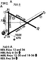
Runways
Runway Summary
| Runways: | 06/24 12/30 18/36 |
| Longest Runway: | 06/24 is 8496 ft (2590 m) long |
| Runways with an Instrument Approach: | 06 |
DEC Airport Runway Details
| Runway 06/24 | 8496 ft x 150 ft (2590 m x 46 m) | |
| Runway Length Source: | 3RD PARTY SURVEY as of 06/22/2010 | |
| Surface: | Asphalt/Concrete - Good condition - Saw-cut or plastic grooved | |
| Runway Pavement Class: | 60 /F/C/X/U | |
| Runway Edge Lights: | High Intensity | |
Runway Weight Bearing Capacity (in thousands of pounds) |
||
| Single Wheel Landing Gear: | 75.0 | |
| Dual Wheel Landing Gear: | 200.0 | |
| Dual Tandem Wheel Landing Gear: | 245.0 | |
Runway 06 |
Runway 24 |
|
Elevation: |
672.7 | 681.8 |
Latitude: |
39-49-37.5532N | 39-50-20.6248N |
Longitude: |
088-52-28.2600W | 088-50-54.7866W |
|
Runway True Alignment: |
059 | 239 |
ILS Type: |
ILS/DME | |
Glide Path Angle: |
0.0 degrees | 3.0 degrees |
Traffic Pattern: |
Left | Left |
Runway Markings Type: |
Precision Instrument | Precision Instrument |
Runway Markings Condition: |
Good | Fair |
Object at End: |
ROAD | |
Object Height: |
17 | |
Distance from End: |
885 | |
Object Centerline Offset: |
599 ft. left of centerline | |
Visual Glide Slope Indicators: |
4-Box VASI On Left Side Of Runway | |
Runway Visual Range (RVR): |
Touchdown, Midfield | Midfield, Rollout |
Approach Light System: |
1,400 Foot Medium Intensity Approach Lighting System With Runway Alignment Indicator Lights | |
REIL: |
No | No |
Touchdown Lights: |
No | No |
Centerline Lights: |
No | No |
Threshold Crossing Height: |
52 | |
Declared Distances |
||
Take Off Run Avbl. (TORA): |
8496 | 8496 |
Take Off Distance Avbl. (TODA): |
8496 | 8496 |
Actual Stop Dist. Avbl. (ASDA): |
8496 | 8496 |
Landing Dist. Avbl. (LDA): |
8496 | 8496 |
| Runway 12/30 | 6799 ft x 150 ft (2072 m x 46 m) | |
| Runway Length Source: | 3RD PARTY SURVEY as of 06/22/2010 | |
| Surface: | Asphalt/Concrete - Good condition - Saw-cut or plastic grooved | |
| Runway Pavement Class: | 60 /F/C/X/U | |
| Runway Edge Lights: | Medium Intensity | |
Runway Weight Bearing Capacity (in thousands of pounds) |
||
| Single Wheel Landing Gear: | 75.0 | |
| Dual Wheel Landing Gear: | 200.0 | |
| Dual Tandem Wheel Landing Gear: | 245.0 | |
Runway 12 |
Runway 30 |
|
Elevation: |
678.3 | 678.0 |
Latitude: |
39-50-28.5038N | 39-49-55.7933N |
Longitude: |
088-52-29.2821W | 088-51-13.1499W |
|
Runway True Alignment: |
119 | 299 |
Glide Path Angle: |
0.0 degrees | 3.0 degrees |
Traffic Pattern: |
Left | Left |
Runway Markings Type: |
Nonprecision Instrument | Nonprecision Instrument |
Runway Markings Condition: |
Good | Fair |
Object at End: |
TREE | |
Object Height: |
43 | |
Distance from End: |
1174 | |
Object Centerline Offset: |
599 ft. left of centerline | |
Visual Glide Slope Indicators: |
4-Light PAPI On Left Side Of Runway | |
REIL: |
No | |
Touchdown Lights: |
No | No |
Centerline Lights: |
No | No |
Threshold Crossing Height: |
51 | |
Declared Distances |
||
Take Off Run Avbl. (TORA): |
6799 | 6799 |
Take Off Distance Avbl. (TODA): |
6799 | 6799 |
Actual Stop Dist. Avbl. (ASDA): |
6799 | 6799 |
Landing Dist. Avbl. (LDA): |
6799 | 6799 |
| Runway 18/36 | 5298 ft x 150 ft (1615 m x 46 m) | |
| Runway Length Source: | 3RD PARTY SURVEY as of 06/22/2010 | |
| Surface: | Asphalt/Concrete - Good condition - Saw-cut or plastic grooved | |
| Runway Pavement Class: | 23 /F/C/X/U | |
| Runway Edge Lights: | Medium Intensity | |
Runway Weight Bearing Capacity (in thousands of pounds) |
||
| Single Wheel Landing Gear: | 75.0 | |
| Dual Wheel Landing Gear: | 115.0 | |
| Dual Tandem Wheel Landing Gear: | 180.0 | |
Runway 18 |
Runway 36 |
|
Elevation: |
678.9 | 672.2 |
Latitude: |
39-50-29.2237N | 39-49-36.8721N |
Longitude: |
088-52-27.7426W | 088-52-26.7004W |
|
Runway True Alignment: |
179 | 359 |
Glide Path Angle: |
3.0 degrees | 3.0 degrees |
Traffic Pattern: |
Left | Left |
Runway Markings Type: |
Nonprecision Instrument | Nonprecision Instrument |
Runway Markings Condition: |
Good | Good |
Object at End: |
TREES | POLE |
Object Height: |
55 | 50 |
Distance from End: |
1755 | 2344 |
Object Centerline Offset: |
599 ft. left of centerline | |
Visual Glide Slope Indicators: |
4-Light PAPI On Left Side Of Runway | 4-Box VASI On Left Side Of Runway |
REIL: |
Yes | |
Touchdown Lights: |
No | No |
Centerline Lights: |
No | No |
Threshold Crossing Height: |
53 | 58 |
Declared Distances |
||
Take Off Run Avbl. (TORA): |
5298 | 5298 |
Take Off Distance Avbl. (TODA): |
5298 | 5298 |
Actual Stop Dist. Avbl. (ASDA): |
5298 | 5298 |
Landing Dist. Avbl. (LDA): |
5298 | 5298 |
Services
Airframe Repair: |
None |
Powerplant Repair: |
None |
Bottled Oxygen: |
None |
Bulk Oxygen: |
None |
Fuel Available: |
100LL, Jet A |
Landing Fees: |
No |
Parking: |
Hangars and tiedowns available |
Maps & Diagrams
DEC Sectional
Flight Planning
at skyvector.com
at skyvector.com