Location
Latitude: |
27-46-19.9000N (27.772194) |
Longitude: |
097-30-08.7000W (-97.502417) |
Elevation: |
46.1 feet MSL (14 m MSL) |
Magnetic Variation: |
3.1 E (as of April 2024 from WMM2020 model) |
Time Zone: |
UTC -6.0 (Standard Time) UTC -5.0 (Daylight Savings Time) |
From City: |
05 N.M. W of Corpus Christi, Texas |
Found On: |
Brownsville Chart |
FAA Region: |
ASW |
Contacts
Manager: |
Publicly owned: |
| KEVIN SMITH 1000 INTERNATIONAL DR CORPUS CHRISTI, TX 78406 361-289-0171 |
CITY OF CORPUS CHRISTI 1201 LEOPARD ST CORPUS CHRISTI, TX 78401-2825 361-880-3220 |
Operations
Airport Status: |
Operational |
Facility Use: |
Public |
Type: |
Airport |
Activation Date: |
07/1960 |
Control tower: |
Yes |
Attendance (Months/Days/Hours): |
Months/Days/Hours ALL/ALL/ALL |
Boundary ARTCC: |
ZHU (Houston) |
Responsible ARTCC: |
ZHU (Houston) |
Lighting Schedule: |
SS-SR |
Segmented Circle Indicator: |
Yes |
Traffic Pattern Altitude (MSL): |
1046 feet (319 m) |
NOTAMs Facility: |
CRP |
NOTAM-D Service: |
Yes |
International Airport of Entry: |
No |
Customs Landing Rights: |
Yes |
Military Landing Rights: |
Yes |
Civil/Military Joint Use: |
No |
Aircraft Rescue and Firefighting: |
Class I ARFF Index: B Air Carrier Service: Scheduled Certification Date: 05/1973 |
Based Aircraft
| Single Engine: | 25 |
| Multi Engine: | 15 |
| Jet Engine: | 8 |
| Military Aircraft: | 6 |
Annual Operations (as of 06/30/2023)
| Total Operations: | 84823 | |
| Commercial: | 7337 | 8.6% |
| Air Taxi: | 8221 | 9.7% |
| GA Local: | 684 | 0.8% |
| GA Itinerant: | 13082 | 15.4% |
| Military Aircraft: | 55499 | 65.4% |
Communications
| Unicom: | 122.950 |
| Tower: | CORPUS 119.4 257.8 Hrs: 24 |
| Clearance Del.: | 118.55 |
| Ground: | 121.9 269.15 |
| Approach: | CORPUS 120.9 ;RWY 13, 18, 340-045 120.9 ;RWY 31, 36, 270-045 124.8 ;RWY 13, 18, 150-339 124.8 ;RWY 31, 36, 150-269 125.4 ;046-149 273.45 ;RWY 13, 18, 150-339 273.45 ;RWY 31, 36, 150-269 307.9 ;046-149 348.725 ;RWY 13, 18, 340-045 348.725 ;RWY 31, 36, 270-045 Hrs: 24 233.7 |
| Departure: | CORPUS 120.9 ;RWY 13, 18, 340-045 120.9 ;RWY 31, 36, 270-045 124.8 ;RWY 13, 18, 150-339 124.8 ;RWY 31, 36, 150-269 125.4 ;046-149 273.45 ;RWY 13, 18, 150-339 273.45 ;RWY 31, 36, 150-269 307.9 ;046-149 348.725 ;RWY 13, 18, 340-045 348.725 ;RWY 31, 36, 270-045 Hrs: 24 233.7 |
| ATIS: | 126.8 Hrs: 24 |
| ASOS: | (361-289-0191) |
| CLASS C: | 124.8 ;RWY 13, 18, 150-339 |
| CLASS C: | 348.725 ;RWY 13, 18, 340-045 |
| CLASS C: | 124.8 ;RWY 31, 36, 150-269 |
| CLASS C: | 120.9 ;RWY 13, 18, 340-045 |
| CLASS C: | 273.45 ;RWY 13, 18, 150-339 |
| CLASS C: | 348.725 ;RWY 31, 36, 270-045 |
| CLASS C: | 125.4 ;046-149 |
| CLASS C: | 120.9 ;RWY 31, 36, 270-045 |
| CLASS C: | 273.45 ;RWY 31, 36, 150-269 |
| EMERG: | 121.5 |
| CG OPS: | 157.175 |
| CLASS C: | 307.9 ;046-149 |
| EMERG: | 243.0 |
| CG OPS: | 345.0 |
- CORPUS CHRISTI INTL TRACON HAS TWO APCH/DEP CALLS.
- COMMUNICATIONS AVAILABLE ON THE GROUND THRU ALICE FSS ON FREQ 122.65.
Fixed Based Operators (FBOs) & Fuel
(Click on a business for detail)
Please help us keep this information up to date. This is a FREE SERVICE just like everything else on Airport Guide! If you see that a business needs to be added, modified, or deleted please fill out our Update Form.
To add, modify, or delete a business click here.
Please help us keep this information up to date. This is a FREE SERVICE just like everything else on Airport Guide! If you see that a business needs to be added, modified, or deleted please fill out our Update Form.
Area Code: 361 |
| Business Name | Frequency | Phone | Fuel Grade |
|---|---|---|---|
| Mercury Air Center
Update FBO info |
Unicom 122.95, Arinc 131.6 | 289-1881 | 100LL, Jet A |
| Signature Flight Support
Website Update FBO info |
Unicom 122.95, Arinc 130.875 | +1 361 289 0585 | 100LL, Jet A |
Flight Service Stations
| Primary | Alternate | |
| FSS on Field: | N | |
| FSS Name (ID): | San Angelo(SJT) | |
| Frequency: | ||
| Toll Free Phone: | 1-800-WX-BRIEF |
Instrument Procedures / Charts
FAA Terminal Procedures valid from 0901Z 03/21/24 to 0901Z 04/18/24.
There are various types of charts available for an airport. They are listed in the Page Type column. Here is a legend for those types:
APD - Airport Diagram
DP - Departure Procedure Charts
HOT - Hot Spots
IAP - Instrument Approach Procedure Charts
MIN - Minimums
STAR - Standard Terminal Arrival Charts
| Page Type | Page Name | Volume | Action Since Last Cycle |
|---|---|---|---|
| APD | AIRPORT DIAGRAM | SC-3 | |
| IAP | ILS OR LOC RWY 13 | SC-3 | |
| IAP | ILS OR LOC RWY 36 | SC-3 | |
| IAP | LOC RWY 31 | SC-3 | |
| IAP | RNAV (GPS) RWY 18 | SC-3 | |
| IAP | RNAV (GPS) X RWY 31 | SC-3 | |
| IAP | RNAV (GPS) Y RWY 13 | SC-3 | |
| IAP | RNAV (GPS) Y RWY 31 | SC-3 | |
| IAP | RNAV (GPS) Y RWY 36 | SC-3 | |
| IAP | RNAV (RNP) Z RWY 13 | SC-3 | |
| IAP | RNAV (RNP) Z RWY 31 | SC-3 | |
| IAP | RNAV (RNP) Z RWY 36 | SC-3 | |
| IAP | VOR OR TACAN RWY 18 | SC-3 | |
| MIN | ALTERNATE MINIMUMS | SC-3 | |
| MIN | TAKEOFF MINIMUMS | SC-3 |
Terminal Procedures are only available for airports in several countries with more being added all the time. If you are looking for a specific country's charts, please send an email to support(at)airportguide.com stating the country name. This will be used to prioritize the implementation.
Navigation Aids (Navaids) near CRP
| Dist (NM) | ID | Morse Code | Name | Type | Freq | True Hdg | Mag Hdg |
|---|---|---|---|---|---|---|---|
| 8.5 | CRP | _ . _ . . _ . . _ _ . | Corpus Christi | VORTAC | 115.50 | 21 | 18 |
| 12.2 | NGP | _ . _ _ . . _ _ . | Truax | TACAN | 114.00 | 114 | 111 |
| 23.0 | NQI | _ . _ _ . _ . . | Kingsville | TACAN | 117.80 | 224 | 221 |
| 27.6 | ALI | . _ . _ . . . . | Alice | VOR | 114.50 | 266 | 263 |
| 29.6 | NOG | _ . _ _ _ _ _ . | Orange Grove | TACAN | 133.60 | 284 | 281 |
| 32.6 | TKB | _ _ . _ _ . . . | Kleberg County | NDB | 347 | 252 | 249 |
| 34.3 | MNO | _ _ _ . _ _ _ | Mellon Ranch | NDB | 375 | 27 | 24 |
| 47.3 | BKS | _ . . . _ . _ . . . | Brooks County | NDB | 353 | 224 | 221 |
| 55.8 | THX | _ . . . . _ . . _ | Three Rivers | VORTAC | 111.40 | 322 | 319 |
| 70.7 | HBV | . . . . _ . . . . . . _ | Hebbronville | NDB | 266 | 249 | 246 |
| 73.1 | VCT | . . . _ _ . _ . _ | Victoria | VOR-DME | 109.00 | 22 | 19 |
| 84.8 | SNE | . . . _ . . | Santa Elena | NDB | 260 | 222 | 219 |
| 86.8 | PSX | . _ _ . . . . _ . . _ | Palacios | VORTAC | 117.30 | 46 | 43 |
| 88.4 | HR | . . . . . _ . | Sebas | NDB | 338 | 185 | 182 |
| 92.9 | HRL | . . . . . _ . . _ . . | Harlingen | VOR-DME | 113.65 | 184 | 181 |
| 94.4 | OKT | _ _ _ _ . _ _ | Yoakum | NDB | 350 | 11 | 8 |
| 95.0 | COT | _ . _ . _ _ _ _ | Cotulla | VORTAC | 115.80 | 296 | 293 |
Nearby Airports with Fuel
Notices to Airmen (NOTAMS)
Remarks
| A110-1 | CABANISS FIELD LCTD 5 MILES SE OF ARPT MAY BE MISTAKEN FOR CORPUS CHRISTI INTL ARPT. VFR TFC MAY BE OPERATING IN THE CABANISS FIELD TFC PATTERN. |
| A110-2 | BIRDS ON & INVOF ARPT YEAR ROUND. |
| A110-4 | CUDDIHY FIELD (CLSD ARPT) IS LCTD 4 MILES SOUTH OF ARPT MAY BE MISTAKEN FOR CORPUS CHRISTI INTL ARPT. |
| A110-5 | ACFT AT TRML GATES ADZ GND CTL PRIOR TO PUSH. |
| A110-6 | UNMANNED ACFT MAY BE OPRG 3 MI WEST OF ARPT DRG DALGT HRS AT OR BLW 400 FT AGL. |
| A110-7 | CG - OFFL BUS, MIN 24 HR PPR. CTC CORPUS CHRISTI AIR 345.0 15 MIN PRIOR TO ENTERING CG RAMP. NO TRAN QRTS OR GOVT TRANSPORTATION AVBL. IF DESTN CG, INCL CGAS CORPUS CHRISTI IN RMK SEC OF FLT PLAN. SECTOR COMMAND CENTER: C361-939-0450. |
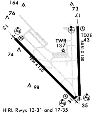
Runways
Runway Summary
| Runways: | 13/31 18/36 |
| Longest Runway: | 13/31 is 7510 ft (2289 m) long |
| Runways with an Instrument Approach: | 13, 31, 36 |
CRP Airport Runway Details
| Runway 13/31 | 7510 ft x 150 ft (2289 m x 46 m) | |
| Runway Length Source: | 3RD PARTY SURVEY as of 03/20/2012 | |
| Surface: | Asphalt - Good condition - Saw-cut or plastic grooved | |
| Runway Edge Lights: | High Intensity | |
Runway Weight Bearing Capacity (in thousands of pounds) |
||
| Single Wheel Landing Gear: | 150.0 | |
| Dual Wheel Landing Gear: | 170.0 | |
| Dual Tandem Wheel Landing Gear: | 245.0 | |
Runway 13 |
Runway 31 |
|
Elevation: |
46.1 | 41.5 |
Latitude: |
27-46-44.3090N | 27-45-50.9886N |
Longitude: |
097-30-55.9790W | 097-29-57.7084W |
|
Runway True Alignment: |
136 | 316 |
ILS Type: |
ILS/DME | LOC/DME |
Glide Path Angle: |
3.0 degrees | 3.0 degrees |
Traffic Pattern: |
Right | Left |
Runway Markings Type: |
Precision Instrument | Precision Instrument |
Runway Markings Condition: |
Good | Good |
Object at End: |
POLE | |
Object Height: |
33 | |
Distance from End: |
1782 | |
Object Centerline Offset: |
640 ft. left of centerline | |
Visual Glide Slope Indicators: |
4-Light PAPI On Left Side Of Runway | 4-Light PAPI On Left Side Of Runway |
Runway Visual Range (RVR): |
Touchdown | |
Approach Light System: |
1,400 Foot Medium Intensity Approach Lighting System With Runway Alignment Indicator Lights | 1,400 Foot Medium Intensity Approach Lighting System With Runway Alignment Indicator Lights |
Threshold Crossing Height: |
50 | 50 |
Declared Distances |
||
Take Off Run Avbl. (TORA): |
7510 | 7510 |
Take Off Distance Avbl. (TODA): |
7510 | 7510 |
Actual Stop Dist. Avbl. (ASDA): |
7510 | 7510 |
Landing Dist. Avbl. (LDA): |
7510 | 7510 |
| Runway 18/36 | 6080 ft x 150 ft (1853 m x 46 m) | |
| Runway Length Source: | FAA as of 05/07/2014 | |
| Surface: | Asphalt - Good condition - Saw-cut or plastic grooved | |
| Runway Edge Lights: | High Intensity | |
Runway Weight Bearing Capacity (in thousands of pounds) |
||
| Single Wheel Landing Gear: | 150.0 | |
| Dual Wheel Landing Gear: | 170.0 | |
| Dual Tandem Wheel Landing Gear: | 245.0 | |
Runway 18 |
Runway 36 |
|
Elevation: |
39.5 | 39.2 |
Latitude: |
27-46-52.6720N | 27-45-52.4755N |
Longitude: |
097-29-46.8800W | 097-29-45.8165W |
|
Runway True Alignment: |
179 | 359 |
ILS Type: |
ILS/DME | |
Glide Path Angle: |
3.0 degrees | 0.0 degrees |
Traffic Pattern: |
Left | Right |
Runway Markings Type: |
Precision Instrument | Precision Instrument |
Runway Markings Condition: |
Good | Good |
Object at End: |
POLE | |
Object Height: |
43 | |
Distance from End: |
1930 | |
Object Centerline Offset: |
640 ft. left of centerline | |
Visual Glide Slope Indicators: |
4-Light PAPI On Left Side Of Runway | |
Runway Visual Range (RVR): |
Touchdown | |
Approach Light System: |
1,400 Foot Medium Intensity Approach Lighting System With Runway Alignment Indicator Lights | 1,400 Foot Medium Intensity Approach Lighting System With Runway Alignment Indicator Lights |
Threshold Crossing Height: |
50 | |
Declared Distances |
||
Take Off Run Avbl. (TORA): |
6080 | 6080 |
Take Off Distance Avbl. (TODA): |
6080 | 6080 |
Actual Stop Dist. Avbl. (ASDA): |
6080 | 6080 |
Landing Dist. Avbl. (LDA): |
6080 | 6080 |
Services
Airframe Repair: |
Minor |
Powerplant Repair: |
Minor |
Bottled Oxygen: |
High Pressure |
Bulk Oxygen: |
None |
Fuel Available: |
100LL, Jet A+ |
Landing Fees: |
No |
Parking: |
Hangars and tiedowns available |
Maps & Diagrams
CRP Sectional
Flight Planning
at skyvector.com
at skyvector.com