Location
Latitude: |
43-57-31.3780N (43.958716) |
Longitude: |
090-44-16.2290W (-90.737841) |
Elevation: |
839.4 feet MSL (256 m MSL) |
Magnetic Variation: |
2 W (as of April 2024 from WMM2020 model) |
Time Zone: |
UTC -6.0 (Standard Time) UTC -5.0 (Daylight Savings Time) |
From City: |
03 N.M. NE of Sparta, Wisconsin |
Found On: |
Chicago Chart |
FAA Region: |
AGL |
Contacts
Manager: |
Army owned: |
| JAMES HUBBARD ATTN:IMMC-PLA FORT MC COY, WI 54656 608-388-4207 |
U S ARMY COMMANDER FORT MC COY, WI 54656 608-388-4207 |
Operations
Airport Status: |
Operational |
Facility Use: |
Public |
Type: |
Airport |
Control tower: |
Yes |
Attendance (Months/Days/Hours): |
Months/Days/Hours ALL/MON-FRI/1400-2200Z++ |
Boundary ARTCC: |
ZAU (Chicago) |
Responsible ARTCC: |
ZAU (Chicago) |
Lighting Schedule: |
SEE RMK |
Segmented Circle Indicator: |
No |
Traffic Pattern Altitude (MSL): |
1839 feet (561 m) |
NOTAMs Facility: |
CMY |
NOTAM-D Service: |
Yes |
Military Landing Rights: |
No |
Civil/Military Joint Use: |
Yes |
Based Aircraft
| Single Engine: | 22 |
| GA Helicopters: | 1 |
Annual Operations (as of 06/22/2022)
| Total Operations: | 6000 | |
| GA Local: | 1500 | 25.0% |
| GA Itinerant: | 1500 | 25.0% |
| Military Aircraft: | 3000 | 50.0% |
Communications
| CTAF: | 124.600 |
| Tower: | SPARTA/MC COY 124.6 254.375 229.4 Hrs: 1400-2200Z++ MON-FRI EXCP FED HOL. |
| Ground: | 123.625 |
| Approach: | VOLK 135.25 135.25 CHICAGO ARTCC |
| Departure: | VOLK 135.25 135.25 CHICAGO ARTCC |
| ASOS: | 119.775 |
| EMERG: | 121.5 |
| RANGE CTL: | 41.35 |
| OPS: | 128.725 ;RANGE INFO |
| RANGE CTL: | 134.1 |
| RANGE CTL: | 245.5 |
| RANGE CTL: | 30.05 |
- APCH/DEP SVC PRVDD BY CHICAGO ARTCC ON FREQS 133.3/257.925 (LONE ROCK RCAG) WHEN VOLK APCH CTL CLSD.
Fixed Based Operators (FBOs) & Fuel
(Click on a business for detail)
Please help us keep this information up to date. This is a FREE SERVICE just like everything else on Airport Guide! If you see that a business needs to be added, modified, or deleted please fill out our Update Form.
To add, modify, or delete a business click here.
Please help us keep this information up to date. This is a FREE SERVICE just like everything else on Airport Guide! If you see that a business needs to be added, modified, or deleted please fill out our Update Form.
Area Code: 608 |
| Business Name | Frequency | Phone | Fuel Grade |
|---|
Flight Service Stations
| Primary | Alternate | |
| FSS on Field: | N | |
| FSS Name (ID): | Green Bay(GRB) | |
| Frequency: | ||
| Toll Free Phone: | 1-800-WX-BRIEF |
Instrument Procedures / Charts
FAA Terminal Procedures valid from 0901Z 03/21/24 to 0901Z 04/18/24.
There are various types of charts available for an airport. They are listed in the Page Type column. Here is a legend for those types:
APD - Airport Diagram
DP - Departure Procedure Charts
HOT - Hot Spots
IAP - Instrument Approach Procedure Charts
MIN - Minimums
STAR - Standard Terminal Arrival Charts
| Page Type | Page Name | Volume | Action Since Last Cycle |
|---|---|---|---|
| APD | AIRPORT DIAGRAM | EC-3 | Changed |
| IAP | NDB RWY 29 | EC-3 | Changed |
| IAP | RNAV (GPS) RWY 11 | EC-3 | Changed |
| IAP | RNAV (GPS) RWY 29 | EC-3 | Changed |
| MIN | ALTERNATE MINIMUMS | EC-3 | |
| MIN | TAKEOFF MINIMUMS | EC-3 |
Terminal Procedures are only available for airports in several countries with more being added all the time. If you are looking for a specific country's charts, please send an email to support(at)airportguide.com stating the country name. This will be used to prioritize the implementation.
Navigation Aids (Navaids) near CMY
| Dist (NM) | ID | Morse Code | Name | Type | Freq | True Hdg | Mag Hdg |
|---|---|---|---|---|---|---|---|
| 4.3 | CMY | _ . _ . _ _ _ . _ _ | Mccoy | NDB | 412 | 106 | 108 |
| 18.4 | BCK | _ . . . _ . _ . _ . _ | Black River Falls | NDB | 362 | 344 | 346 |
| 20.7 | VOK | . . . _ _ _ _ _ . _ | Volk | TACAN | 110.40 | 92 | 94 |
| 22.7 | LS | . _ . . . . . | Mindi | NDB | 272 | 277 | 279 |
| 22.9 | LSE | . _ . . . . . . | La Crosse | DME | 108.4 | 257 | 259 |
| 25.3 | HBW | . . . . _ . . . . _ _ | Kickapoo | NDB | 251 | 135 | 137 |
| 31.6 | ODI | _ _ _ _ . . . . | Nodine | VORTAC | 117.90 | 265 | 267 |
| 37.2 | VIQ | . . . _ . . _ _ . _ | Neillsville | NDB | 368 | 14 | 16 |
| 37.6 | ON | _ _ _ _ . | Bolln | NDB | 264 | 277 | 279 |
| 40.8 | EK | . _ . _ | Nepco | NDB | 326 | 63 | 65 |
| 42.4 | ONA | _ _ _ _ . . _ | Winona | VOR-DME | 111.40 | 279 | 281 |
| 44.4 | DU | _ . . . . _ | Calin | NDB | 266 | 34 | 36 |
| 45.7 | ISW | . . . . . . _ _ | Wisconsin Rapids | NDB | 215 | 57 | 59 |
| 47.2 | MFI | _ _ . . _ . . . | Marshfield | NDB | 391 | 29 | 31 |
| 47.7 | LNR | . _ . . _ . . _ . | Lone Rock | DME | 116.05 | 146 | 148 |
| 48.8 | DLL | _ . . . _ . . . _ . . | Dells | VORTAC | 117.00 | 119 | 121 |
| 53.5 | UKN | . . _ _ . _ _ . | Waukon | DME | 116.6 | 220 | 222 |
| 62.6 | STE | . . . _ . | Stevens Point | VORTAC | 110.60 | 55 | 58 |
| 63.6 | PH | . _ _ . . . . . | Bayye | NDB | 351 | 46 | 48 |
| 64.7 | EAU | . . _ . . _ | Eau Claire | VORTAC | 113.65 | 330 | 332 |
Nearby Airports with Fuel
Notices to Airmen (NOTAMS)
Remarks
| A11 | US ARMY LEASES PART OF ARPT TO CITY OF SPARTA. |
| A110-11 | RWY 01, 11, 29 NSTD SAFETY AREA BYD EACH END DUE TO TERRAIN GRADE AND FENCING. NSTD NORTH LATERAL CLEARANCE RWY 11/29; SEE KCMY AP/1 FOR FURTHER INFORMATION.. |
| A110-13 | EXTSV VFR ASSAULT STRIP TFC EAST OF RY 11/29. |
| A110-14 | INTENSE PARADROP OPS INVOF 3.5 NM EAST-NORTHEAST OF AFLD YEAR ROUND. |
| A110-16 | RSTD: ARFF SVC AVBL UPON REQ WITH 72 HR NTC, INDEX B SVC AVBL H24. 72 HR NTC FOR REQ C608-388-2508, DSN 280-2508. |
| A110-17 | FOR CD WHEN ATCT CLSD CTC CHICAGO ARTCC AT 630-906-8921. |
| A110-2 | OCCASIONAL WILDGAME & BIRDS ON & INVOF ARPT. |
| A110-3 | 24 HR PPR RQRD BY ALL FOR SVC AFTER 2200Z++ AND WKENDS; C608-388-4107 DSN 280-4107, CLSD FEDERAL HOL AND OTHER TIMES BY NOTAM; R/W HOT PIT AVBL TO TRAINED AIRCREWS ONLY. FOR FURTHER FUEL AND TRAINING REQUIREMENTS REFER TO AP1. |
| A110-4 | FICONS NOT MONITORED AFT HRS. |
| A110-5 | SNOW REMOVAL EQUIP OPRS MONITOR CTAF WHEN ATCT CLOSED. |
| A110-6 | SUPPLEMENTARY LGTD WINDCONES RY 11 & 01. |
| A110-7 | RAPIDLY RISING TERRAIN 1 NM NORTHWEST TO NORTHEAST OF ARPT. |
| A110-8 | ACFT C130 AND LRGR, 180 DEG TURNS ALLOWED ONLY ON CONC SFC AT EAST AND WEST ENDS OF RWY 11/29 AND SOUTH END RWY 01/19 CONC SFC. |
| A110-9 | R6901B 500 YDS DEP END RY 11. |
| A14 | CITY OF SPARTA (CIVIL) AMGR MARK VAN VORMER. |
| A17 | EXCP FEDERAL HOLS. |
| A30A-11 | DEP BE ALERT FOR OPTICAL ILLUSION; VEHICLES ON ROAD MAY APPEAR TO BE ON RWY. |
| A30A-19 | CTLD SMALL ARMS RANGE 1000 YDS DEP END RWY. |
| A43-01 | OPR CONSLY. |
| A43-11 | OPR CONSLY. |
| A43-19 | OPR CONSLY. |
| A43-29 | OPR CONSLY. |
| A57-29 | APCH RATIO 34:1 TO DTHR. |
| A58-11 | 10 FT BRUSH 0 - 200 FT FM RWY END, 150-200 FT L. |
| A58-29 | 15 FT ROAD 0-200 FT FM RWY END, 0-107 FT L. |
| A70-FUEL-10 | 0LL SELF SERV H24 WITH CREDIT CARD ON CIVIL RAMP. |
| A70-FUEL-A+ | + MIL FUEL RAMP SELF SVC 24/7 1 APR TO 30 SEP AND H24 MON-FRI 1 OCT TO 31 MAR TO TRAINED MIL KEY HOLDERS; 1 OCT-31 MAR PPR RQRD PRIOR THURS BY 2200Z++ FOR WKEND FUEL OR SVC. |
| A81-APT | WHEN TWR CLSD, MIRL RWY 11/29 PRESET TO LOW SS-SR; TO INCR INTST MIRL RWY 11/29; ACTVT REIL RWY 11 & 29; MIRL RWY 01/19 - CTAF. |
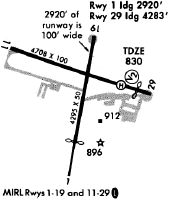
Runways
Runway Summary
| Runways: | 01/19 11/29 |
| Longest Runway: | 11/29 is 4697 ft (1432 m) long |
| Runways with an Instrument Approach: |
CMY Airport Runway Details
| Runway 01/19 | 3032 ft x 95 ft (924 m x 29 m) | |
| Runway Length Source: | MILITARY as of 05/20/2021 | |
| Surface: | Asphalt - Good condition - No special surface treatment | |
| Runway Pavement Class: | 41 /F/A/W/T | |
| Runway Edge Lights: | Medium Intensity | |
Runway 01 |
Runway 19 |
|
Elevation: |
839.4 | 826.5 |
Latitude: |
43-57-10.8500N | 43-57-39.7100N |
Longitude: |
090-44-22.3200W | 090-44-11.3000W |
|
Runway True Alignment: |
015 | 195 |
Glide Path Angle: |
3.5 degrees | 3.5 degrees |
Runway Markings Type: |
Nonprecision Instrument | Nonprecision Instrument |
Runway Markings Condition: |
Good | Good |
Visual Glide Slope Indicators: |
2-Light PAPI On Left Side Of Runway | 2-Light PAPI On Left Side Of Runway |
Threshold Crossing Height: |
46 | 45 |
| Runway 11/29 | 4697 ft x 100 ft (1432 m x 30 m) | |
| Runway Length Source: | 3RD PARTY SURVEY as of 07/31/2019 | |
| Surface: | Asphalt - Good condition - No special surface treatment | |
| Runway Pavement Class: | 54 /R/B/W/T | |
| Runway Edge Lights: | Medium Intensity | |
Runway 11 |
Runway 29 |
|
Elevation: |
821.8 | 831.6 |
Latitude: |
43-57-44.0563N | 43-57-26.5677N |
Longitude: |
090-44-45.5920W | 090-43-46.1183W |
|
Runway True Alignment: |
112 | 292 |
Glide Path Angle: |
3.0 degrees | 3.0 degrees |
Runway Markings Type: |
Nonprecision Instrument | Nonprecision Instrument |
Runway Markings Condition: |
Good | Good |
Object at End: |
TREES | ROAD |
Object Height: |
10 | 15 |
Distance from End: |
231 | 200 |
Visual Glide Slope Indicators: |
4-Light PAPI On Left Side Of Runway | 4-Light PAPI On Left Side Of Runway |
REIL: |
Yes | Yes |
Threshold Crossing Height: |
42 | 43 |
Threshold Elevation: |
831.2 | |
Displaced Threshold: |
431 | |
Threshold Latitude: |
43-57-28.1733N | |
Threshold Longitude: |
090-43-51.5769W |
Services
Fuel Available: |
100LL |
Landing Fees: |
No |
Parking: |
Hangars available |
Maps & Diagrams
CMY Sectional
Flight Planning
at skyvector.com
at skyvector.com