Location
Latitude: |
35-57-51.6000N (35.964333) |
Longitude: |
089-56-38.2000W (-89.943944) |
Elevation: |
254.1 feet MSL (77 m MSL) |
Magnetic Variation: |
1.9 W (as of April 2024 from WMM2020 model) |
Time Zone: |
UTC -6.0 (Standard Time) UTC -5.0 (Daylight Savings Time) |
From City: |
03 N.M. NW of Blytheville, Arkansas |
Found On: |
Memphis Chart |
FAA Region: |
ASW |
Contacts
Manager: |
Publicly owned: |
| TODD RILEY 4701 MEMORIAL DRIVE BLYTHEVILLE, AR 72315 870-532-5628 |
GOSNELL REG AIRPORT AUTHORITY 4701 MEMORIAL DRIVE BLYTHEVILLE, AR 72315-0166 870-532-2100 |
Operations
Airport Status: |
Operational |
Facility Use: |
Public |
Type: |
Airport |
Activation Date: |
10/1943 |
Control tower: |
No |
Attendance (Months/Days/Hours): |
Months/Days/Hours ALL/MON-FRI/0800-1700 |
Boundary ARTCC: |
ZME (Memphis) |
Responsible ARTCC: |
ZME (Memphis) |
Lighting Schedule: |
SEE RMK |
Segmented Circle Indicator: |
Yes |
Traffic Pattern Altitude (MSL): |
1254 feet (382 m) |
NOTAMs Facility: |
BYH |
NOTAM-D Service: |
Yes |
Military Landing Rights: |
Yes |
Civil/Military Joint Use: |
No |
Based Aircraft
| Single Engine: | 7 |
| Multi Engine: | 1 |
| Jet Engine: | 19 |
Annual Operations (as of 09/30/2021)
| Total Operations: | 16000 | |
| GA Local: | 10000 | 62.5% |
| GA Itinerant: | 1000 | 6.2% |
| Military Aircraft: | 5000 | 31.2% |
Communications
| CTAF: | 122.700 |
| Unicom: | 122.700 |
- APCH/DEP SVC PRVDD BY MEMPHIS ARTCC ON FREQS 134.65/316.15 (MCKELLAR RCAG).
Fixed Based Operators (FBOs) & Fuel
(Click on a business for detail)
Please help us keep this information up to date. This is a FREE SERVICE just like everything else on Airport Guide! If you see that a business needs to be added, modified, or deleted please fill out our Update Form.
To add, modify, or delete a business click here.
Please help us keep this information up to date. This is a FREE SERVICE just like everything else on Airport Guide! If you see that a business needs to be added, modified, or deleted please fill out our Update Form.
Area Code: 870 |
| Business Name | Frequency | Phone | Fuel Grade |
|---|
Flight Service Stations
| Primary | Alternate | |
| FSS on Field: | N | |
| FSS Name (ID): | Jonesboro(JBR) | |
| Frequency: | ||
| Toll Free Phone: | 1-800-WX-BRIEF |
Instrument Procedures / Charts
FAA Terminal Procedures valid from 0901Z 03/21/24 to 0901Z 04/18/24.
There are various types of charts available for an airport. They are listed in the Page Type column. Here is a legend for those types:
APD - Airport Diagram
DP - Departure Procedure Charts
HOT - Hot Spots
IAP - Instrument Approach Procedure Charts
MIN - Minimums
STAR - Standard Terminal Arrival Charts
| Page Type | Page Name | Volume | Action Since Last Cycle |
|---|---|---|---|
| IAP | ILS OR LOC RWY 18 | SC-1 | |
| IAP | RNAV (GPS) RWY 18 | SC-1 | |
| IAP | RNAV (GPS) RWY 36 | SC-1 | |
| MIN | TAKEOFF MINIMUMS | SC-1 |
Terminal Procedures are only available for airports in several countries with more being added all the time. If you are looking for a specific country's charts, please send an email to support(at)airportguide.com stating the country name. This will be used to prioritize the implementation.
Navigation Aids (Navaids) near BYH
| Dist (NM) | ID | Morse Code | Name | Type | Freq | True Hdg | Mag Hdg |
|---|---|---|---|---|---|---|---|
| 0.8 | GOJ | _ _ . _ _ _ . _ _ _ | Gosnell | VOR | 111.80 | 170 | 172 |
| 28.4 | COO | _ . _ . _ _ _ _ _ _ | Covington | NDB | 326 | 142 | 144 |
| 30.6 | DYR | _ . . _ . _ _ . _ . | Dyersburg | TACAN | 116.80 | 83 | 85 |
| 31.8 | JBR | . _ _ _ _ . . . . _ . | Jonesboro | VOR-DME | 115.85 | 260 | 262 |
| 35.5 | MAW | _ _ . _ . _ _ | Malden | TACAN | 111.20 | 2 | 4 |
| 41.0 | MIG | _ _ . . _ _ . | Millington | NDB | 232 | 179 | 181 |
| 45.3 | GQE | _ _ . _ _ . _ . | Gilmore | VOR-DME | 113.00 | 215 | 217 |
| 46.1 | SPQ | . . . . _ _ . _ _ . _ | Spain | NDB | 414 | 186 | 188 |
| 46.2 | FD | . . _ . _ . . | Earli | NDB | 278 | 336 | 338 |
| 49.7 | TNZ | _ _ . _ _ . . | Lawrence County | NDB | 227 | 287 | 289 |
| 49.8 | ARG | . _ . _ . _ _ . | Walnut Ridge | VORTAC | 114.50 | 280 | 282 |
| 50.1 | UC | . . _ _ . _ . | Obion | NDB | 212 | 66 | 68 |
| 52.9 | FYE | . . _ . _ . _ _ . | Somerville | NDB | 255 | 149 | 151 |
| 54.5 | ME | _ _ . | Elvis | NDB | 287 | 186 | 188 |
| 54.8 | MKL | _ _ _ . _ . _ . . | Mc Kellar | VOR-DME | 112.00 | 112 | 114 |
| 54.9 | MEM | _ _ . _ _ | Memphis Metropolitn | VOT | 111.00 | 181 | 183 |
| 55.1 | MKL | _ _ _ . _ . _ . . | Mersy | NDB | 394 | 118 | 120 |
| 57.0 | MEM | _ _ . _ _ | Memphis | VORTAC | 117.50 | 181 | 183 |
| 60.0 | CHQ | _ . _ . . . . . _ _ . _ | Charleston | NDB | 208 | 28 | 30 |
| 72.1 | HZD | . . . . _ _ . . _ . . | Huntingdon | NDB | 217 | 83 | 85 |
Nearby Airports with Fuel
Notices to Airmen (NOTAMS)
Remarks
| A110*G | THIS AIRPORT HAS BEEN SURVEYED BY THE NATIONAL GEODETIC SURVEY. |
| A110-1 | NO FEE CHRGD FOR SVC AFT HRS CTC/LV MSG - 870-532-5628. |
| A110-2 | FOR CD CTC MEMPHIS ARTCC AT 901-368-8453/8449. |
| A110-3 | TWY A BTN TWY B AND TWY D TKOF AND LDG AVBL TO MIL ACFT. |
| A17 | ARPT UNATNDD HOLS. |
| A40-18/36 | NSTD HIRL; LCTD 77 FT FM RWY EDGE & NSTD DSTC FM CNTRLN. DPT PRECEPTION PROBLEMS MAY EXIST DURG PDS OF DARKNESS. |
| A43-36 | RY 36 V4L OTS INDEFLY. |
| A70-FUEL-10 | 0LL FUEL AVBL 24 HRS SELF SERVE WITH CREDIT CARD (100 LL) |
| A81-APT | DUSK-DAWN. ACTVT HIRL RY 18/36 - CTAF. |
Runways
Runway Summary
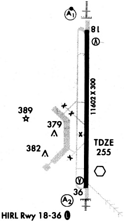
| Runways: | 18/36 |
| Longest Runway: | 18/36 is 11602 ft (3536 m) long |
| Runways with an Instrument Approach: | 18 |
BYH Airport Runway Details
| Runway 18/36 | 11602 ft x 150 ft (3536 m x 46 m) | |
| Runway Length Source: | NGS as of 07/24/2008 | |
| Surface: | Concrete - Good condition - No special surface treatment | |
| Runway Edge Lights: | High Intensity | |
Runway Weight Bearing Capacity (in thousands of pounds) |
||
| Single Wheel Landing Gear: | 155.0 | |
| Dual Wheel Landing Gear: | 235.0 | |
| Dual Tandem Wheel Landing Gear: | 455.0 | |
Runway 18 |
Runway 36 |
|
Elevation: |
250.3 | 252.0 |
Latitude: |
35-58-49.0017N | 35-56-54.2742N |
Longitude: |
089-56-38.2330W | 089-56-38.2376W |
|
Runway True Alignment: |
180 | 360 |
ILS Type: |
ILS/DME | |
Glide Path Angle: |
0.0 degrees | 3.0 degrees |
Traffic Pattern: |
Left | Left |
Runway Markings Type: |
Precision Instrument | Precision Instrument |
Runway Markings Condition: |
Good | Good |
Visual Glide Slope Indicators: |
4-Box VASI On Left Side Of Runway | |
REIL: |
No | No |
Touchdown Lights: |
No | No |
Centerline Lights: |
No | No |
Threshold Crossing Height: |
51 |
Services
Airframe Repair: |
Major |
Powerplant Repair: |
Major |
Bottled Oxygen: |
High Pressure / Low Pressure |
Bulk Oxygen: |
High Pressure / Low Pressure |
Fuel Available: |
100LL, Jet A+ |
Landing Fees: |
No |
Parking: |
Hangars and tiedowns available |
Maps & Diagrams
BYH Sectional
Flight Planning
at skyvector.com
at skyvector.com