Location
Latitude: |
40-07-45.0350N (40.129176) |
Longitude: |
091-40-41.7700W (-91.678269) |
Elevation: |
675.0 feet MSL (206 m MSL) |
Magnetic Variation: |
1 W (as of April 2024 from WMM2020 model) |
Time Zone: |
UTC -6.0 (Standard Time) UTC -5.0 (Daylight Savings Time) |
From City: |
02 N.M. NE of Monticello, Missouri |
Found On: |
Kansas City Chart |
FAA Region: |
ACE |
Contacts
Manager: |
Publicly owned: |
| JESSE ROGERS P.O. BOX 135 CANTON, MO 63435 (660) 216-4801 |
LEWIS COUNTY AIRPORT AUTHORITY PO BOX 85 CANTON, MO 63435 (660) 216-4801 |
Operations
Airport Status: |
Operational |
Facility Use: |
Public |
Type: |
Airport |
Activation Date: |
07/1992 |
Control tower: |
No |
Attendance (Months/Days/Hours): |
Months/Days/Hours Unattended |
Boundary ARTCC: |
ZKC (Kansas City) |
Responsible ARTCC: |
ZKC (Kansas City) |
Lighting Schedule: |
SEE RMK |
Segmented Circle Indicator: |
Yes |
Traffic Pattern Altitude (MSL): |
1675 feet (511 m) |
NOTAMs Facility: |
STL |
NOTAM-D Service: |
Yes |
Based Aircraft
| Single Engine: | 10 |
Annual Operations (as of 12/31/2020)
| Total Operations: | 4255 | |
| GA Local: | 1250 | 29.4% |
| GA Itinerant: | 3000 | 70.5% |
| Military Aircraft: | 5 | 0.1% |
Communications
| CTAF: | 122.700 |
| Unicom: | 122.700 |
- APCH/DEP SVC PRVDD BY KANSAS CITY ARTCC ON FREQS 126.225/317.775 (QUINCY RCAG).
Fixed Based Operators (FBOs) & Fuel
(Click on a business for detail)
Please help us keep this information up to date. This is a FREE SERVICE just like everything else on Airport Guide! If you see that a business needs to be added, modified, or deleted please fill out our Update Form.
To add, modify, or delete a business click here.
Please help us keep this information up to date. This is a FREE SERVICE just like everything else on Airport Guide! If you see that a business needs to be added, modified, or deleted please fill out our Update Form.
Area Code: 573 |
| Business Name | Frequency | Phone | Fuel Grade |
|---|---|---|---|
| Lewis Airport Authority
Update FBO info |
Unicom 122.7 | 767-5323, 288-3218, 655-2214 | 100LL |
Flight Service Stations
| Primary | Alternate | |
| FSS on Field: | ||
| FSS Name (ID): | Saint Louis(STL) | |
| Frequency: | ||
| Toll Free Phone: | 1-800-WX-BRIEF |
Instrument Procedures / Charts
FAA Terminal Procedures valid from 0901Z 03/21/24 to 0901Z 04/18/24.
There are various types of charts available for an airport. They are listed in the Page Type column. Here is a legend for those types:
APD - Airport Diagram
DP - Departure Procedure Charts
HOT - Hot Spots
IAP - Instrument Approach Procedure Charts
MIN - Minimums
STAR - Standard Terminal Arrival Charts
| Page Type | Page Name | Volume | Action Since Last Cycle |
|---|---|---|---|
| IAP | RNAV (GPS) RWY 18 | NC-3 | |
| IAP | RNAV (GPS) RWY 36 | NC-3 | |
| MIN | TAKEOFF MINIMUMS | NC-3 |
Terminal Procedures are only available for airports in several countries with more being added all the time. If you are looking for a specific country's charts, please send an email to support(at)airportguide.com stating the country name. This will be used to prioritize the implementation.
Navigation Aids (Navaids) near 6M6
| Dist (NM) | ID | Morse Code | Name | Type | Freq | True Hdg | Mag Hdg |
|---|---|---|---|---|---|---|---|
| 23.0 | EOK | . _ _ _ _ . _ | Keokuk | NDB | 366 | 29 | 30 |
| 24.3 | UI | . . _ . . | Quincy | NDB | 293 | 126 | 127 |
| 24.9 | UIN | . . _ . . _ . | Quincy | TACAN | 113.60 | 132 | 133 |
| 40.5 | BR | _ . . . . _ . | Burns | NDB | 390 | 38 | 39 |
| 41.9 | IRK | . . . _ . _ . _ | Kirksville | VORTAC | 114.60 | 270 | 271 |
| 46.7 | MCM | _ _ _ . _ . _ _ | Macon | DME | 112.9 | 232 | 233 |
| 49.5 | BRL | _ . . . . _ . . _ . . | Burlington | VOR-DME | 111.40 | 43 | 44 |
| 49.8 | MPZ | _ _ . _ _ . _ _ . . | Mount Pleasant | NDB | 212 | 8 | 9 |
| 50.5 | BEX | _ . . . . _ . . _ | Bloomfield | NDB | 269 | 317 | 318 |
| 54.8 | FFL | . . _ . . . _ . . _ . . | Fairfield | NDB | 332 | 345 | 346 |
| 56.2 | JZY | . _ _ _ _ _ . . _ . _ _ | Macomb | NDB | 251 | 65 | 66 |
| 61.5 | OTM | _ _ _ _ _ _ | Ottumwa | VOR-DME | 111.60 | 331 | 332 |
| 64.4 | HLV | . . . . . _ . . . . . _ | Hallsville | VORTAC | 114.20 | 198 | 199 |
| 69.0 | AWG | . _ . _ _ _ _ . | Washington | NDB | 219 | 0 | 1 |
| 69.4 | BZK | _ . . . _ _ . . _ . _ | Brookfield | NDB | 383 | 252 | 252 |
| 69.5 | IJX | . . . _ _ _ _ . . _ | Jacksonville | DME | 108.6 | 107 | 109 |
| 74.6 | GBG | _ _ . _ . . . _ _ . | Galesburg | DME | 109.8 | 49 | 50 |
| 75.4 | OOA | _ _ _ _ _ _ . _ | Oskaloosa | NDB | 414 | 331 | 332 |
| 77.8 | CTK | _ . _ . _ _ . _ | Canton | NDB | 236 | 69 | 71 |
| 78.0 | DDD | _ . . _ . . _ . . | Port City | DME | 116.5 | 17 | 18 |
Nearby Airports with Fuel
Notices to Airmen (NOTAMS)
Remarks
| A110-1 | ULTRALIGHT ACTIVITY ON & INVOF ARPT. |
| A110-2 | FOR CD CTC KANSAS CITY ARTCC AT 913-254-8508. |
| A14 | CONTACT PERSON - CHAIRMAN ARPT AUTH. |
| A16 | ALTERNATE PHONE NMBRS 660-216-4801, 660-341-0509. |
| A81-APT | ACTVT MIRL RY 18/36 - CTAF. |
| A82 | UNICOM UNMON. |
Runways
Runway Summary
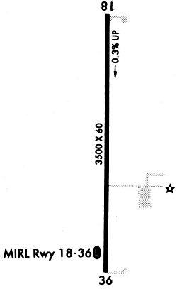
| Runways: | 18/36 |
| Longest Runway: | 18/36 is 3500 ft (1067 m) long |
| Runways with an Instrument Approach: |
6M6 Airport Runway Details
| Runway 18/36 | 3500 ft x 60 ft (1067 m x 18 m) | |
| Runway Length Source: | 3RD PARTY SURVEY as of 04/13/2005 | |
| Surface: | Concrete - Good condition - No special surface treatment | |
| Runway Edge Lights: | Medium Intensity | |
Runway Weight Bearing Capacity (in thousands of pounds) |
||
| Single Wheel Landing Gear: | 30.0 | |
Runway 18 |
Runway 36 |
|
Elevation: |
664.6 | 674.9 |
Latitude: |
40-08-02.3200N | 40-07-27.7500N |
Longitude: |
091-40-41.2200W | 091-40-42.3200W |
|
Runway True Alignment: |
181 | 001 |
Glide Path Angle: |
3.0 degrees | 3.0 degrees |
Traffic Pattern: |
Left | Left |
Runway Markings Type: |
Nonprecision Instrument | Nonprecision Instrument |
Runway Markings Condition: |
Good | Good |
Visual Glide Slope Indicators: |
2-Light PAPI On Left Side Of Runway | 2-Light PAPI On Left Side Of Runway |
REIL: |
No | No |
Threshold Crossing Height: |
40 | 40 |
Services
Fuel Available: |
100LL, MOGAS |
Landing Fees: |
No |
Maps & Diagrams
6M6 Sectional
Flight Planning
at skyvector.com
at skyvector.com