Location
Latitude: |
42-57-47.5300N (42.963203) |
Longitude: |
088-49-03.4610W (-88.817628) |
Elevation: |
799.9 feet MSL (244 m MSL) |
Magnetic Variation: |
3.4 W (as of April 2024 from WMM2020 model) |
Time Zone: |
UTC -6.0 (Standard Time) UTC -5.0 (Daylight Savings Time) |
From City: |
03 N.M. NE of Fort Atkinson, Wisconsin |
Found On: |
Chicago Chart |
FAA Region: |
AGL |
Contacts
Manager: |
Publicly owned: |
| ANDY SELLE 101 N MAIN ST FORT ATKINSON, WI 53538 920-563-7760 |
CITY OF FT. ATKINSON 101 NORTH MAIN ST FORT ATKINSON, WI 53538 920-563-7760 |
Operations
Airport Status: |
Operational |
Facility Use: |
Public |
Type: |
Airport |
Activation Date: |
05/1948 |
Control tower: |
No |
Attendance (Months/Days/Hours): |
Months/Days/Hours Unattended |
Boundary ARTCC: |
ZAU (Chicago) |
Responsible ARTCC: |
ZAU (Chicago) |
Lighting Schedule: |
SEE RMK |
Segmented Circle Indicator: |
Yes |
Traffic Pattern Altitude (MSL): |
1800 feet (549 m) |
NOTAMs Facility: |
GRB |
NOTAM-D Service: |
Yes |
Civil/Military Joint Use: |
No |
Based Aircraft
| Single Engine: | 18 |
| Multi Engine: | 1 |
| GA Helicopters: | 4 |
| Ultralights: | 1 |
Annual Operations (as of 05/24/2021)
| Total Operations: | 10900 | |
| Air Taxi: | 200 | 1.8% |
| GA Local: | 7350 | 67.4% |
| GA Itinerant: | 3300 | 30.3% |
| Military Aircraft: | 50 | 0.5% |
Communications
| CTAF: | 122.900 |
| Approach: | MADISON 120.1 120.1 CHICAGO ARTCC |
| Departure: | MADISON 120.1 120.1 CHICAGO ARTCC |
- APCH/DEP SVC PRVDD BY CHICAGO ARTCC ON FREQS 133.3/257.925 (LONE ROCK RCAG) WHEN MADISON APCH CTL CLSD.
Fixed Based Operators (FBOs) & Fuel
(Click on a business for detail)
Please help us keep this information up to date. This is a FREE SERVICE just like everything else on Airport Guide! If you see that a business needs to be added, modified, or deleted please fill out our Update Form.
To add, modify, or delete a business click here.
Please help us keep this information up to date. This is a FREE SERVICE just like everything else on Airport Guide! If you see that a business needs to be added, modified, or deleted please fill out our Update Form.
Area Code: 920 |
| Business Name | Frequency | Phone | Fuel Grade |
|---|
Flight Service Stations
| Primary | Alternate | |
| FSS on Field: | N | |
| FSS Name (ID): | Green Bay(GRB) | |
| Frequency: | ||
| Toll Free Phone: | 1-800-WX-BRIEF |
Instrument Procedures / Charts
FAA Terminal Procedures valid from 0901Z 03/21/24 to 0901Z 04/18/24.
There are various types of charts available for an airport. They are listed in the Page Type column. Here is a legend for those types:
APD - Airport Diagram
DP - Departure Procedure Charts
HOT - Hot Spots
IAP - Instrument Approach Procedure Charts
MIN - Minimums
STAR - Standard Terminal Arrival Charts
| Page Type | Page Name | Volume | Action Since Last Cycle |
|---|---|---|---|
| IAP | RNAV (GPS) RWY 03 | EC-3 | |
| IAP | RNAV (GPS) RWY 21 | EC-3 | |
| IAP | VOR-A | EC-3 | |
| MIN | TAKEOFF MINIMUMS | EC-3 |
Terminal Procedures are only available for airports in several countries with more being added all the time. If you are looking for a specific country's charts, please send an email to support(at)airportguide.com stating the country name. This will be used to prioritize the implementation.
Navigation Aids (Navaids) near 61C
| Dist (NM) | ID | Morse Code | Name | Type | Freq | True Hdg | Mag Hdg |
|---|---|---|---|---|---|---|---|
| 13.3 | RYV | . _ . _ . _ _ . . . _ | Rock River | NDB | 371 | 17 | 20 |
| 18.7 | LVV | . _ . . . . . _ . . . _ | Lake Lawn | NDB | 404 | 148 | 151 |
| 23.1 | JVL | . _ _ _ . . . _ . _ . . | Janesville | NDB | 375 | 205 | 208 |
| 23.9 | MS | _ _ . . . | Monah | NDB | 400 | 284 | 287 |
| 25.1 | BAE | _ . . . . _ . | Badger | VOR-DME | 116.40 | 68 | 72 |
| 25.4 | MSN | _ _ . . . _ . | Madison | VORTAC | 108.60 | 295 | 298 |
| 27.4 | JVL | . _ _ _ . . . _ . _ . . | Janesville | VOR-DME | 114.30 | 207 | 210 |
| 28.0 | BUU | _ . . . . . _ . . _ | Burbun | DME | 114.5 | 125 | 129 |
| 28.4 | UNU | . . _ _ . . . _ | Juneau | NDB | 344 | 10 | 13 |
| 34.3 | GM | _ _ . _ _ | Teels | NDB | 242 | 95 | 99 |
| 35.3 | LJT | . _ . . . _ _ _ _ | Timmerman | DME | 115.65 | 75 | 79 |
| 40.5 | MKE | _ _ _ . _ . | Milwaukee | VOT | 109.00 | 90 | 94 |
| 40.9 | BJB | _ . . . . _ _ _ _ . . . | West Bend | VOR | 109.80 | 47 | 51 |
| 41.7 | BL | _ . . . . _ . . | Yanks | NDB | 260 | 81 | 85 |
| 42.3 | EN | . _ . | Codee | NDB | 389 | 124 | 128 |
| 43.8 | RA | . _ . . _ | Paser | NDB | 206 | 112 | 116 |
| 44.7 | ENW | . _ . . _ _ | Kenosha | DME | 109.2 | 118 | 122 |
| 45.7 | HRK | . . . . . _ . _ . _ | Horlick | DME | 114.05 | 104 | 108 |
| 47.4 | RFD | . _ . . . _ . _ . . | Rockford | DME | 110.8 | 200 | 203 |
| 52.4 | RF | . _ . . . _ . | Gilmy | NDB | 275 | 193 | 196 |
Nearby Airports with Fuel
Notices to Airmen (NOTAMS)
Remarks
| A110-1 | RY 03/21 PILOTS REQUESTED TO FLY RY HEADING & CLIMB TO 1400 FT MSL BEFORE TURNING EAST. |
| A110-2 | ULTRALIGHT ACTVTY ON & IN VCNTY OF ARPT. |
| A110-3 | FOR CD CTC MADISON APP/DEP CON AT 608-249-8240. WHEN MADISON APCH CLSD, FOR CD CTC CHICAGO ARTCC AT 630-906-8921. |
| A15 | EMAIL ADDRESS: ASELLE@FORTATKINSONWI.NET (ALL LOWER CASE) |
| A42-21 | RWY 21 MARKINGS FADED. |
| A58-03 | 5 FT BRUSH 30 FT FM THR; 100 FT L. |
| A58-21 | 5 FT BRUSH 100 FT FM THR; 115 FT R. |
| A70-FUEL-10 | 0LL 24 HR FUEL AVBL WITH CREDIT CARD. |
| A81-APT | MIRL RWY 03/21 PRESET ON LOW INTST; TO INCR INTST & ACTVT PAPI RWY 21; MIRL RWY 03/21 - CTAF. |
| E111 | CONSTR PRIOR TO 1959 |
Runways
Runway Summary
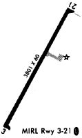
| Runways: | 03/21 |
| Longest Runway: | 03/21 is 3800 ft (1158 m) long |
| Runways with an Instrument Approach: |
61C Airport Runway Details
| Runway 03/21 | 3800 ft x 60 ft (1158 m x 18 m) | |
| Runway Length Source: | 3RD PARTY SURVEY as of 02/01/2010 | |
| Surface: | Asphalt - Good condition - No special surface treatment | |
| Runway Edge Lights: | Medium Intensity | |
Runway Weight Bearing Capacity (in thousands of pounds) |
||
| Single Wheel Landing Gear: | 12.0 | |
Runway 03 |
Runway 21 |
|
Elevation: |
798.2 | 795.3 |
Latitude: |
42-57-31.0014N | 42-58-04.0867N |
Longitude: |
088-49-15.5175W | 088-48-51.3928W |
|
Runway True Alignment: |
028 | 208 |
Glide Path Angle: |
3.0 degrees | 3.0 degrees |
Traffic Pattern: |
Left | |
Runway Markings Type: |
Nonprecision Instrument | Nonprecision Instrument |
Runway Markings Condition: |
Fair | Poor |
Visual Glide Slope Indicators: |
2-Light PAPI On Left Side Of Runway | 2-Light PAPI On Left Side Of Runway |
Threshold Crossing Height: |
32 | 33 |
Services
Airframe Repair: |
Major |
Powerplant Repair: |
Major |
Bottled Oxygen: |
None |
Bulk Oxygen: |
None |
Fuel Available: |
100LL |
Landing Fees: |
No |
Parking: |
Hangars and tiedowns available |
Maps & Diagrams
61C Sectional
Flight Planning
at skyvector.com
at skyvector.com