Location
Latitude: |
43-31-58.0441N (43.53279) |
Longitude: |
121-57-00.9321W (-121.950259) |
Elevation: |
4819.7 feet MSL (1469 m MSL) |
Magnetic Variation: |
14.2 E (as of April 2024 from WMM2020 model) |
Time Zone: |
UTC -8.0 (Standard Time) UTC -7.0 (Daylight Savings Time) |
From City: |
02 N.M. NE of Crescent Lake, Oregon |
Found On: |
Klamath Falls Chart |
FAA Region: |
ANM |
Contacts
Manager: |
Publicly owned: |
| STATE AIRPORTS MANAGER 3040 25TH ST, SE SALEM, OR 97302-1125 503-378-2523 |
OREGON DEPT. OF AVIATION 3040 25TH ST, SE SALEM, OR 97302-1125 503-378-2523 |
Operations
Airport Status: |
Operational |
Facility Use: |
Public |
Type: |
Airport |
Control tower: |
No |
Attendance (Months/Days/Hours): |
Months/Days/Hours Unattended |
Boundary ARTCC: |
ZSE (Seattle) |
Responsible ARTCC: |
ZSE (Seattle) |
Segmented Circle Indicator: |
No |
Traffic Pattern Altitude (MSL): |
5820 feet (1774 m) |
NOTAMs Facility: |
MMV |
NOTAM-D Service: |
Yes |
Based Aircraft
Annual Operations (as of 05/10/2021)
| Total Operations: | 500 | |
| GA Itinerant: | 500 | 100.0% |
Communications
| CTAF: | 122.900 |
Fixed Based Operators (FBOs) & Fuel
(Click on a business for detail)
Please help us keep this information up to date. This is a FREE SERVICE just like everything else on Airport Guide! If you see that a business needs to be added, modified, or deleted please fill out our Update Form.
To add, modify, or delete a business click here.
Please help us keep this information up to date. This is a FREE SERVICE just like everything else on Airport Guide! If you see that a business needs to be added, modified, or deleted please fill out our Update Form.
Area Code: 503 |
| Business Name | Frequency | Phone | Fuel Grade |
|---|
Flight Service Stations
| Primary | Alternate | |
| FSS on Field: | N | |
| FSS Name (ID): | Mc Minnville(MMV) | |
| Frequency: | ||
| Toll Free Phone: | 1-800-WX-BRIEF |
Instrument Procedures / Charts
Terminal Procedures are only available for airports in several countries with more being added all the time. If you are looking for a specific country's charts, please send an email to support(at)airportguide.com stating the country name. This will be used to prioritize the implementation.
Navigation Aids (Navaids) near 5S2
| Dist (NM) | ID | Morse Code | Name | Type | Freq | True Hdg | Mag Hdg |
|---|---|---|---|---|---|---|---|
| 51.5 | DSD | _ . . . . . _ . . | Deschutes | VORTAC | 117.60 | 32 | 18 |
| 61.5 | RD | . _ . _ . . | Bodey | NDB | 411 | 40 | 26 |
| 63.9 | RBG | . _ . _ . . . _ _ . | Roseburg | NDB | 400 | 254 | 240 |
| 64.7 | RBG | . _ . _ . . . _ _ . | Roseburg | VOR-DME | 108.20 | 251 | 237 |
| 65.4 | EUG | . . . _ _ _ . | Eugene | VORTAC | 112.90 | 303 | 289 |
| 68.4 | EU | . . . _ | Frakk | NDB | 260 | 307 | 293 |
| 76.0 | OED | _ _ _ . _ . . | Rogue Valley | VORTAC | 113.60 | 214 | 200 |
| 79.7 | MEF | _ _ . . . _ . | Medford | NDB | 356 | 211 | 197 |
| 81.1 | MFR | _ _ . . _ . . _ . | Medford | VOT | 117.20 | 210 | 196 |
| 82.0 | CVO | _ . _ . . . . _ _ _ _ | Corvallis | VOR-DME | 115.40 | 315 | 301 |
| 83.4 | LMT | . _ . . _ _ _ | Klamath Falls | VORTAC | 115.90 | 173 | 159 |
| 86.3 | LWG | . _ . . . _ _ _ _ . | Lewisburg | NDB | 225 | 319 | 305 |
| 88.9 | LKV | . _ . . _ . _ . . . _ | Lakeview | VORTAC | 112.00 | 134 | 120 |
| 89.9 | SL | . . . . _ . . | Turno | NDB | 266 | 331 | 317 |
| 96.8 | OTH | _ _ _ _ . . . . | North Bend | VOR-DME | 112.10 | 266 | 252 |
Nearby Airports with Fuel
Notices to Airmen (NOTAMS)
Remarks
| A110-2 | ARPT CLSD NOV 1-MAY 1 DUE TO SNOW |
| A110-3 | OWNER ADVISES CTC WITH STATE DEPT. OF AVIATION, 503-378-4880. |
| A110-4 | GRVL OCCASIONALLY ON RWY DUE TO RUN OFF. |
| A110-5 | FOR CD CTC SEATTLE ARTCC AT 253-351-3694. |
| A110-6 | SFC CONDS NOT RPRTD. |
Runways
Runway Summary
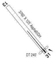
| Runways: | 13/31 |
| Longest Runway: | 13/31 is 3608 ft (1100 m) long |
| Runways with an Instrument Approach: |
5S2 Airport Runway Details
| Runway 13/31 | 3608 ft x 40 ft (1100 m x 12 m) | |
| Runway Length Source: | ADO as of 11/04/2020 | |
| Surface: | Asphalt - Excellent condition - No special surface treatment | |
Runway 13 |
Runway 31 |
|
Elevation: |
4819.7 | 4771.0 |
Latitude: |
43-32-13.0439N | 43-31-43.0442N |
Longitude: |
121-57-14.1510W | 121-56-47.7132W |
Glide Path Angle: |
0.0 degrees | 0.0 degrees |
Traffic Pattern: |
Left | Left |
Runway Markings Type: |
Basic | Basic |
Runway Markings Condition: |
Good | Good |
Object at End: |
TREES | TREES |
Object Height: |
188 | 60 |
Distance from End: |
1500 | 380 |
Object Centerline Offset: |
145 ft. left of centerline | 0 ft. left and right of centerline |
Services
Bottled Oxygen: |
None |
Bulk Oxygen: |
None |
Fuel Available: |
100LL, Jet A |
Landing Fees: |
No |
Parking: |
Tiedowns available |
Maps & Diagrams
5S2 Sectional
Flight Planning
at skyvector.com
at skyvector.com