Location
Latitude: |
32-18-11.0280N (32.303063) |
Longitude: |
084-00-26.8850W (-84.007468) |
Elevation: |
345.3 feet MSL (105 m MSL) |
Magnetic Variation: |
5.6 W (as of April 2024 from WMM2020 model) |
Time Zone: |
UTC -5.0 (Standard Time) UTC -4.0 (Daylight Savings Time) |
From City: |
01 N.M. E of Montezuma, Georgia |
Found On: |
Atlanta Chart |
FAA Region: |
ASO |
Contacts
Manager: |
Publicly owned: |
| MEL FULGHOM CITY HALL, P.O. BOX 388 MONTEZUMA, GA 31063 478-472-8144 |
CITY OF MONTEZUMA CITY HALL, P.O. BOX 388 MONTEZUMA, GA 31063 478-472-8144 |
Operations
Airport Status: |
Operational |
Facility Use: |
Public |
Type: |
Airport |
Activation Date: |
09/1962 |
Control tower: |
No |
Attendance (Months/Days/Hours): |
Months/Days/Hours Unattended |
Boundary ARTCC: |
ZTL (Atlanta) |
Responsible ARTCC: |
ZTL (Atlanta) |
Lighting Schedule: |
SEE RMK |
Segmented Circle Indicator: |
No |
Traffic Pattern Altitude (MSL): |
1345 feet (410 m) |
NOTAMs Facility: |
MCN |
NOTAM-D Service: |
Yes |
International Airport of Entry: |
No |
Customs Landing Rights: |
No |
Military Landing Rights: |
Yes |
Civil/Military Joint Use: |
No |
Based Aircraft
| Single Engine: | 9 |
| Multi Engine: | 2 |
Annual Operations (as of 12/01/2021)
| Total Operations: | 5000 | |
| GA Local: | 3500 | 70.0% |
| GA Itinerant: | 1500 | 30.0% |
Communications
| CTAF: | 122.900 |
| Approach: | ATLANTA 124.2 124.2 124.2 ATLANTA ARTCC |
| Departure: | ATLANTA 124.2 124.2 124.2 ATLANTA ARTCC |
- ATLANTA LARGE TRACON PROVIDES APCH/DEP SVC 0615-2300 ON FREQ 124.2/279.6 ; ATLANTA ARTCC PROVIDES APCH/DEP SVC 2300-0615 ON FREQS 134.5/360.75 (MACON RCAG).
Fixed Based Operators (FBOs) & Fuel
(Click on a business for detail)
Please help us keep this information up to date. This is a FREE SERVICE just like everything else on Airport Guide! If you see that a business needs to be added, modified, or deleted please fill out our Update Form.
To add, modify, or delete a business click here.
Please help us keep this information up to date. This is a FREE SERVICE just like everything else on Airport Guide! If you see that a business needs to be added, modified, or deleted please fill out our Update Form.
Area Code: 912 |
| Business Name | Frequency | Phone | Fuel Grade |
|---|
Flight Service Stations
| Primary | Alternate | |
| FSS on Field: | N | |
| FSS Name (ID): | Macon(MCN) | |
| Frequency: | ||
| Toll Free Phone: | 1-800-WX-BRIEF |
Instrument Procedures / Charts
FAA Terminal Procedures valid from 0901Z 03/21/24 to 0901Z 04/18/24.
There are various types of charts available for an airport. They are listed in the Page Type column. Here is a legend for those types:
APD - Airport Diagram
DP - Departure Procedure Charts
HOT - Hot Spots
IAP - Instrument Approach Procedure Charts
MIN - Minimums
STAR - Standard Terminal Arrival Charts
| Page Type | Page Name | Volume | Action Since Last Cycle |
|---|---|---|---|
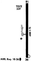
| IAP | RNAV (GPS) RWY 18 | SE-4 | |
| IAP | RNAV (GPS) RWY 36 | SE-4 | |
| MIN | TAKEOFF MINIMUMS | SE-4 |
Terminal Procedures are only available for airports in several countries with more being added all the time. If you are looking for a specific country's charts, please send an email to support(at)airportguide.com stating the country name. This will be used to prioritize the implementation.
Navigation Aids (Navaids) near 53A
| Dist (NM) | ID | Morse Code | Name | Type | Freq | True Hdg | Mag Hdg |
|---|---|---|---|---|---|---|---|
| 3.8 | IZS | . . _ _ . . . . . | Montezuma | NDB | 426 | 0 | 6 |
| 9.3 | LKG | . _ . . _ . _ _ _ . | Lindbergh | NDB | 242 | 213 | 219 |
| 15.4 | BEP | _ . . . . . _ _ . | Bay Creek | NDB | 350 | 52 | 58 |
| 19.8 | OHY | _ _ _ . . . . _ . _ _ | Coney | NDB | 400 | 157 | 163 |
| 26.4 | VNA | . . . _ _ . . _ | Vienna | VORTAC | 116.50 | 101 | 107 |
| 29.3 | WRB | . _ _ . _ . _ . . . | Robins | TACAN | 135.30 | 46 | 52 |
| 29.6 | MCN | _ _ _ . _ . _ . | Macon | DME | 114.2 | 37 | 43 |
| 38.1 | OP | _ _ _ . _ _ . | Yates | NDB | 339 | 346 | 352 |
| 41.5 | PZD | . _ _ . _ _ . . _ . . | Pecan | VOR-DME | 116.10 | 200 | 205 |
| 44.5 | EZM | . _ _ . . _ _ | Eastman | NDB | 366 | 103 | 109 |
| 50.0 | LSF | . _ . . . . . . . _ . | Lawson | VOR-DME | 111.40 | 272 | 277 |
| 51.5 | AWS | . _ . _ _ . . . | Lawson | NDB | 335 | 269 | 274 |
| 51.6 | DB | _ . . _ . . . | Creke | NDB | 251 | 77 | 83 |
| 52.6 | AB | . _ _ . . . | Putny | NDB | 227 | 195 | 200 |
| 53.2 | CS | _ . _ . . . . | Fenix | NDB | 355 | 279 | 284 |
| 54.4 | PIM | . _ _ . . . _ _ | Pine Mountain | NDB | 272 | 306 | 311 |
| 54.5 | CSG | _ . _ . . . . _ _ . | Columbus | TACAN | 117.10 | 290 | 295 |
| 55.2 | SUR | . . . . . _ . _ . | Fitzgerald | NDB | 362 | 138 | 144 |
| 58.5 | MQW | _ _ _ _ . _ . _ _ | Mc Rae | NDB | 280 | 101 | 107 |
| 58.7 | IFM | . . . . _ . _ _ | Tift Myers | VOR | 112.50 | 153 | 159 |
Nearby Airports with Fuel
Notices to Airmen (NOTAMS)
Remarks
| A110-1 | FOR CD CTC ATLANTA APCH AT 678-364-6132, WHEN APCH CLSD CTC ATLANTA ARTCC AT 770-210-7692. |
| A57-18 | 34:1 TO DISPLACED THRESHOLD |
| A81-APT | ACTVT PAPI RWY 18 & 36; MIRL RWY 18/36 - CTAF. |
| E111 | VFR OPNS ONLY |
Runways
Runway Summary
| Runways: | 18/36 |
| Longest Runway: | 18/36 is 5003 ft (1525 m) long |
| Runways with an Instrument Approach: |
53A Airport Runway Details
| Runway 18/36 | 5003 ft x 75 ft (1525 m x 23 m) | |
| Runway Length Source: | 3RD PARTY SURVEY as of 06/03/2020 | |
| Surface: | Asphalt - Good condition - No special surface treatment | |
| Runway Edge Lights: | Medium Intensity | |
Runway Weight Bearing Capacity (in thousands of pounds) |
||
| Single Wheel Landing Gear: | 30.0 | |
Runway 18 |
Runway 36 |
|
Elevation: |
345.3 | 337.1 |
Latitude: |
32-18-35.7791N | 32-17-46.2774N |
Longitude: |
084-00-26.6173W | 084-00-27.1525W |
|
Runway True Alignment: |
181 | 001 |
Glide Path Angle: |
3.3 degrees | 3.0 degrees |
Traffic Pattern: |
Left | Left |
Runway Markings Type: |
Nonprecision Instrument | Nonprecision Instrument |
Runway Markings Condition: |
Good | Good |
Object at End: |
GND | POLE |
Object Height: |
11 | 26 |
Distance from End: |
420 | 1084 |
Object Centerline Offset: |
0 ft. left and right of centerline | 250 ft. left of centerline |
Visual Glide Slope Indicators: |
2-Light PAPI On Left Side Of Runway | 2-Light PAPI On Left Side Of Runway |
Threshold Crossing Height: |
35 | 31 |
Threshold Elevation: |
334.9 | |
Displaced Threshold: |
783 | |
Threshold Latitude: |
32-18-28.0360N | |
Threshold Longitude: |
084-00-26.7025W |
Services
Airframe Repair: |
Major |
Powerplant Repair: |
Minor |
Bottled Oxygen: |
None |
Bulk Oxygen: |
None |
Fuel Available: |
100LL, Jet A+ |
Landing Fees: |
No |
Parking: |
Tiedowns available |
Maps & Diagrams
53A Sectional
Flight Planning
at skyvector.com
at skyvector.com