Location
Latitude: |
38-27-27.0950N (38.457526) |
Longitude: |
101-21-03.1130W (-101.350865) |
Elevation: |
3302.9 feet MSL (1007 m MSL) |
Magnetic Variation: |
5.6 E (as of April 2024 from WMM2020 model) |
Time Zone: |
UTC -6.0 (Standard Time) UTC -5.0 (Daylight Savings Time) |
From City: |
02 N.M. S of Leoti, Kansas |
Found On: |
Wichita Chart |
FAA Region: |
ACE |
Contacts
Manager: |
Publicly owned: |
| DOUG MCKINNEY 511 W. BROADWAY LEOTI, KS 67861 620-874-0432 |
LEOTI CITY WICHITA CO 206 S 4TH ST, PO BOX 1595 LEOTI, KS 67861 620-375-2731 |
Operations
Airport Status: |
Operational |
Facility Use: |
Public |
Type: |
Airport |
Activation Date: |
08/1957 |
Control tower: |
No |
Attendance (Months/Days/Hours): |
Months/Days/Hours Unattended |
Boundary ARTCC: |
ZDV (Denver) |
Responsible ARTCC: |
ZDV (Denver) |
Lighting Schedule: |
SEE RMK |
Segmented Circle Indicator: |
Yes |
Traffic Pattern Altitude (MSL): |
4303 feet (1312 m) |
NOTAMs Facility: |
ICT |
NOTAM-D Service: |
Yes |
Civil/Military Joint Use: |
No |
Based Aircraft
| Single Engine: | 16 |
Annual Operations (as of 09/07/2021)
| Total Operations: | 5000 | |
| GA Local: | 4000 | 80.0% |
| GA Itinerant: | 1000 | 20.0% |
Communications
| CTAF: | 122.700 |
| Unicom: | 122.700 |
- APCH/DEP CTL SVC PRVDD BY DENVER ARTCC (ZDV) ON FREQS 132.7/226.675 (GOODLAND RCAG).
Fixed Based Operators (FBOs) & Fuel
(Click on a business for detail)
Please help us keep this information up to date. This is a FREE SERVICE just like everything else on Airport Guide! If you see that a business needs to be added, modified, or deleted please fill out our Update Form.
To add, modify, or delete a business click here.
Please help us keep this information up to date. This is a FREE SERVICE just like everything else on Airport Guide! If you see that a business needs to be added, modified, or deleted please fill out our Update Form.
Area Code: 620 |
| Business Name | Frequency | Phone | Fuel Grade |
|---|---|---|---|
| Leoti Spraying Service
Update FBO info |
375-4316 | 100LL |
Flight Service Stations
| Primary | Alternate | |
| FSS on Field: | N | |
| FSS Name (ID): | Wichita(ICT) | |
| Frequency: | ||
| Toll Free Phone: | 1-800-WX-BRIEF |
Instrument Procedures / Charts
FAA Terminal Procedures valid from 0901Z 03/21/24 to 0901Z 04/18/24.
There are various types of charts available for an airport. They are listed in the Page Type column. Here is a legend for those types:
APD - Airport Diagram
DP - Departure Procedure Charts
HOT - Hot Spots
IAP - Instrument Approach Procedure Charts
MIN - Minimums
STAR - Standard Terminal Arrival Charts
| Page Type | Page Name | Volume | Action Since Last Cycle |
|---|---|---|---|
| IAP | RNAV (GPS) RWY 17 | NC-2 | |
| IAP | RNAV (GPS) RWY 35 | NC-2 | |
| MIN | TAKEOFF MINIMUMS | NC-2 |
Terminal Procedures are only available for airports in several countries with more being added all the time. If you are looking for a specific country's charts, please send an email to support(at)airportguide.com stating the country name. This will be used to prioritize the implementation.
Navigation Aids (Navaids) near 3K7
| Dist (NM) | ID | Morse Code | Name | Type | Freq | True Hdg | Mag Hdg |
|---|---|---|---|---|---|---|---|
| 21.8 | TQK | _ _ _ . _ _ . _ | Scott City | NDB | 256 | 86 | 81 |
| 43.8 | GCK | _ _ . _ . _ . _ . _ | Garden City | VORTAC | 113.30 | 137 | 132 |
| 46.6 | OEL | _ _ _ . . _ . . | Oakley | NDB | 380 | 32 | 27 |
| 47.9 | GC | _ _ . _ . _ . | Pieve | NDB | 347 | 141 | 136 |
| 51.5 | GL | _ _ . . _ . . | Shugr | NDB | 414 | 347 | 341 |
| 51.6 | ULS | . . _ . _ . . . . . | Ulysses | NDB | 395 | 180 | 174 |
| 52.5 | JHN | . _ _ _ . . . . _ . | Bear Creek | NDB | 341 | 200 | 194 |
| 58.1 | GLD | _ _ . . _ . . _ . . | Goodland | VORTAC | 115.10 | 344 | 338 |
| 64.3 | ITR | . . _ . _ . | Kit Carson | NDB | 209 | 317 | 311 |
| 64.7 | JDM | . _ _ _ _ . . _ _ | Wheatfield | NDB | 408 | 12 | 7 |
| 64.8 | LAA | . _ . . . _ . _ | Lamar | VOR-DME | 116.90 | 256 | 250 |
| 71.2 | HLC | . . . . . _ . . _ . _ . | Hill City | VORTAC | 113.70 | 47 | 42 |
| 73.2 | DDC | _ . . _ . . _ . _ . | Dodge City | VORTAC | 108.20 | 119 | 114 |
| 77.6 | HQG | . . . . _ _ . _ _ _ . | Hugoton | NDB | 365 | 180 | 174 |
| 78.7 | SYF | . . . _ . _ _ . . _ . | St Francis | NDB | 386 | 345 | 339 |
| 86.7 | LBL | . _ . . _ . . . . _ . . | Liberal | TACAN | 112.30 | 167 | 162 |
| 90.6 | OIN | _ _ _ . . _ . | Oberlin | NDB | 341 | 24 | 19 |
| 91.0 | EHA | . . . . . . _ | Elkhart | NDB | 377 | 196 | 190 |
| 91.5 | LB | . _ . . _ . . . | Panck | NDB | 383 | 168 | 163 |
| 100.0 | HYS | . . . . _ . _ _ . . . | Hays | VORTAC | 110.40 | 75 | 70 |
Nearby Airports with Fuel
Notices to Airmen (NOTAMS)
Remarks
| A110-1 | 24 HR PUBLIC TELEPHONE AVBL 620-375-4649. |
| A110-2 | FOR CD CTC DENVER ARTCC AT 303-651-4257. |
| A43-35 | PAPI UNUSBL BYD 8 DEGS RIGHT OF CNTRLN. |
| A70-FUEL-10 | 0LL FOR FUEL CALL 620-375-2723/4950. |
| A81-APT | ACTVT PAPI RWY 17 & 35, MIRL RWY 17/35 - CTAF. |
Runways
Runway Summary
| Runways: | 17/35 |
| Longest Runway: | 17/35 is 5100 ft (1554 m) long |
| Runways with an Instrument Approach: |
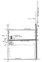
3K7 Airport Runway Details
| Runway 17/35 | 5100 ft x 75 ft (1554 m x 23 m) | |
| Runway Length Source: | 3RD PARTY SURVEY as of 02/23/2021 | |
| Surface: | Concrete - Excellent condition - No special surface treatment | |
| Runway Pavement Class: | 5 /R/C/W/T | |
| Runway Edge Lights: | Medium Intensity | |
Runway 17 |
Runway 35 |
|
Elevation: |
3302.9 | 3298.0 |
Latitude: |
38-27-52.3005N | 38-27-01.8904N |
Longitude: |
101-21-03.1450W | 101-21-03.0808W |
|
Runway True Alignment: |
180 | 360 |
Glide Path Angle: |
3.0 degrees | 3.0 degrees |
Traffic Pattern: |
Left | Left |
Runway Markings Type: |
Nonprecision Instrument | Nonprecision Instrument |
Runway Markings Condition: |
Good | Good |
Visual Glide Slope Indicators: |
2-Light PAPI On Left Side Of Runway | 2-Light PAPI On Left Side Of Runway |
Threshold Crossing Height: |
40 | 40 |
Declared Distances |
||
Take Off Run Avbl. (TORA): |
5100 | 5100 |
Take Off Distance Avbl. (TODA): |
5100 | 5100 |
Actual Stop Dist. Avbl. (ASDA): |
5100 | 5100 |
Landing Dist. Avbl. (LDA): |
5100 | 5100 |
Services
Airframe Repair: |
Major |
Powerplant Repair: |
Major |
Bottled Oxygen: |
None |
Bulk Oxygen: |
None |
Fuel Available: |
100LL |
Landing Fees: |
No |
Parking: |
Hangars and tiedowns available |
Maps & Diagrams
3K7 Sectional
Flight Planning
at skyvector.com
at skyvector.com