Location
Latitude: |
41-00-11.0200N (41.003061) |
Longitude: |
081-45-23.4790W (-81.756522) |
Elevation: |
973.7 feet MSL (297 m MSL) |
Magnetic Variation: |
8.2 W (as of April 2024 from WMM2020 model) |
Time Zone: |
UTC -5.0 (Standard Time) UTC -4.0 (Daylight Savings Time) |
From City: |
02 N.M. SW of Wadsworth, Ohio |
Found On: |
Detroit Chart |
FAA Region: |
AGL |
Contacts
Manager: |
Publicly owned: |
| MARK MILLER 840 AIRPORT DR WADSWORTH, OH 44281-9552 330-334-9861 |
CITY OF WADSWORTH ARPT COMMISSION WADSWORTH MUNICIPAL BLDG, 120 MAPLE ST WADSWORTH, OH 44281-1825 330-335-1521 |
Operations
Airport Status: |
Operational |
Facility Use: |
Public |
Type: |
Airport |
Activation Date: |
10/1956 |
Control tower: |
No |
Attendance (Months/Days/Hours): |
Months/Days/Hours ALL/ALL/ALL |
Boundary ARTCC: |
ZOB (Cleveland) |
Responsible ARTCC: |
ZOB (Cleveland) |
Lighting Schedule: |
SEE RMK |
Segmented Circle Indicator: |
No |
Traffic Pattern Altitude (MSL): |
1974 feet (602 m) |
NOTAMs Facility: |
CLE |
NOTAM-D Service: |
Yes |
International Airport of Entry: |
No |
Customs Landing Rights: |
No |
Military Landing Rights: |
No |
Civil/Military Joint Use: |
No |
Based Aircraft
| Single Engine: | 84 |
| Multi Engine: | 6 |
| GA Helicopters: | 1 |
| Gliders: | 4 |
Annual Operations (as of 10/15/2020)
| Total Operations: | 42550 | |
| Air Taxi: | 500 | 1.2% |
| GA Local: | 30000 | 70.5% |
| GA Itinerant: | 12000 | 28.2% |
| Military Aircraft: | 50 | 0.1% |
Communications
| CTAF: | 122.800 |
| Unicom: | 122.800 |
| Approach: | CLEVELAND 125.5 125.5 CLEVELAND ARTCC |
| Departure: | CLEVELAND 125.5 125.5 CLEVELAND ARTCC |
- APCH/DEP SVC PRVDD BY CLEVELAND APCH (CLE) 0600-0100. APCH/DEP SVC PRVDD BY CLEVELAND ARTCC (ZOB) ON FREQS 134.9/269.475 (MANSFIELD RCAG) 0100-0600.
Fixed Based Operators (FBOs) & Fuel
(Click on a business for detail)
Please help us keep this information up to date. This is a FREE SERVICE just like everything else on Airport Guide! If you see that a business needs to be added, modified, or deleted please fill out our Update Form.
To add, modify, or delete a business click here.
Please help us keep this information up to date. This is a FREE SERVICE just like everything else on Airport Guide! If you see that a business needs to be added, modified, or deleted please fill out our Update Form.
Area Code: 330 |
| Business Name | Frequency | Phone | Fuel Grade |
|---|---|---|---|
| Wadsworth Airport Assoc.
Update FBO info |
Unicom 122.8 | 334-9861 | 80, 100LL, Jet A |
Flight Service Stations
| Primary | Alternate | |
| FSS on Field: | N | |
| FSS Name (ID): | Cleveland(CLE) | |
| Frequency: | ||
| Toll Free Phone: | 1-800-WX-BRIEF |
Instrument Procedures / Charts
FAA Terminal Procedures valid from 0901Z 03/21/24 to 0901Z 04/18/24.
There are various types of charts available for an airport. They are listed in the Page Type column. Here is a legend for those types:
APD - Airport Diagram
DP - Departure Procedure Charts
HOT - Hot Spots
IAP - Instrument Approach Procedure Charts
MIN - Minimums
STAR - Standard Terminal Arrival Charts
| Page Type | Page Name | Volume | Action Since Last Cycle |
|---|---|---|---|
| IAP | RNAV (GPS) RWY 02 | EC-2 | |
| IAP | RNAV (GPS) RWY 20 | EC-2 | |
| MIN | TAKEOFF MINIMUMS | EC-2 |
Terminal Procedures are only available for airports in several countries with more being added all the time. If you are looking for a specific country's charts, please send an email to support(at)airportguide.com stating the country name. This will be used to prioritize the implementation.
Navigation Aids (Navaids) near 3G3
| Dist (NM) | ID | Morse Code | Name | Type | Freq | True Hdg | Mag Hdg |
|---|---|---|---|---|---|---|---|
| 15.2 | CAK | _ . _ . . _ _ . _ | Akron/Canton Regional | VOT | 110.60 | 109 | 117 |
| 17.2 | AK | . _ _ . _ | Akron | NDB | 362 | 76 | 84 |
| 21.6 | BSV | _ . . . . . . . . . _ | Briggs | VOR-DME | 112.40 | 136 | 144 |
| 22.6 | AAU | . _ . _ . . _ | Ashland | NDB | 329 | 264 | 272 |
| 25.3 | CLE | _ . _ . . _ . . . | Cleveland | VOT | 110.40 | 350 | 358 |
| 25.9 | ACO | . _ _ . _ . _ _ _ | Akron | VOR-DME | 114.40 | 75 | 83 |
| 28.1 | DJB | _ . . . _ _ _ _ . . . | Dryer | VOR-DME | 113.60 | 319 | 327 |
| 28.2 | MLR | _ _ . _ . . . _ . | Millersburg/Dcmsnd | NDB | 382 | 190 | 198 |
| 34.3 | MF | _ _ . . _ . | Manns | NDB | 372 | 245 | 253 |
| 38.7 | MFD | _ _ . . _ . _ . . | Mansfield | VORTAC | 108.80 | 258 | 266 |
| 40.8 | CXR | _ . _ . _ . . _ . _ . | Chardon | VOR-DME | 112.70 | 40 | 48 |
| 44.2 | LQL | . _ . . _ _ . _ . _ . . | Lakeland | NDB | 263 | 22 | 30 |
| 48.1 | SKY | . . . _ . _ _ . _ _ | Sandusky | VOR-DME | 109.20 | 302 | 310 |
| 48.2 | CTW | _ . _ . _ . _ _ | Newcomerstown | DME | 111.8 | 164 | 172 |
| 52.7 | YNG | _ . _ _ _ . _ _ . | Youngstown | VORTAC | 109.00 | 67 | 76 |
| 53.8 | YN | _ . _ _ _ . | Fetch | NDB | 338 | 76 | 85 |
| 56.1 | HBD | . . . . _ . . . _ . . | Hubbard | NDB | 408 | 80 | 89 |
| 57.1 | CFX | _ . _ . . . _ . _ . . _ | Cadiz | NDB | 239 | 143 | 151 |
| 58.9 | PCW | . _ _ . _ . _ . . _ _ | Port Clinton | NDB | 423 | 302 | 310 |
| 60.7 | UCP | . . _ _ . _ . . _ _ . | Castle | NDB | 272 | 88 | 97 |
Nearby Airports with Fuel
Notices to Airmen (NOTAMS)
Remarks
| A110-10 | CAUTION: EXTSV HEL OPS. |
| A110-11 | RWY 02 TFC PAT PREFERRED ENTRY AT 45 DEGS TO UPWIND LEG TO AVOID TFC AT 15G ARPT 2.5 NM NW. |
| A110-2 | RWY 10 CLSD FOR DEPARTURE WHEN WIND LESS THAN 15 KTS FM THE EAST. |
| A110-4 | NO LINE OF SIGHT BTN RWY'S 02 & 10. |
| A110-5 | RWY 20 CALM WIND RWY BLO 4 KTS FOR NOISE ABATEMENT. AVOID HOSPITAL TO THE N. |
| A110-6 | FOR CD CTC CLEVELAND APCH AT 216-352-2323, WHEN APCH CLSD CTC CLEVELAND ARTCC AT 440-774-0223. |
| A110-7 | TWY B CLSD TO PWRD ACFT |
| A110-8 | BIRDS, DEER, & OTR WILDLIFE ON & INVOF ARPT. |
| A110-9 | CAUTION: GLIDER OPS ALL RWY'S |
| A16 | OR 330-241-2562. |
| A58-02 | +4 FT FENCE, 0-200 FT DIST, 175-220 FT R, OBST CLNC SLP 0:1 TO DTHR. |
| A58-10 | +20 FT TWY, 0-185 FT DIST, 100 FT L; +20 FT TWY, 0-85 FT DIST, 110 FT R. |
| A58-20 | +4 FT FENCE, 85-200 FT DIST, 233-250 FT L, OBST CLNC SLP 0:1. |
| A81-APT | ACTVT MIRL RWY 02/20 - CTAF. VASI RWY 02 & 20 OPR CONSLY. |
| E111 | VFR ONLY. |
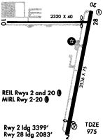
Runways
Runway Summary
| Runways: | 02/20 10/28 |
| Longest Runway: | 02/20 is 3530 ft (1076 m) long |
| Runways with an Instrument Approach: |
3G3 Airport Runway Details
| Runway 02/20 | 3530 ft x 75 ft (1076 m x 23 m) | |
| Runway Length Source: | 3RD PARTY SURVEY as of 11/01/2019 | |
| Surface: | Asphalt - Good condition - No special surface treatment | |
| Runway Edge Lights: | Medium Intensity | |
Runway 02 |
Runway 20 |
|
Elevation: |
965.0 | 973.6 |
Latitude: |
40-59-48.5673N | 41-00-22.8570N |
Longitude: |
081-45-22.6647W | 081-45-14.2397W |
|
Runway True Alignment: |
011 | 191 |
Glide Path Angle: |
3.5 degrees | 3.5 degrees |
Traffic Pattern: |
Left | Left |
Runway Markings Type: |
Nonprecision Instrument | Nonprecision Instrument |
Runway Markings Condition: |
Fair | Fair |
Object at End: |
FENCE | FENCE |
Object Height: |
4 | 4 |
Distance from End: |
201 | 201 |
Object Centerline Offset: |
175 ft. right of centerline | 233 ft. left of centerline |
Visual Glide Slope Indicators: |
2-Box VASI On Right Side Of Runway | 2-Box VASI On Left Side Of Runway |
REIL: |
No | No |
Touchdown Lights: |
No | No |
Centerline Lights: |
No | No |
Threshold Crossing Height: |
24 | 24 |
Threshold Elevation: |
965.1 | |
Displaced Threshold: |
130 | |
Threshold Latitude: |
40-59-49.8251N | |
Threshold Longitude: |
081-45-22.3559W |
| Runway 10/28 | 2155 ft x 35 ft (657 m x 11 m) | |
| Runway Length Source: | 3RD PARTY SURVEY as of 11/01/2019 | |
| Surface: | Asphalt - Good condition - No special surface treatment | |
Runway 10 |
Runway 28 |
|
Elevation: |
962.8 | 971.1 |
Latitude: |
41-00-19.7505N | 41-00-19.6768N |
Longitude: |
081-45-45.7682W | 081-45-17.6590W |
|
Runway True Alignment: |
090 | 270 |
Glide Path Angle: |
0.0 degrees | 0.0 degrees |
Traffic Pattern: |
Left | Left |
Runway Markings Type: |
Basic | Basic |
Runway Markings Condition: |
Good | Good |
Object at End: |
POLE | TREE |
Object Height: |
31 | 90 |
Distance from End: |
281 | 859 |
Object Centerline Offset: |
175 ft. right of centerline | 233 ft. left of centerline |
REIL: |
No | No |
Touchdown Lights: |
No | No |
Centerline Lights: |
No | No |
Services
Airframe Repair: |
Major |
Powerplant Repair: |
Major |
Bottled Oxygen: |
None |
Bulk Oxygen: |
None |
Fuel Available: |
100LL, Jet A |
Landing Fees: |
No |
Parking: |
Hangars and tiedowns available |
Maps & Diagrams
3G3 Sectional
Flight Planning
at skyvector.com
at skyvector.com