Location
Latitude: |
43-12-21.2000N (43.205889) |
Longitude: |
076-10-45.5000W (-76.179306) |
Elevation: |
385.0 feet MSL (117 m MSL) |
Magnetic Variation: |
12 W (as of April 2024 from WMM2020 model) |
Time Zone: |
UTC -5.0 (Standard Time) UTC -4.0 (Daylight Savings Time) |
From City: |
01 N.M. N of Clay, New York |
Found On: |
New York Chart |
FAA Region: |
AEA |
Contacts
Manager: |
Privately owned: |
| RAYMOND FLORCZYK 4885 VER PLANK RD CLAY, NY 13041 315-699-5734 |
RAYMOND FLORCZYK 4885 VER PLANK RD CLAY, NY 13041 315-699-5734 |
Operations
Airport Status: |
Operational |
Facility Use: |
Public |
Type: |
Airport |
Activation Date: |
10/1955 |
Control tower: |
No |
Attendance (Months/Days/Hours): |
Months/Days/Hours ALL/ALL/DALGT |
Boundary ARTCC: |
ZBW (Boston) |
Responsible ARTCC: |
ZBW (Boston) |
Segmented Circle Indicator: |
No |
Traffic Pattern Altitude (MSL): |
1385 feet (422 m) |
NOTAMs Facility: |
BUF |
NOTAM-D Service: |
Yes |
International Airport of Entry: |
No |
Customs Landing Rights: |
No |
Military Landing Rights: |
No |
Civil/Military Joint Use: |
No |
Based Aircraft
| Single Engine: | 1 |
Annual Operations (as of 08/30/2018)
| Total Operations: | 530 | |
| GA Local: | 500 | 94.3% |
| GA Itinerant: | 30 | 5.7% |
Communications
| CTAF: | 122.900 |
Fixed Based Operators (FBOs) & Fuel
(Click on a business for detail)
Please help us keep this information up to date. This is a FREE SERVICE just like everything else on Airport Guide! If you see that a business needs to be added, modified, or deleted please fill out our Update Form.
To add, modify, or delete a business click here.
Please help us keep this information up to date. This is a FREE SERVICE just like everything else on Airport Guide! If you see that a business needs to be added, modified, or deleted please fill out our Update Form.
Area Code: 315 |
| Business Name | Frequency | Phone | Fuel Grade |
|---|
Flight Service Stations
| Primary | Alternate | |
| FSS on Field: | N | |
| FSS Name (ID): | Buffalo(BUF) | |
| Frequency: | ||
| Toll Free Phone: | 1-800-WX-BRIEF |
Instrument Procedures / Charts
Terminal Procedures are only available for airports in several countries with more being added all the time. If you are looking for a specific country's charts, please send an email to support(at)airportguide.com stating the country name. This will be used to prioritize the implementation.
Navigation Aids (Navaids) near 1H1
| Dist (NM) | ID | Morse Code | Name | Type | Freq | True Hdg | Mag Hdg |
|---|---|---|---|---|---|---|---|
| 2.9 | SYR | . . . _ . _ _ . _ . | Syracuse | VORTAC | 117.00 | 202 | 214 |
| 7.4 | FZ | . . _ . _ _ . . | Falln | NDB | 220 | 311 | 323 |
| 29.4 | GGT | _ _ . _ _ . _ | Georgetown | TACAN | 117.80 | 148 | 160 |
| 44.4 | ITH | . . _ . . . . | Ithaca | DME | 111.8 | 196 | 208 |
| 45.0 | ART | . _ . _ . _ | Watertown | VORTAC | 109.80 | 6 | 18 |
| 45.7 | UCA | . . _ _ . _ . . _ | Utica | TACAN | 111.20 | 103 | 115 |
| 47.3 | IT | . . _ | Vrnah | NDB | 266 | 190 | 202 |
| 51.2 | PYA | . _ _ . _ . _ _ . _ | Penn Yan | NDB | 260 | 229 | 241 |
| 55.3 | GTB | _ _ . _ _ . . . | Drum | NDB | 257 | 20 | 32 |
| 60.7 | RKA | . _ . _ . _ . _ | Rockdale | VOR-DME | 112.60 | 136 | 148 |
| 62.9 | CFB | _ . _ . . . _ . _ . . . | Binghamton | VOR-DME | 112.20 | 178 | 190 |
| 63.5 | ALP | . _ . _ . . . _ _ . | Alpine | NDB | 245 | 204 | 216 |
| 64.3 | OZ | _ _ _ _ _ . . | Kring | NDB | 279 | 125 | 137 |
| 65.6 | ROC | . _ . _ _ _ _ . _ . | Rochester | VOR-DME | 110.00 | 265 | 277 |
| 67.3 | BG | _ . . . _ _ . | Smite | NDB | 332 | 169 | 181 |
| 68.0 | YGK | Kingston | NDB | 263 | 344 | 356 | |
| 70.6 | AVN | . _ . . . _ _ . | Avon | NDB | 344 | 260 | 272 |
| 71.7 | GEE | _ _ . . . | Geneseo | VOR-DME | 108.20 | 252 | 264 |
| 76.4 | ULW | . . _ . _ . . . _ _ | Elmira | VOR-DME | 109.65 | 209 | 221 |
| 76.9 | 6M | Belleville | NDB | 283 | 320 | 332 |
Nearby Airports with Fuel
Notices to Airmen (NOTAMS)
Remarks
| A110-1 | |
| A110-2 | FIELD SOFT LATE FALL & EARLY SPRING. |
| A110-3 | PARA PLANE ACTIVITY - EVENINGS & WEEKENDS. |
| A110-4 | RY 01 30 FT PLINE 260 FT FM THLD. |
| A110-5 | DEER ON & INVOF ARPT. |
| A110-6 | RY 10 LINE OF TREES, +95 FT HIGH, 55 FT LEFT. |
| A110-7 | FOR CD CTC SYRACUSE APCH AT 315-455-6218. |
| A110-8 | 100 FT LONG PARL DITCH RT EDGE OF RWY 01 FIRST 300 FT. |
| A110-9 | RWY 01 20 FT VER DROP 100 TO 400 FT FM RWY END. |
| A32-01/19 | RY 01/19 WIDTH VARIES 75 FT -90 FT. |
| A32-10/28 | RY 10/28 WIDTH VARIES 97 FT-136 FT. |
| A42-01 | 01/19 EDGES MARKED WITH BARRELS. |
| A42-10 | 10/28 EDGES MARKED WITH BARRELS. |
| E111 | NON COMPLIANCE WITH FAR 157. |
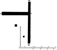
Runways
Runway Summary
| Runways: | 01/19 10/28 |
| Longest Runway: | 01/19 is 2220 ft (677 m) long |
| Runways with an Instrument Approach: |
1H1 Airport Runway Details
| Runway 01/19 | 2220 ft x 75 ft (677 m x 23 m) | |
| Surface: | Turf - Good condition - No special surface treatment | |
Runway 01 |
Runway 19 |
|
Glide Path Angle: |
0.0 degrees | 0.0 degrees |
Object at End: |
BRUSH | TREES |
Object Height: |
10 | 88 |
Distance from End: |
0 | 0 |
Object Centerline Offset: |
33 ft. left of centerline | 0 ft. left and right of centerline |
| Runway 10/28 | 1550 ft x 97 ft (472 m x 30 m) | |
| Surface: | Turf - Good condition - No special surface treatment | |
Runway 10 |
Runway 28 |
|
Elevation: |
374.0 | 372.0 |
Latitude: |
43-12-20.4587N | 43-12-22.0164N |
Longitude: |
076-10-55.8884W | 076-10-35.0635W |
|
Runway True Alignment: |
084 | 264 |
Glide Path Angle: |
0.0 degrees | 0.0 degrees |
Object at End: |
TREES | TREES |
Object Height: |
84 | 72 |
Distance from End: |
0 | 53 |
Object Centerline Offset: |
33 ft. left of centerline | 0 ft. left and right of centerline |
Services
Airframe Repair: |
None |
Powerplant Repair: |
None |
Bottled Oxygen: |
None |
Bulk Oxygen: |
None |
Fuel Available: |
100LL |
Landing Fees: |
No |
Parking: |
Hangars and tiedowns available |
Maps & Diagrams
1H1 Sectional
Flight Planning
at skyvector.com
at skyvector.com