Location
Latitude: |
44-44-40.5000N (44.744583) |
Longitude: |
114-55-17.0000W (-114.921389) |
Elevation: |
4618.0 feet MSL (1408 m MSL) |
Magnetic Variation: |
12.7 E (as of April 2024 from WMM2020 model) |
Time Zone: |
UTC -7.0 (Standard Time) UTC -6.0 (Daylight Savings Time) |
From City: |
02 N.M. SE of Mahoney Creek, Idaho |
Found On: |
Great Falls Chart |
FAA Region: |
ANM |
Contacts
Manager: |
Publicly owned: |
| MIDDLE FORK DIST RANGER 1206 S. CHALLIS ST SALMON, ID 83467 208-879-4106 |
U S FOREST SERVICE 324 25TH ST OGDEN, UT 84401 801-625-5511 |
Operations
Airport Status: |
Operational |
Facility Use: |
Public |
Type: |
Airport |
Activation Date: |
08/1947 |
Control tower: |
No |
Attendance (Months/Days/Hours): |
Months/Days/Hours Unattended |
Boundary ARTCC: |
ZLC (Salt Lake City) |
Responsible ARTCC: |
ZLC (Salt Lake City) |
Segmented Circle Indicator: |
Yes |
Traffic Pattern Altitude (MSL): |
5618 feet (1712 m) |
NOTAMs Facility: |
BOI |
NOTAM-D Service: |
Yes |
Military Landing Rights: |
No |
Civil/Military Joint Use: |
No |
Based Aircraft
Annual Operations (as of 07/30/2021)
| Total Operations: | 1250 | |
| Air Taxi: | 750 | 60.0% |
| GA Itinerant: | 500 | 40.0% |
Communications
| CTAF: | 122.900 |
Fixed Based Operators (FBOs) & Fuel
(Click on a business for detail)
Please help us keep this information up to date. This is a FREE SERVICE just like everything else on Airport Guide! If you see that a business needs to be added, modified, or deleted please fill out our Update Form.
To add, modify, or delete a business click here.
Please help us keep this information up to date. This is a FREE SERVICE just like everything else on Airport Guide! If you see that a business needs to be added, modified, or deleted please fill out our Update Form.
Area Code: 208 |
| Business Name | Frequency | Phone | Fuel Grade |
|---|
Flight Service Stations
| Primary | Alternate | |
| FSS on Field: | N | |
| FSS Name (ID): | Boise(BOI) | |
| Frequency: | ||
| Toll Free Phone: | 1-800-WX-BRIEF |
Instrument Procedures / Charts
Terminal Procedures are only available for airports in several countries with more being added all the time. If you are looking for a specific country's charts, please send an email to support(at)airportguide.com stating the country name. This will be used to prioritize the implementation.
Navigation Aids (Navaids) near 0U3
| Dist (NM) | ID | Morse Code | Name | Type | Freq | True Hdg | Mag Hdg |
|---|---|---|---|---|---|---|---|
| 39.3 | LKT | . _ . . _ . _ _ | Salmon | VOR-DME | 113.50 | 64 | 51 |
| 54.8 | DNJ | _ . . _ . . _ _ _ | Donnelly | VOR-DME | 116.20 | 271 | 258 |
| 89.8 | HLE | . . . . . _ . . . | Hailey | NDB-DME | 220 | 160 | 148 |
| 90.0 | BOI | _ . . . _ _ _ . . | Boise | VORTAC | 113.30 | 217 | 204 |
| 90.6 | BOI | _ . . . _ _ _ . . | Boise | VOT | 116.70 | 218 | 205 |
| 91.3 | BO | _ . . . _ _ _ | Ustik | NDB | 359 | 221 | 208 |
| 97.6 | MPA | _ _ . _ _ . . _ | Meridian | NDB | 238 | 226 | 213 |
| 99.5 | ONO | _ _ _ _ . _ _ _ | Ontario | NDB | 305 | 244 | 231 |
Nearby Airports with Fuel
Notices to Airmen (NOTAMS)
Remarks
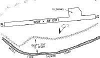
| A110-1 | NO WINTER MAINTENANCE. |
| A110-2 | RECOMMEND LNDG RY 22; TKOF RY 04 WHEN WIND CONDITIONS ALLOW. |
| A110-3 | -1' DITCH LCTD 20' FM CNTRLN BOTH SIDES OF RY. |
| A110-4 | FIRST 400 FT OF RWY 22 HAS -8 FT X 10 FT X 2 FT DEEP ELK WALLOWS BOTH SIDES OF RWY. |
| A110-5 | FOR CD CTC SALT LAKE ARTCC AT 801-320-2568. |
| A30A-04 | NE END FIRST 500 FT EXTREMELY ROUGH. |
| A42-04 | RY 04/22 THLDS & EDGES HAVE WHITE WOOD BOUNDARY MARKERS; EDGE MARKERS SET AT 65 FT WIDTH. |
| A52-22 | +180' RIDGE AT 1900' ON CNTRLN. |
| E111 | ESTABD PRIOR TO 12/31/58. |
Runways
Runway Summary
| Runways: | 04/22 |
| Longest Runway: | 04/22 is 2150 ft (655 m) long |
| Runways with an Instrument Approach: |
0U3 Airport Runway Details
| Runway 04/22 | 2150 ft x 15 ft (655 m x 5 m) | |
| Surface: | Dirt - Fair condition - No special surface treatment | |
Runway 04 |
Runway 22 |
|
Latitude: |
44-44-33.9300N | 44-44-47.0700N |
Longitude: |
114-55-28.7100W | 114-55-05.2400W |
Glide Path Angle: |
0.0 degrees | 0.0 degrees |
Traffic Pattern: |
Left | Left |
Object at End: |
HILL | HILL |
Object Height: |
600 | 285 |
Distance from End: |
3000 | 1900 |
Object Centerline Offset: |
425 ft. left of centerline | 200 ft. left of centerline |
Services
Bottled Oxygen: |
None |
Bulk Oxygen: |
None |
Fuel Available: |
100LL |
Landing Fees: |
No |
Parking: |
Tiedowns available |
Maps & Diagrams
0U3 Sectional
Flight Planning
at skyvector.com
at skyvector.com