Location
Latitude: |
41-24-44.9200N (41.412478) |
Longitude: |
078-30-09.4730W (-78.502631) |
Elevation: |
1934.3 feet MSL (590 m MSL) |
Magnetic Variation: |
10.3 W (as of April 2024 from WMM2020 model) |
Time Zone: |
UTC -5.0 (Standard Time) UTC -4.0 (Daylight Savings Time) |
From City: |
03 N.M. SE of St. Marys, Pennsylvania |
Found On: |
Detroit Chart |
FAA Region: |
AEA |
Contacts
Manager: |
Publicly owned: |
| VINCE CAGGIANO 159 CESSNA RD ST MARYS, PA 15857 814-834-4671 |
CITY OF ST. MARYS 159 CESSNA ROAD ST MARYS, PA 15857 814-834-4671 |
Operations
Airport Status: |
Operational |
Facility Use: |
Public |
Type: |
Airport |
Activation Date: |
10/1946 |
Control tower: |
No |
Attendance (Months/Days/Hours): |
Months/Days/Hours ALL/MON-FRI/0800-1600 |
Boundary ARTCC: |
ZOB (Cleveland) |
Responsible ARTCC: |
ZOB (Cleveland) |
Lighting Schedule: |
SEE RMK |
Segmented Circle Indicator: |
Yes |
Traffic Pattern Altitude (MSL): |
2934 feet (894 m) |
NOTAMs Facility: |
AOO |
NOTAM-D Service: |
Yes |
International Airport of Entry: |
No |
Customs Landing Rights: |
No |
Military Landing Rights: |
Yes |
Civil/Military Joint Use: |
No |
Based Aircraft
| Single Engine: | 13 |
| GA Helicopters: | 1 |
| Ultralights: | 5 |
Annual Operations (as of 11/01/2023)
| Total Operations: | 6245 | |
| Air Taxi: | 500 | 8.0% |
| GA Local: | 2700 | 43.2% |
| GA Itinerant: | 3000 | 48.0% |
| Military Aircraft: | 45 | 0.7% |
Communications
| CTAF: | 122.700 |
| Unicom: | 122.700 |
| AWOS-3P: | 118.05 (814-834-9416) |
- CLEARANCE DELIVERY PRVDD BY ALTOONA RADIO ON FREQ 122.4.
- APCH/DEP SVC PRVDD BY CLEVELAND ARTCC (ZOB) ON FREQS 126.725/291.65 (DUBOIS RCAG).
Fixed Based Operators (FBOs) & Fuel
(Click on a business for detail)
Please help us keep this information up to date. This is a FREE SERVICE just like everything else on Airport Guide! If you see that a business needs to be added, modified, or deleted please fill out our Update Form.
To add, modify, or delete a business click here.
Please help us keep this information up to date. This is a FREE SERVICE just like everything else on Airport Guide! If you see that a business needs to be added, modified, or deleted please fill out our Update Form.
Area Code: 814 |
| Business Name | Frequency | Phone | Fuel Grade |
|---|
Flight Service Stations
| Primary | Alternate | |
| FSS on Field: | N | |
| FSS Name (ID): | Altoona(AOO) | |
| Frequency: | ||
| Toll Free Phone: | 1-800-WX-BRIEF |
Instrument Procedures / Charts
FAA Terminal Procedures valid from 0901Z 03/21/24 to 0901Z 04/18/24.
There are various types of charts available for an airport. They are listed in the Page Type column. Here is a legend for those types:
APD - Airport Diagram
DP - Departure Procedure Charts
HOT - Hot Spots
IAP - Instrument Approach Procedure Charts
MIN - Minimums
STAR - Standard Terminal Arrival Charts
| Page Type | Page Name | Volume | Action Since Last Cycle |
|---|---|---|---|
| IAP | LOC RWY 28 | NE-4 | |
| IAP | RNAV (GPS) RWY 10 | NE-4 | |
| IAP | RNAV (GPS) RWY 28 | NE-4 | |
| IAP | VOR RWY 28 | NE-4 | |
| MIN | ALTERNATE MINIMUMS | NE-4 | |
| MIN | TAKEOFF MINIMUMS | NE-4 |
Terminal Procedures are only available for airports in several countries with more being added all the time. If you are looking for a specific country's charts, please send an email to support(at)airportguide.com stating the country name. This will be used to prioritize the implementation.
Navigation Aids (Navaids) near STQ
| Dist (NM) | ID | Morse Code | Name | Type | Freq | True Hdg | Mag Hdg |
|---|---|---|---|---|---|---|---|
| 20.1 | ETG | . _ _ _ . | Keating | VORTAC | 116.00 | 126 | 136 |
| 23.0 | BFD | _ . . . . . _ . _ . . | Bradford | DME | 116.6 | 346 | 356 |
| 24.7 | SLT | . . . . _ . . _ | Slate Run | VORTAC | 113.90 | 75 | 86 |
| 37.6 | PSB | . _ _ . . . . _ . . . | Philipsburg | VORTAC | 115.50 | 142 | 152 |
| 41.4 | TON | _ _ _ _ _ . | Tyrone | VORTAC | 114.90 | 169 | 179 |
| 44.8 | TDT | _ _ . . _ | Tidioute | DME | 117.6 | 294 | 304 |
| 45.7 | UN | . . _ _ . | Penue | NDB | 388 | 130 | 141 |
| 45.9 | CIP | _ . _ . . . . _ _ . | Clarion | DME | 112.9 | 249 | 259 |
| 46.5 | ELZ | . . _ . . _ _ . . | Wellsville | DME | 115.85 | 28 | 39 |
| 51.5 | SFK | . . . . . _ . _ . _ | Stonyfork | VOR-DME | 108.60 | 70 | 81 |
| 52.8 | LYS | . _ . . _ . _ _ . . . | Olean | NDB | 360 | 8 | 18 |
| 53.1 | REC | . _ . . _ . _ . | Revloc | VOR-DME | 110.60 | 192 | 202 |
| 53.3 | INP | . . _ . . _ _ . | Indiana | NDB | 242 | 208 | 218 |
| 54.2 | JHW | . _ _ _ . . . . . _ _ | Jamestown | VOR-DME | 114.70 | 329 | 339 |
| 59.5 | ORJ | _ _ _ . _ . . _ _ _ | Corry | NDB | 258 | 300 | 310 |
| 60.9 | FKL | . . _ . _ . _ . _ . . | Franklin | VOR | 109.60 | 271 | 281 |
| 65.8 | AOO | . _ _ _ _ _ _ _ | Altoona | VOR | 108.80 | 172 | 182 |
| 67.4 | JST | . _ _ _ . . . _ | Johnstown | VOR-DME | 113.00 | 192 | 202 |
| 71.3 | BHU | _ . . . . . . . . . _ | Benje | NDB | 382 | 209 | 219 |
| 73.3 | DKK | _ . . _ . _ _ . _ | Dunkirk | DME | 116.2 | 332 | 342 |
Nearby Airports with Fuel
Notices to Airmen (NOTAMS)
Remarks
| A110-3 | FOR CD CTC CLEVELAND ARTCC AT 440-774-0234. |
| A110-4 | COLD TEMPERATURE AIRPORT. ALTITUDE CORRECTION REQUIRED AT OR BELOW -36C. |
| A43-10 | PAPI UNUSBL BYD 5 DEGS RIGHT OF CNTRLN. |
| A43-28 | PAPI UNUSBL BYD 8 DEGS RIGHT OF CNTRLN. |
| A58-10 | +7 FT FENCE 200 FT N OF RY 0-200 FT. +15 FT PUBLIC ROAD 0-200 FT & 225 FT L. PUBLIC ROAD OBSTN MKD BY LIGHTED POLES. |
| A58-28 | +13 FT FENCE N OF RY FM 0-176 FT, 219 FT LEFT. +23 FT PUBLIC ROAD, 222 FT RIGHT. PUBLIC ROAD OBSTN MKD BY LIGHTED POLES. |
| A81-APT | ACTVT MALS RWY 28; PAPI RWYS 10 & 28; MIRL RWY 10/28 - CTAF. |
Runways
Runway Summary
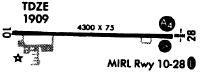
| Runways: | 10/28 |
| Longest Runway: | 10/28 is 4300 ft (1311 m) long |
| Runways with an Instrument Approach: | 28 |
STQ Airport Runway Details
| Runway 10/28 | 4300 ft x 75 ft (1311 m x 23 m) | |
| Surface: | Asphalt - Good condition - Saw-cut or plastic grooved | |
| Runway Edge Lights: | Medium Intensity | |
Runway Weight Bearing Capacity (in thousands of pounds) |
||
| Single Wheel Landing Gear: | 33.0 | |
Runway 10 |
Runway 28 |
|
Elevation: |
1902.4 | 1934.3 |
Latitude: |
41-24-44.9370N | 41-24-44.9470N |
Longitude: |
078-30-37.7320W | 078-29-41.3030W |
|
Runway True Alignment: |
090 | 270 |
ILS Type: |
LOC/DME | |
Glide Path Angle: |
3.0 degrees | 3.0 degrees |
Traffic Pattern: |
Left | Left |
Runway Markings Type: |
Nonprecision Instrument | Nonprecision Instrument |
Runway Markings Condition: |
Good | Good |
Object at End: |
TREES | TREES |
Object Height: |
74 | 31 |
Distance from End: |
2358 | 670 |
Object Centerline Offset: |
490 ft. left of centerline | 244 ft. left of centerline |
Visual Glide Slope Indicators: |
4-Light PAPI On Left Side Of Runway | 4-Light PAPI On Left Side Of Runway |
Approach Light System: |
1,400 Foot Medium Intensity Approach Lighting System | |
Threshold Crossing Height: |
41 | 39 |
Services
Airframe Repair: |
Major |
Powerplant Repair: |
Major |
Bottled Oxygen: |
High Pressure |
Bulk Oxygen: |
High Pressure |
Fuel Available: |
100LL, Jet A |
Landing Fees: |
No |
Parking: |
Hangars and tiedowns available |
Maps & Diagrams
STQ Sectional
Flight Planning
at skyvector.com
at skyvector.com