Location
Latitude: |
37-02-10.9610N (37.036378) |
Longitude: |
113-30-37.0900W (-113.510303) |
Elevation: |
2883.6 feet MSL (879 m MSL) |
Magnetic Variation: |
10.8 E (as of April 2024 from WMM2020 model) |
Time Zone: |
UTC -7.0 (Standard Time) UTC -6.0 (Daylight Savings Time) |
From City: |
05 N.M. SE of St. George, Utah |
Found On: |
Las Vegas Chart |
FAA Region: |
ANM |
Contacts
Manager: |
Publicly owned: |
| RICHARD STEHMEIER 4508 S. AIRPORT PKWY #1 ST GEORGE, UT 84790 435-627-4085 |
CITY OF ST GEORGE 175 E 200 N ST GEORGE, UT 84770 435-627-4000 |
Operations
Airport Status: |
Operational |
Facility Use: |
Public |
Type: |
Airport |
Activation Date: |
01/2011 |
Control tower: |
No |
Attendance (Months/Days/Hours): |
Months/Days/Hours ALL/ALL/0600-2400 |
Boundary ARTCC: |
ZLA (Los Angeles) |
Responsible ARTCC: |
ZLA (Los Angeles) |
Lighting Schedule: |
SEE RMK |
Segmented Circle Indicator: |
Yes |
Traffic Pattern Altitude (MSL): |
3884 feet (1184 m) |
NOTAMs Facility: |
SGU |
NOTAM-D Service: |
Yes |
Aircraft Rescue and Firefighting: |
Class I ARFF Index: B Air Carrier Service: Scheduled Certification Date: 01/2011 |
Based Aircraft
| Single Engine: | 150 |
| Multi Engine: | 20 |
| Jet Engine: | 6 |
| GA Helicopters: | 7 |
| Gliders: | 10 |
| Ultralights: | 2 |
Annual Operations (as of 08/04/2020)
| Total Operations: | 80105 | |
| Commercial: | 6580 | 8.2% |
| Air Taxi: | 2600 | 3.2% |
| GA Local: | 60000 | 74.9% |
| GA Itinerant: | 9125 | 11.4% |
| Military Aircraft: | 1800 | 2.2% |
Communications
| CTAF: | 123.075 |
| Unicom: | 123.075 |
| AWOS-3PT: | 135.075 (435-634-0940) |
- APCH/DEP CTL SVC PRVDD BY LOS ANGELES ARTCC (ZLA) ON FREQS 124.2/343.6 (CEDAR CITY RCAG).
- CLNC DEL PRVDD BY LOS ANGELES ARTCC ON FREQ 133.3.
Fixed Based Operators (FBOs) & Fuel
(Click on a business for detail)
Please help us keep this information up to date. This is a FREE SERVICE just like everything else on Airport Guide! If you see that a business needs to be added, modified, or deleted please fill out our Update Form.
To add, modify, or delete a business click here.
Please help us keep this information up to date. This is a FREE SERVICE just like everything else on Airport Guide! If you see that a business needs to be added, modified, or deleted please fill out our Update Form.
| Business Name | Frequency | Phone | Fuel Grade |
|---|
Flight Service Stations
| Primary | Alternate | |
| FSS on Field: | ||
| FSS Name (ID): | Cedar City(CDC) | |
| Frequency: | ||
| Toll Free Phone: | 1-800-WX-BRIEF |
Instrument Procedures / Charts
FAA Terminal Procedures valid from 0901Z 03/21/24 to 0901Z 04/18/24.
There are various types of charts available for an airport. They are listed in the Page Type column. Here is a legend for those types:
APD - Airport Diagram
DP - Departure Procedure Charts
HOT - Hot Spots
IAP - Instrument Approach Procedure Charts
MIN - Minimums
STAR - Standard Terminal Arrival Charts
| Page Type | Page Name | Volume | Action Since Last Cycle |
|---|---|---|---|
| DP | HIVKA TWO (RNAV) | SW-4 | |
| DP | PHYLI TWO (RNAV) | SW-4 | |
| IAP | LDA RWY 19 | SW-4 | |
| IAP | RNAV (GPS) RWY 01 | SW-4 | |
| IAP | RNAV (GPS) RWY 19 | SW-4 | |
| MIN | ALTERNATE MINIMUMS | SW-4 | |
| MIN | TAKEOFF MINIMUMS | SW-4 | |
| ODP | JITKA TWO (OBSTACLE) | SW-4 |
Terminal Procedures are only available for airports in several countries with more being added all the time. If you are looking for a specific country's charts, please send an email to support(at)airportguide.com stating the country name. This will be used to prioritize the implementation.
Navigation Aids (Navaids) near SGU
| Dist (NM) | ID | Morse Code | Name | Type | Freq | True Hdg | Mag Hdg |
|---|---|---|---|---|---|---|---|
| 1.2 | UTI | . . _ _ . . | St George | VOR-DME | 108.60 | 197 | 186 |
| 24.4 | AZC | . _ _ _ . . _ . _ . | Colorado City | NDB | 403 | 100 | 89 |
| 40.1 | MMM | _ _ _ _ _ _ | Mormon Mesa | VORTAC | 113.10 | 246 | 235 |
| 49.7 | EHK | . . . . . _ . _ | Enoch | VOR-DME | 117.30 | 24 | 13 |
| 69.6 | BCE | _ . . . _ . _ . . | Bryce Canyon | VORTAC | 112.80 | 55 | 44 |
| 82.8 | LMX | . _ . . _ _ _ . . _ | Alamo | DME | 113.65 | 284 | 273 |
| 82.9 | MLF | _ _ . _ . . . . _ . | Milford | VORTAC | 112.10 | 16 | 5 |
| 84.1 | ILC | . . . _ . . _ . _ . | Wilson Creek | VORTAC | 116.30 | 330 | 319 |
| 84.7 | PGS | . _ _ . _ _ . . . . | Peach Springs | VOR-DME | 112.00 | 181 | 170 |
| 87.0 | LSV | . _ . . . . . . . . _ | Nellis | TACAN | 135.50 | 237 | 226 |
| 90.3 | BLD | _ . . . . _ . . _ . . | Boulder City | VORTAC | 116.70 | 226 | 215 |
| 92.2 | GCN | _ _ . _ . _ . _ . | Grand Canyon | VOR-DME | 111.65 | 134 | 124 |
| 94.8 | VGT | . . . _ _ _ . _ | North Las Vegas | VOT | 108.20 | 238 | 227 |
| 98.1 | LAS | . _ . . . _ . . . | Las Vegas | VORTAC | 116.90 | 234 | 223 |
| 99.1 | PGA | . _ _ . _ _ . . _ | Page | VOR-DME | 117.60 | 93 | 83 |
Nearby Airports with Fuel
Notices to Airmen (NOTAMS)
Remarks
| A110-2 | PPR OVR 150000 LB - AMGR. |
| A110-3 | COLD TEMP ARPT. ALT COR RQRD AT OR BELOW -6C. |
| A24 | ACFT +12500 LB. |
| A30A-19 | CALM WIND RWY. |
| A81-APT | ACTVT MALSR RWY 19; REIL RWY 01; HIRL RWY 01/19 - CTAF. PAPI RWY 01 & 19 ON CONSLY. |
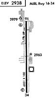
Runways
Runway Summary
| Runways: | 01/19 |
| Longest Runway: | 01/19 is 9300 ft (2835 m) long |
| Runways with an Instrument Approach: | 19 |
SGU Airport Runway Details
| Runway 01/19 | 9300 ft x 150 ft (2835 m x 46 m) | |
| Runway Length Source: | 3RD PARTY SURVEY as of 11/18/2019 | |
| Surface: | Asphalt - Good condition - Saw-cut or plastic grooved | |
| Runway Edge Lights: | High Intensity | |
Runway Weight Bearing Capacity (in thousands of pounds) |
||
| Single Wheel Landing Gear: | 75.0 | |
| Dual Wheel Landing Gear: | 150.0 | |
Runway 01 |
Runway 19 |
|
Elevation: |
2831.7 | 2883.6 |
Latitude: |
37-01-28.6413N | 37-02-53.2798N |
Longitude: |
113-30-59.4836W | 113-30-14.6887W |
|
Runway True Alignment: |
023 | 203 |
ILS Type: |
LDA/DME | |
Glide Path Angle: |
3.0 degrees | 3.1 degrees |
Runway Markings Type: |
Precision Instrument | Precision Instrument |
Runway Markings Condition: |
Good | Good |
Visual Glide Slope Indicators: |
4-Light PAPI On Left Side Of Runway | 4-Light PAPI On Left Side Of Runway |
Approach Light System: |
1,400 Foot Medium Intensity Approach Lighting System With Runway Alignment Indicator Lights | |
REIL: |
Yes | No |
Threshold Crossing Height: |
50 | 55 |
Declared Distances |
||
Take Off Run Avbl. (TORA): |
9300 | 9300 |
Take Off Distance Avbl. (TODA): |
9300 | 9300 |
Actual Stop Dist. Avbl. (ASDA): |
9300 | 9300 |
Landing Dist. Avbl. (LDA): |
9300 | 9300 |
Services
Airframe Repair: |
Major |
Powerplant Repair: |
Major |
Bottled Oxygen: |
High Pressure / Low Pressure |
Bulk Oxygen: |
High Pressure |
Fuel Available: |
100LL, Jet A |
Parking: |
Tiedowns available |
Maps & Diagrams
SGU Sectional
Flight Planning
at skyvector.com
at skyvector.com